Traversing the Clay-Bearing Unit Along the Base of VRR, Site 73-79, sol 2297-2695, 22 Jan 2019-3 Mar 2020 |

  |
Traversing the Clay-Bearing Unit Along the Base of VRR, Site 73-79, sol 2297-2695, 22 Jan 2019-3 Mar 2020 |
 Mar 21 2019, 11:41 PM Mar 21 2019, 11:41 PM
Post
#76
|
|
 Senior Member  Group: Members Posts: 2428 Joined: 30-January 13 From: Penang, Malaysia. Member No.: 6853 |
QUOTE (fredk @ Mar 21 2019, 10:58 PM)  The darker frames' filenames end in "...C00_DXXX", versus "...K00_DXXX" for the rest, so there must be something different about the exposure or stretching on those. Many thanks for the feedback, I'd not spotted the file name changes. Disappointing, was hoping it was a DD 
|
 |
 
|
|
Mar 22 2019, 01:18 AM
Post
#77
|
||
|
Senior Member Group: Members Posts: 2428 Joined: 30-January 13 From: Penang, Malaysia. Member No.: 6853 |
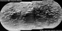
Long distance RMI of an outcrop located North(?) of the rover on sol 2354
|
|
|
|
|
|
|
Mar 22 2019, 02:20 PM
Post
#78
|
||
|
Senior Member Group: Members Posts: 2820 Joined: 22-April 05 From: Ridderkerk, Netherlands Member No.: 353 |
The Navcam L view on Sol 2350.
Jan van Driel
|
|
|
|
|
|
|
Mar 22 2019, 05:34 PM
Post
#79
|
|
|
Senior Member Group: Members Posts: 2511 Joined: 13-September 05 Member No.: 497 |
QUOTE (fredk @ Mar 21 2019, 06:58 AM) The darker frames' filenames end in "...C00_DXXX", versus "...K00_DXXX" for the rest, so there must be something different about the exposure or stretching on those. C means losslessly-compressed 8-bit raster image and K means losslessly-compressed 8-bit raster video, so by itself that doesn't say anything about the exposure (see https://pds-imaging.jpl.nasa.gov/data/msl/M...R_RDR_DPSIS.PDF ) but if you don't have the metadata you have no way to know what the exposure times were. -------------------- Disclaimer: This post is based on public information only. Any opinions are my own.
|
|
|
|
|
Mar 23 2019, 12:54 AM
Post
#80
|
||
|
Member Group: Members Posts: 866 Joined: 15-March 05 From: Santa Cruz, CA Member No.: 196 |
QUOTE (PaulH51 @ Mar 21 2019, 06:18 PM) Long distance RMI of an outcrop located North(?) of the rover on sol 2354 very nice, eons of wind sculpting have given its features a very appealing lens-like texture.
and yep its almost exactly North from here, part of the underexposed outcrop in the upper left of the navcam from sol2352 much better views in the bayered mastcam sol2353 or most recent color mastcam from sol2320 |
|
|
|
|
|
|
Mar 23 2019, 04:19 PM
Post
#81
|
||
|
Senior Member Group: Members Posts: 2820 Joined: 22-April 05 From: Ridderkerk, Netherlands Member No.: 353 |
The Navcam L view on Sol 2354.
Jan van Driel
|
|
|
|
|
|
|
Mar 24 2019, 03:30 PM
Post
#82
|
||
|
Senior Member Group: Members Posts: 2820 Joined: 22-April 05 From: Ridderkerk, Netherlands Member No.: 353 |
Playing with a few images on a Sunday afternoon.
Sol 2353 Mastcam L view. Jan van Driel
|
|
|
|
|
|
|
Mar 25 2019, 07:01 PM
Post
#83
|
||
|
Senior Member Group: Members Posts: 2820 Joined: 22-April 05 From: Ridderkerk, Netherlands Member No.: 353 |
and the complete Mastcam L view on Sol 2353.
Jan van Driel
|
|
|
|
|
|
|
Mar 25 2019, 08:56 PM
Post
#84
|
|
|
Member Group: Members Posts: 866 Joined: 15-March 05 From: Santa Cruz, CA Member No.: 196 |
|
|
|
|
|
Mar 26 2019, 03:12 AM
Post
#85
|
||
|
Senior Member Group: Members Posts: 2428 Joined: 30-January 13 From: Penang, Malaysia. Member No.: 6853 |
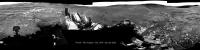
Looks like this is the L-MastCam drive direction section of what will be a wider mosaic from sol 2357 (MS-ICE / slightly darkened)
The mission update talked about speculation that the lone float rock (left of center) could be a meteorite or possibly or a remnant of a higher, eroded unit, but the next drive will take the rover to the subtle ridges (visible just to the left of the float rock) and image the float rock from there as well as the small butte in the middle of this mosaic.
|
|
|
|
|
|
|
Mar 26 2019, 03:47 AM
Post
#86
|
||
|
Senior Member Group: Members Posts: 2428 Joined: 30-January 13 From: Penang, Malaysia. Member No.: 6853 |
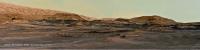
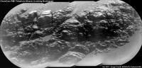
Long distance RMI mosaic of another exposure of the Vera Rubin Ridge, this time looking Northwest of the rover during sol 2357.
I used the 4 enhanced data product frames for this mosaic, a fifth image was not available in that format when I assembled this in MS-ICE, no additional processing except for adding the annotations.
|
|
|
|
|
|
|
Mar 26 2019, 10:06 AM
Post
#87
|
||
|
Senior Member Group: Members Posts: 2428 Joined: 30-January 13 From: Penang, Malaysia. Member No.: 6853 |
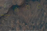
Posted this here to keep the signal to noise ratio down on the map thread. I've annotated my guesstimate of where the rover is after its drive on sol 2357 onto a crop of the JPL location map for sol 2354, but that's not the main reason for this post. For fun I'm looking at potential drill / sample sites in the clay unit...
I've circled three possible sites: A, B and C: My favourite at the moment is A, with C running a close second, C looks to have more potential, but it's a little off the published path.
|
|
|
|
|
|
|
Mar 26 2019, 01:58 PM
Post
#88
|
||
|
Senior Member Group: Members Posts: 2820 Joined: 22-April 05 From: Ridderkerk, Netherlands Member No.: 353 |
The Navcam L view on Sol 2357.
Jan van Driel
|
|
|
|
|
|
|
Mar 26 2019, 06:09 PM
Post
#89
|
||
 Senior Member Group: Members Posts: 4246 Joined: 17-January 05 Member No.: 152 |
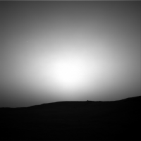
We had a transient darkening of the sky just after sunset on 2358. All I can think of is a Phobos transit, with centreline just to our north. Very cool. Here's an animation:
|
|
|
|
|
|
|
Mar 26 2019, 06:15 PM
Post
#90
|
|
|
Founder Group: Chairman Posts: 14432 Joined: 8-February 04 Member No.: 1 |
QUOTE (fredk @ Mar 26 2019, 10:09 AM) All I can think of is a Phobos transit Well spotted 
|
|
|
|
|

|
Lo-Fi Version | Time is now: 26th April 2024 - 08:17 AM |
|
RULES AND GUIDELINES Please read the Forum Rules and Guidelines before posting. IMAGE COPYRIGHT |
OPINIONS AND MODERATION Opinions expressed on UnmannedSpaceflight.com are those of the individual posters and do not necessarily reflect the opinions of UnmannedSpaceflight.com or The Planetary Society. The all-volunteer UnmannedSpaceflight.com moderation team is wholly independent of The Planetary Society. The Planetary Society has no influence over decisions made by the UnmannedSpaceflight.com moderators. |
SUPPORT THE FORUM Unmannedspaceflight.com is funded by the Planetary Society. Please consider supporting our work and many other projects by donating to the Society or becoming a member. |
|