Crossing the Dunes at Murray Buttes, Sites 54-62, Sols 1353-1659, May 28 2016-Apr 6 2017 |

Crossing the Dunes at Murray Buttes, Sites 54-62, Sols 1353-1659, May 28 2016-Apr 6 2017 |
 May 27 2016, 11:01 AM May 27 2016, 11:01 AM
Post
#1
|
||
 Senior Member  Group: Members Posts: 2429 Joined: 30-January 13 From: Penang, Malaysia. Member No.: 6853 |
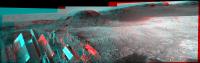
Midnight Planets has reported Curiosity's movement of ~46.3m WSW (-116º) on Sol 1353.
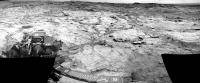
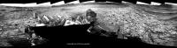
Only 7 L-NavCams were available for this rough & ready stitch in MS ICE, the raws are a little overexposed, but they may assist in pinpointing the location. I cropped the stitch a little to get it under the upload limit. I'll post the full resolution 360 on an image host as the images become available, unless someone beats me to it 
|
|
 |
 
|
|
 |
|
May 28 2016, 03:49 AM
Post
#2
|
||
|
Senior Member Group: Members Posts: 2429 Joined: 30-January 13 From: Penang, Malaysia. Member No.: 6853 |
Curiosity Mission Update by Ryan Anderson, dated 27 May 2016 - Sol 1355-1357: Coordinating with MRO
QUOTE Our drive went well and Curiosity is now sitting on a nice patch of the Murray formation, putting us in a good position for a very busy holiday weekend! On Sol 1355, ChemCam has observations of the targets Auchas, Kaisosi, Inamagando, and Horingbaai. Mastcam will document those targets and then do some multispectral observations of the targets Kunjas and Navachab, plus a mosaic of the contact between the Murray and Stimson units. Navcam will round out the science block with some atmospheric observations. Sol 1356 was an unusual one, with a bunch of small science blocks spread throughout the day. These were to enable a series of measurements leading up to a coordinated set of observations in the afternoon between the instruments on the rover on the Mars Reconnaissance Orbiter. (Yes, this means a new HiRISE image of Curiosity is coming soon!) First thing in the morning on Sol 1356, Mastcam and Navcam have a photometry observation. This is repeated a few hours later along with a multispectral Mastcam observation of the target Inamagando. A few hours later, the photometry observation is repeated again (the idea is to see how the brightness changes as the sun angle changes) and ChemCam has a passive sky observation. Finally, there is another photometry observation, a Mastcam sky survey observation, and Mastcam sky flats. These are followed by a long-distance ChemCam RMI image that I managed to squeeze into the plan. I am hoping that the similar time of day (and therefore similar lighting) will make it easier to compare the HiRISE and RMI images. After the RMI, Sol 1356 will wrap up with one final photometry observation. On Sol 1357 we will drive again, followed by standard post-drive imaging. This plan will take us through the long weekend, so our next planning day will be on Tuesday.
|
|
|
|
|
|
|
May 29 2016, 03:38 AM
Post
#3
|
|
|
Senior Member Group: Members Posts: 2429 Joined: 30-January 13 From: Penang, Malaysia. Member No.: 6853 |
|
|
|
|
|
May 29 2016, 04:07 AM
Post
#4
|
||
|
Senior Member Group: Members Posts: 2429 Joined: 30-January 13 From: Penang, Malaysia. Member No.: 6853 |
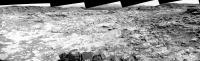
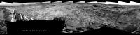
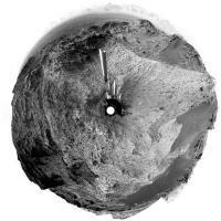
R-NavCam Sol 1353 Pano, complete with some data-drop-out and stitching errors, but may help users to understand the terrain until a better version comes along.
Preview (500 pxl)
Imgur 8192x1854 pixels. |
|
|
|
|
|
|
May 30 2016, 05:53 AM
Post
#5
|
||
|
Solar System Cartographer Group: Members Posts: 10164 Joined: 5-April 05 From: Canada Member No.: 227 |
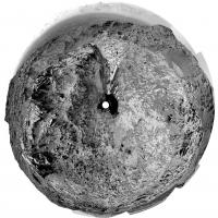
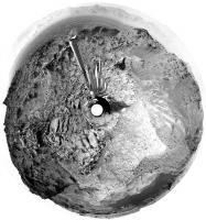
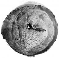
Here is Paul's full panorama from sol 1353 in circular form. It shows the tracks did follow the rock outcrops as I guessed in my map. Looks like we have a good run to the south now.
Phil
-------------------- ... because the Solar System ain't gonna map itself.
Also to be found posting similar content on https://mastodon.social/@PhilStooke Maps for download (free PD: https://upload.wikimedia.org/wikipedia/comm...Cartography.pdf NOTE: everything created by me which I post on UMSF is considered to be in the public domain (NOT CC, public domain) |
|
|
|
|
|
|
May 31 2016, 01:04 AM
Post
#6
|
||
|
Senior Member Group: Members Posts: 2429 Joined: 30-January 13 From: Penang, Malaysia. Member No.: 6853 |
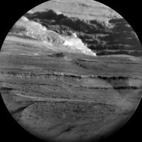
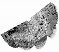
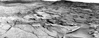
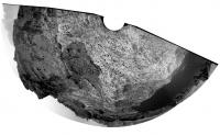
Sol 1356: Long-Distance ChemCam-RMI mosaic, centered on SSE - Mt Sharp. Quickly assembled in MS ICE using the 9 available Enhanced Data Product frames. Shows more of the detail of the extensive layering in the lower reaches of the mountain.
Width reduced to 2500 pxls
|
|
|
|
|
|
|
May 31 2016, 02:20 AM
Post
#7
|
||
 Member Group: Members Posts: 684 Joined: 24-July 15 Member No.: 7619 |
QUOTE (PaulH51 @ May 31 2016, 02:04 AM)  Sol 1356: Long-Distance ChemCam-RMI mosaic, centered on SSE - Mt Sharp. Quickly assembled in MS ICE using the 9 available Enhanced Data Product frames. Shows more of the detail of the extensive layering in the lower reaches of the mountain. Width reduced to 2500 pxls
Wow, just wow. Literally a picture worth a thousand words. |
|
|
|
|
|
|
May 31 2016, 03:24 PM
Post
#8
|
|
 Administrator Group: Admin Posts: 5172 Joined: 4-August 05 From: Pasadena, CA, USA, Earth Member No.: 454 |
New thread time! Now that Curiosity's wheels are back on Murray, we'll stick with this thread for a while. Here's a 3D route map giving some context for where we need to go next. It'll be roughly 2 km of driving with sand dunes on our left and the Murray Buttes on our right. I'm not sure if there are plans to do much in the way of science stops along that traverse; I guess it depends on how different the Murray is here compared to its appearance at Pahrump hills.
-------------------- My website - My Patreon - @elakdawalla on Twitter - Please support unmannedspaceflight.com by donating here.
|
|
|
|
|
May 31 2016, 11:16 PM
Post
#9
|
|
|
Senior Member Group: Members Posts: 2429 Joined: 30-January 13 From: Penang, Malaysia. Member No.: 6853 |
Another drive on sol 1357: ~7 meters West followed by a short bump to the North, see Midnight Planets
Hopefully we'll get enough of the end-of-drive NavCams to assemble the pano soon. |
|
|
|
|
Jun 1 2016, 11:04 PM
Post
#10
|
||
|
Senior Member Group: Members Posts: 2429 Joined: 30-January 13 From: Penang, Malaysia. Member No.: 6853 |
Curiosity Mission Update by Ryan anderson, dated 31 May 2016 - Sol 1358: A Simple Plan
QUOTE Our activities over the weekend went well, and after a couple of complicated multi-sol plans we get to do a nice simple one-sol plan today! The Sol 1358 plan starts with ChemCam observations of the targets Otiiha, Otjihase, Otjikoto, and Otjimbingwe to assess variations in the bedrock chemistry. Mastcam will document those targets, and then we will dump out our remaining Okoruso sample. APXS then has an overnight observation of the target Oudam. I was on downlink for ChemCam today, so while everyone was putting together the plan for today, I was busy analyzing the tons of great data that we got down over the long weekend!
|
|
|
|
|
|
|
Jun 2 2016, 01:25 AM
Post
#11
|
||
|
Senior Member Group: Members Posts: 2429 Joined: 30-January 13 From: Penang, Malaysia. Member No.: 6853 |
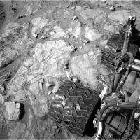
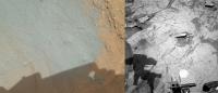
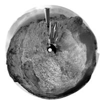
Sol 1358: The Okoruso drill sample dumped from CHIMRA (MAHLI & NavCam for context)
|
|
|
|
|
|
|
Jun 2 2016, 02:18 PM
Post
#12
|
|
|
Administrator Group: Admin Posts: 5172 Joined: 4-August 05 From: Pasadena, CA, USA, Earth Member No.: 454 |
It's fascinating how dark the dump pile looks in Navcam. Navcams have red/IR filters on them (600-800nm), so the (relatively) blue tailings pile looks a lot darker to Navcam than it does to Mastcam/MAHLI.
-------------------- My website - My Patreon - @elakdawalla on Twitter - Please support unmannedspaceflight.com by donating here.
|
|
|
|
|
Jun 2 2016, 11:01 PM
Post
#13
|
|
|
Senior Member Group: Members Posts: 2429 Joined: 30-January 13 From: Penang, Malaysia. Member No.: 6853 |
QUOTE (elakdawalla @ Jun 2 2016, 10:18 PM) It's fascinating how dark the dump pile looks in Navcam. When I shared that image elsewhere I had to add an arrow to point out the dump pile on the NavCam context image due to apparent colour differences And the latest from USGS:- Curiosity Mission Update by Ken Herkenhoff, dated 02 Jun 2016 - Sol 1360: Preparing to drill QUOTE Arm work continues to go well, so preparation for drilling and sample analysis is the focus of the Sol 1360 plan. First, CheMin will dump the Lubango and Okoruso drill samples out of their cells. Then ChemCam and Mastcam will observe a bright vein named "Charlottenfelder" and a bedrock target called "Chameis Bay" before arm activities resume. MAHLI will take close-up images of the Oudam drill target and a single image of the "footprint" that APXS likely made on the Okoruso dump pile yesterday. Overnight, CheMin will analyze an empty cell to provide a baseline measurement before receiving the new drill sample. Early the next morning, before handover to the next plan, observations of the Sun and sky will measure dust in the atmosphere over the rover and search for clouds and dust devils. The Right Mastcam will take a 10-image mosaic of the "Otjizonjati" outcrop northwest of the rover when it is well-illuminated by the morning sun. Finally, the RMI will acquire a 5-image mosaic of part of Aeolis Mons (Mount Sharp) toward the south. |
|
|
|
|
Jun 2 2016, 11:04 PM
Post
#14
|
|
|
Administrator Group: Admin Posts: 5172 Joined: 4-August 05 From: Pasadena, CA, USA, Earth Member No.: 454 |
I didn't expect them to drill again so soon. In hindsight, it makes sense; I guess they want to see if the Murray here is any different than it was on the other side of the plateau.
Also, I didn't know they could keep two different samples in CheMin at the same time! -------------------- My website - My Patreon - @elakdawalla on Twitter - Please support unmannedspaceflight.com by donating here.
|
|
|
|
|
Jun 3 2016, 01:04 AM
Post
#15
|
|
|
Senior Member Group: Members Posts: 2429 Joined: 30-January 13 From: Penang, Malaysia. Member No.: 6853 |
QUOTE (elakdawalla @ Jun 3 2016, 07:04 AM) I didn't expect them to drill again so soon. They have already completed the load tests and the overnight APXS, I guess we will know soon if they were acceptable. R-MastCam Mosaic featuring the drill target (center of the mosaic) assembled in MS ICE 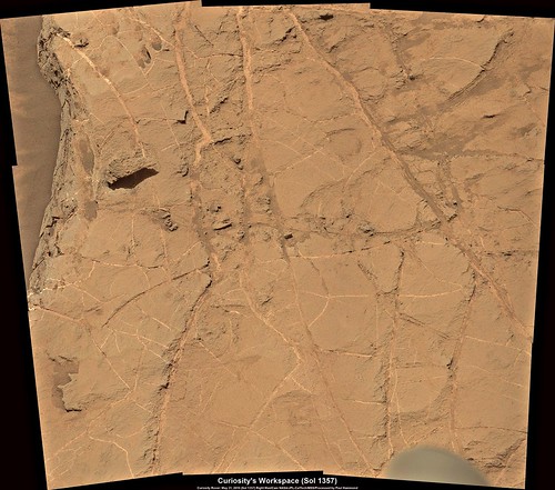 Flickr 1024x904 Flickr 3772x3330 |
|
|
|
|
Jun 3 2016, 07:29 PM
Post
#16
|
||
|
Senior Member Group: Members Posts: 2831 Joined: 22-April 05 From: Ridderkerk, Netherlands Member No.: 353 |
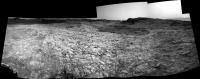
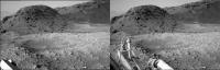
The Navcam L view on Sol 1357.
Jan van Driel
|
|
|
|
|
|
|
Jun 4 2016, 03:03 AM
Post
#17
|
|
|
Senior Member Group: Members Posts: 2429 Joined: 30-January 13 From: Penang, Malaysia. Member No.: 6853 |
Curiosity Mission Update by Ken Herkenhoff, dated 03 Jun 2016. Sols 1361-1363: Drilling Oudam:
QUOTE The MSL Rover Planners have all the data they need to drill (no "mini-drill" required), so the plan for this weekend focuses on drilling into the Oudam bedrock target. The full drill is scheduled for Sol 1361, followed by MAHLI and Mastcam images of the new hole. The rover will then rest until Sol 1362, when the drill sample will be transferred to the scoop for Mastcam imaging and sieved. A fine-grained (<0.15 mm) portion of the sample then will be dropped into CheMin for an overnight mineralogical analysis. After the CheMin data are read out of the instrument on Sol 1363, Mastcam will take a multispectral set of images of the drill tailings and a Right Mastcam mosaic of an outcrop southeast of the rover. In addition, ChemCam and Mastcam will observe a vein target named "Onganja" and a bedrock target dubbed "Ongeama," and Navcam will search for dust devils. Another busy weekend for MSL! |
|
|
|
|
Jun 4 2016, 09:57 PM
Post
#18
|
||
|
Senior Member Group: Members Posts: 2429 Joined: 30-January 13 From: Penang, Malaysia. Member No.: 6853 |
Sol 1361 MAHLI, our latest sample hole at Oudam
|
|
|
|
|
|
|
Jun 4 2016, 10:18 PM
Post
#19
|
||
|
Administrator Group: Admin Posts: 5172 Joined: 4-August 05 From: Pasadena, CA, USA, Earth Member No.: 454 |
 Also:
-------------------- My website - My Patreon - @elakdawalla on Twitter - Please support unmannedspaceflight.com by donating here.
|
|
|
|
|
|
|
Jun 5 2016, 02:03 AM
Post
#20
|
|
|
Senior Member Group: Members Posts: 2429 Joined: 30-January 13 From: Penang, Malaysia. Member No.: 6853 |
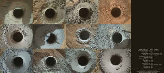
Always enjoy Emily's montage's of MSL's drill sites, Each time it is published I wonder how large that montage will be when the mission is complete
Here is a rough animation. No movement of the bedrock this time  Link to full size LINK |
|
|
|
|
Jun 6 2016, 02:01 AM
Post
#21
|
|
 Member Group: Members Posts: 691 Joined: 21-December 07 From: Clatskanie, Oregon Member No.: 3988 |
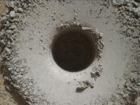
Here is my version of the drill hole gif. I haven't seen this done before, but I thought it would be interesting to see the hole without the drill tailings like it was brushed or blown away by the wind as well as what the hole may look like many years down the road after long term dust settling again.
Edit: For those that didn't know, Curiosity carries a 1909 VDB lincoln wheat penny on MAHLI's calibration target for inserting into images like this for scale. 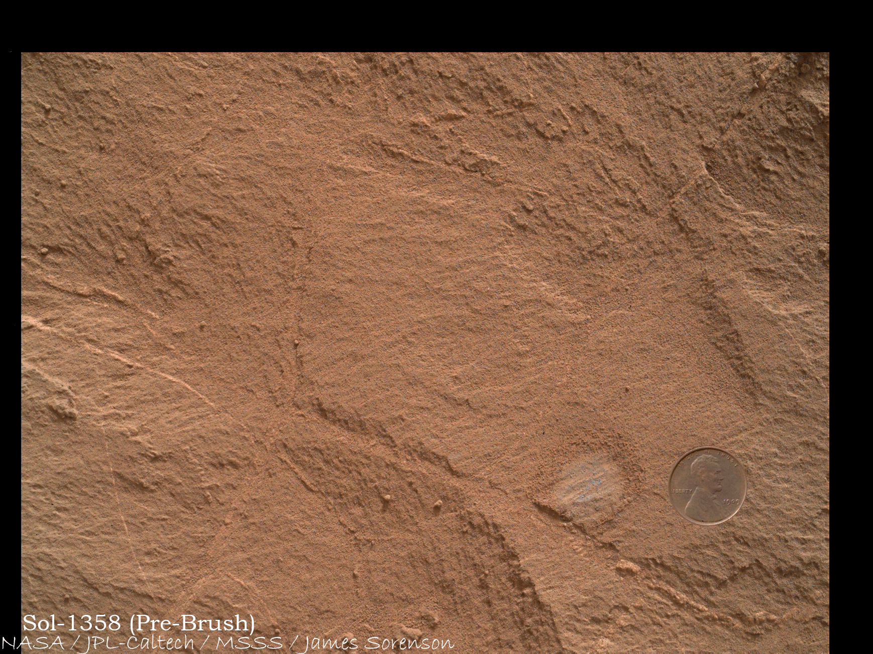
|
|
|
|
|
Jun 6 2016, 03:11 AM
Post
#22
|
|
|
Member Group: Members Posts: 691 Joined: 21-December 07 From: Clatskanie, Oregon Member No.: 3988 |
Oh and that penny in the future image of the hole must have some magical dust repelling properties

|
|
|
|
|
Jun 7 2016, 03:58 AM
Post
#23
|
|||
|
Senior Member Group: Members Posts: 2429 Joined: 30-January 13 From: Penang, Malaysia. Member No.: 6853 |
Sol 1363 L-MastCam Rover Deck / CHEMIN Inlet Port Cover.
An interesting pattern of the surface dust has developed on the outside of the cover. I looked back at the early images of the deck instruments acquired on sol 36, these show the port covers from SAM in the open / closed positions and were featured by JPL in a rather nice animation at the time. However in a short search I did not find an image of the open CHEMIN port cover, as I suspect the pattern may match strengthening ribs on the underside of the cover. Has anyone seen any manufacturing / assemble stage images of this cover? Note: The pattern is visible in both the 'before and after' images related to inserting a sample. I can't recall observing this on earlier images. My question is... How did the pattern form? Thinking out loud, we could have had some frost or differential condensation on the cover followed by a dusting event that resulted in the pattern we see today. Any other ideas welcome I'm also wondering if we will be able to observe the formation of patterns on SAM's covers, after placing the Oudam sample inside in the coming days.
|
||
|
|
|
||
|
Jun 7 2016, 05:58 AM
Post
#24
|
||
|
Senior Member Group: Members Posts: 2429 Joined: 30-January 13 From: Penang, Malaysia. Member No.: 6853 |
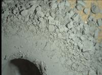
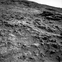
More mud cracks? (raw Sol 1352 R-MastCam)
Edit... There are a lot more examples, full mosaic to follow once I have all the images
|
|
|
|
|
|
|
Jun 7 2016, 07:43 AM
Post
#25
|
|
|
Member Group: Members Posts: 691 Joined: 21-December 07 From: Clatskanie, Oregon Member No.: 3988 |
QUOTE (PaulH51 @ Jun 6 2016, 08:58 PM) Note: The pattern is visible in both the 'before and after' images related to inserting a sample. I can't recall observing this on earlier images. My question is... How did the pattern form? It is clearly an exact imprint of the fidicual target that is seen here in the pre launch mastcam selfie in the thermal vac chamber. Now the question is why is this still visible if it was removed before launch? Perhaps left over adhesive and dust or frost is clinging to it now making it more visible? Hmmm.... http://marsmobile.jpl.nasa.gov/msl/news/wh...amp;NewsID=1130 |
|
|
|
|
Jun 7 2016, 08:09 AM
Post
#26
|
|
|
Senior Member Group: Members Posts: 2429 Joined: 30-January 13 From: Penang, Malaysia. Member No.: 6853 |
QUOTE (James Sorenson @ Jun 7 2016, 03:43 PM) It is clearly an exact imprint of the fidicual target that is seen here in the pre launch mastcam selfie in the thermal vac chamber. Now the question is why is this still visible if it was removed before launch? Perhaps left over adhesive and dust or frost is clinging to it now making it more visible? Hmmm.... Great call on the fiducial targets James... I usually look at these before & after images of the port covers looking for dust trails, hoping to make an animation, but the wind shields have usually done a good job of keeping the covers fairly clear. As you say adhesive residues sounds plausible, but why have we had to wait nearly 4 years to see the effect... It does not seem likely that they would have been painted over before launch, I saw the red organic sample boxes and thought maybe some painting followed the test, but I figure that those are not the flight canisters? Edit: typo corrected 'fiducial' |
|
|
|
|
Jun 7 2016, 11:36 AM
Post
#27
|
|
|
Member Group: Members Posts: 684 Joined: 24-July 15 Member No.: 7619 |
QUOTE (PaulH51 @ Jun 7 2016, 09:09 AM) As you say adhesive residues sounds plausible, but why have we had to wait nearly 4 years to see the effect... Hmm, very interesting point. Most commercial adhesives are water sensitive acrylics, What is the recent history of humidity around the rover? Seems like you've stumbled across a simple and direct way to measure martian humidity.... |
|
|
|
|
Jun 7 2016, 11:53 AM
Post
#28
|
|
|
Senior Member Group: Members Posts: 2429 Joined: 30-January 13 From: Penang, Malaysia. Member No.: 6853 |
QUOTE (HSchirmer @ Jun 7 2016, 07:36 PM) What is the recent history of humidity around the rover? The Spanish REMS web page is not currently reporting humidity, only daily min/max air and ground temperatures and pressure, and those don't appear to be out of the ordinary for the rover. Yes, should apply patches of that adhesive to sections of the 2020 deck, maybe get some interesting and cheap returns 
|
|
|
|
|
Jun 7 2016, 03:14 PM
Post
#29
|
|
 Senior Member Group: Members Posts: 4247 Joined: 17-January 05 Member No.: 152 |
The pattern was visible on sol 36 - look along the thin bright stripe on the cover in this image:
http://mars.jpl.nasa.gov/msl-raw-images/ms...0000E1_DXXX.jpg Is humidity necessary for this? We know it's very dry here. Why not simply dust accumulating slowly onto glue residue? Another factor may be the direction of solar illumination - the new 1362 image has a fairly high phase angle. |
|
|
|
|
Jun 7 2016, 05:59 PM
Post
#30
|
|
|
Member Group: Members Posts: 684 Joined: 24-July 15 Member No.: 7619 |
QUOTE (fredk @ Jun 7 2016, 03:14 PM) Is humidity necessary for this? We know it's very dry here. Why not simply dust accumulating slowly onto glue residue? Another factor may be the direction of solar illumination - the new 1362 image has a fairly high phase angle. Hey, not necessarily, a glue is basically a formulation of very slow-drying paint, the effect looked like it was due to something "sticky" but it could be texture or actual darkening. The difference in appearance could be a result of adhesive residue causing a rougher surface, but could also be glue residue itself darkening, acrylic does react to UV exposure. |
|
|
|
|
Jun 7 2016, 06:28 PM
Post
#31
|
|
|
Member Group: Members Posts: 122 Joined: 19-June 07 Member No.: 2455 |
Could it simply be that the material used for the ribbing is naturally magnetic?
|
|
|
|
|
Jun 8 2016, 01:22 AM
Post
#32
|
|
|
Senior Member Group: Members Posts: 2429 Joined: 30-January 13 From: Penang, Malaysia. Member No.: 6853 |
Curiosity Mission Update by Ken Herkenhoff, dated 06 Jun 2016. Sols 1364-1365: Analyzing drill sample:
QUOTE The Oudam drill campaign continues to go well, with sample acquired and ready for analysis. Planning is now restricted, so we are planning 2 sols today. On Sol 1364, ChemCam will acquire passive spectra of the drill tailings and a LIBS raster of the wall of the drill hole. Later that afternoon, the unsieved portion of the drill sample will be dumped on the ground and imaged by MAHLI from 25 cm to support future planning. After dark, MAHLI will take pictures of the inside of the drill hole, the tailings, and the CheMin inlet using its LEDs for illumination. The APXS will then be placed on the drill tailings for an overnight integration. Early on Sol 1365, the Right Mastcam will extend the mosaic of Hartmann's Valley, adding 22 images. That afternoon, the APXS will be retracted and vibrated to clean it, then the arm will be moved out of the way for ChemCam and Mastcam observations of the drill tailings. Navcam will search for clouds both near the horizon and at zenith. Finally, CheMin will analyze the drill sample overnight. |
|
|
|
|
Jun 8 2016, 05:31 AM
Post
#33
|
|
|
Member Group: Members Posts: 691 Joined: 21-December 07 From: Clatskanie, Oregon Member No.: 3988 |
I like the "UV darkening of the adhesive" theory. The trouble that I'm having though with it possibly being adhesive is it appears to take an exact imprint of the pattern like the pattern was intricately cutout then bonded which would support what we are seeing but that seems a little unlikely. I would have thought the pattern would be printed on some sort of backing surface with then a uniform adhesive on the back, which is not what we are seeing if that was the case. Need more information on these particular fidicual targets, how they were made and applied, and why they were removed. Though the latter isn't as important to know.
|
|
|
|
|
Jun 8 2016, 11:31 AM
Post
#34
|
|
|
Senior Member Group: Members Posts: 2429 Joined: 30-January 13 From: Penang, Malaysia. Member No.: 6853 |
QUOTE (James Sorenson @ Jun 8 2016, 01:31 PM) I would have thought the pattern would be printed on some sort of backing surface with then a uniform adhesive on the back, which is not what we are seeing if that was the case. I really enjoy a good detective story So I throw a possible clue onto the table (just for fun)...I looked at the Photo-Journal page for PIA14131 which make reference to a 'space simulation chamber at JPL' Google pointed me to the actual chamber used LINK which even has a photo of Curi in the chamber before the doors were closed. The chamber contains a large 'collimating mirror' on the seiling that collects light from 37 xenon arc lamps installed in a 'solar basement,' and focuses the light onto a test subject. Each of the lamps are 20 to 25-kilowatts depending on which reference I found... the other link to the test chamber (Chamber 25 Space Simulator, Building 150) LINK So, returning to Jame's comment about one piece labels with a uniform adhesive / UV darkening etc. Xenon arc lamps produce a lot of light and a lot of UV, maybe enough to alter the backing adhesive of the temporary fiducial targets on the port covers. But why the different effects leaving our matching pattern behind? Possibly the intense UV from the xenon lamps passed through the black and white fiducial marks differently, one section being masked? Maybe this resulted in some change in sections of the uniform adhesive where some was altered or baked onto the surface? Just another 2 cents towards this discussion
|
|
|
|
|
Jun 8 2016, 03:54 PM
Post
#35
|
|
|
Senior Member Group: Members Posts: 2517 Joined: 13-September 05 Member No.: 497 |
QUOTE (James Sorenson @ Jun 7 2016, 09:31 PM) I would have thought the pattern would be printed on some sort of backing surface with then a uniform adhesive on the back... If you look at the original M34 raw images taken in the system thermal test (sorry, can't share), you can see that the background color is identical to the cover's, so there is no backing surface as far as I can tell at the resolution of the image. It looks like a cut decal, very conformal to the cover. I don't know more about the story of this target, but I have some inquiries in. [EDIT] Ah, the full story. The covers were originally black-anodized but were found to be flaking ( http://llis.nasa.gov/lesson/8403 .) Seems like the original white target got stripped off when the covers were reanodized but there was some residual etching and that's what you're seeing. -------------------- Disclaimer: This post is based on public information only. Any opinions are my own.
|
|
|
|
|
Jun 8 2016, 04:52 PM
Post
#36
|
|
|
Member Group: Members Posts: 684 Joined: 24-July 15 Member No.: 7619 |
QUOTE (mcaplinger @ Jun 8 2016, 03:54 PM) If you look at the original M34 raw images taken in the system thermal test (sorry, can't share), you can see that the background color is identical to the cover's, so there is no backing surface as far as I can tell at the resolution of the image. It looks like a cut decal, very conformal to the cover. I don't know more about the story of this target, but I have some inquiries in. [EDIT] Ah, the full story. The covers were originally black-anodized but were found to be flaking ( http://llis.nasa.gov/lesson/8403 .) Hey, two birds with one stone- the crosshair pattern and mudcrack flaking. Seems the rover's aluminum was developing a mini-mudcrack pattern as the anodized layer flaked off... 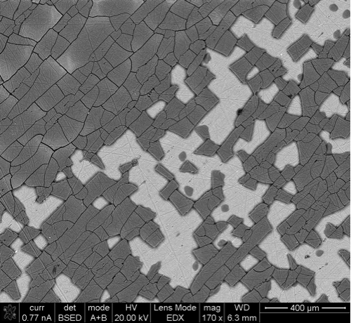 SEM images of the flaking surface showed a micro-cracking or crazing of the surface with much of the anodize removed. |
|
|
|
| Guest_Steve5304_* |
Jun 8 2016, 07:02 PM
Post
#37
|
|
Guests |
So this pretty much tells us mars atmosphere eats and corrodes stuff over a period of time. Much more than earth... That explains the wasteland of hollow rocks.
|
|
|
|
|
Jun 8 2016, 07:07 PM
Post
#38
|
|
|
Senior Member Group: Members Posts: 4247 Joined: 17-January 05 Member No.: 152 |
How does it tell us that? The anodized coating flaking was during testing on earth, if that's what you meant.
The pattern visible in mastcam now is due to residual etching according to mcaplinger. Perhaps it was especially noticable due to the large phase angle. |
|
|
|
|
Jun 8 2016, 07:28 PM
Post
#39
|
|
|
Member Group: Members Posts: 684 Joined: 24-July 15 Member No.: 7619 |
QUOTE (Steve5304 @ Jun 8 2016, 07:02 PM) So this pretty much tells us mars atmosphere eats and corrodes stuff over a period of time. Much more than earth... That explains the wasteland of hollow rocks. Sorry, I should have been clearer - Curiosity has tan lines. Instead of spring breakers writing-on-somebody-with-sun-tan-lotion, it's engineers, sticker residue and aluminum that was re-anodized on earth. Same end result, you can see the pattern where something protected the surface. The part that seems poetic is that the covers had to be re-anodized because the anodizing flaked off, creating a mud crack pattern, likely due to temperature variation. That same temperature crack pattern seems to appear on the exposed rocks around curiosity. |
|
|
|
|
Jun 8 2016, 08:32 PM
Post
#40
|
|
|
Senior Member Group: Members Posts: 2517 Joined: 13-September 05 Member No.: 497 |
QUOTE (HSchirmer @ Jun 8 2016, 11:28 AM) ...sticker residue and aluminum that was re-anodized on earth. Same end result, you can see the pattern where something protected the surface. To be clear, I don't think there was ever adhesive of any kind. I think the original white pattern was some kind of paint/marking ink (probably epoxy-based, that's what we use for labeling) that was stripped off when the cover was re-anodized. -------------------- Disclaimer: This post is based on public information only. Any opinions are my own.
|
|
|
|
|
Jun 8 2016, 08:49 PM
Post
#41
|
|
|
Senior Member Group: Members Posts: 2429 Joined: 30-January 13 From: Penang, Malaysia. Member No.: 6853 |
QUOTE (mcaplinger @ Jun 9 2016, 04:32 AM) ... I think the original white pattern was some kind of paint/marking ink (probably epoxy-based, that's what we use for labeling) that was stripped off when the cover was re-anodized. Thanks for solving this puzzle I have one remaining question. The reworked cover contains a single white line in place of the fiducial marker on the anodised cover, does that line perform a similar role to the earlier markers? Or does it have a different role? |
|
|
|
|
Jun 8 2016, 09:24 PM
Post
#42
|
|
|
Senior Member Group: Members Posts: 2517 Joined: 13-September 05 Member No.: 497 |
QUOTE (PaulH51 @ Jun 8 2016, 12:49 PM) The reworked cover contains a single white line in place of the fiducial marker on the anodised cover, does that line perform a similar role to the earlier markers? I don't see what you're talking about. As far as I know all of these targets were used for arm checkout and don't have any ongoing operational role, but I could be mistaken. -------------------- Disclaimer: This post is based on public information only. Any opinions are my own.
|
|
|
|
|
Jun 8 2016, 09:31 PM
Post
#43
|
|
|
Member Group: Members Posts: 684 Joined: 24-July 15 Member No.: 7619 |
QUOTE (mcaplinger @ Jun 8 2016, 09:24 PM) I don't see what you're talking about. As far as I know all of these targets were used for arm checkout and don't have any ongoing operational role, but I could be mistaken.  Eh, pretty sure it is the a white line across the lower portion of the "ping-pong-paddle". Hmm, seems like the "handle" is a bit darker than the "face" |
|
|
|
|
Jun 8 2016, 10:35 PM
Post
#44
|
|
|
Senior Member Group: Members Posts: 2517 Joined: 13-September 05 Member No.: 497 |
QUOTE (HSchirmer @ Jun 8 2016, 01:31 PM) Eh, pretty sure it is the a white line across the lower portion of the "ping-pong-paddle". I think that's a step in the face of the cover, not a color difference, but I could be wrong. -------------------- Disclaimer: This post is based on public information only. Any opinions are my own.
|
|
|
|
|
Jun 8 2016, 11:10 PM
Post
#45
|
|
|
Senior Member Group: Members Posts: 1044 Joined: 17-February 09 Member No.: 4605 |
Kudos to fredk for the insight on phase angle which explained why I couldn't find the artefact on earlier deck images taken on Mars and thanks to mcaplinger for taking the time and effort to research the events that caused the anomaly.
|
|
|
|
|
Jun 9 2016, 03:10 AM
Post
#46
|
||
|
Senior Member Group: Members Posts: 2429 Joined: 30-January 13 From: Penang, Malaysia. Member No.: 6853 |
QUOTE (serpens @ Jun 9 2016, 07:10 AM) Kudos to fredk for the insight on phase angle... and thanks to mcaplinger for taking the time and effort to research the events that caused the anomaly. Seconded... Very grateful for everyone's time and knowledge (as always) Curiosity Mission Update by Lauren Edgar, dated 08 Jun 2016 - Sols 1366-1367: Opportunistic contact science QUOTE The day started off with some changes to the sol path due to some holes in the downlink. Unfortunately some engineering camera and MAHLI images from Sol 1364 were not fully transmitted, so the team worked quickly to rearrange the intended activities this week. Fortunately that also meant that we could add in some opportunistic DRT, MAHLI and APXS activities on Sol 1366. The two-sol plan starts off with ChemCam and Mastcam observations of the Oudam drill hole and tailings, and the nearby target Omulonga. Well also acquire some Mastcam and Navcam observations to monitor the atmosphere. In the afternoon of the first sol, well use the DRT, MALHI and APXS to characterize the bedrock target Aubures to look for variations in texture and chemistry within the Murray formation. On the second sol well acquire a 360 degree Mastcam mosaic for geologic context, and a routine SAM electrical baseline test to monitor instrument health. Hopefully the Navcam images will be retransmitted so we can continue with our drill site characterization activities later this week!
|
|
|
|
|
|
|
Jun 9 2016, 10:28 AM
Post
#47
|
|
|
Senior Member Group: Members Posts: 2429 Joined: 30-January 13 From: Penang, Malaysia. Member No.: 6853 |
|
|
|
|
|
Jun 9 2016, 10:37 AM
Post
#48
|
|
|
Member Group: Members Posts: 293 Joined: 22-September 08 From: Spain Member No.: 4350 |
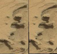
If you look at the shadows, that elongated feature in the lower left is held in the air just by the tip.
|
|
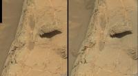
|
|
|
Jun 9 2016, 01:41 PM
Post
#49
|
|
|
Senior Member Group: Members Posts: 2429 Joined: 30-January 13 From: Penang, Malaysia. Member No.: 6853 |
QUOTE (Fran Ontanaya @ Jun 9 2016, 06:37 PM) If you look at the shadows, that elongated feature in the lower left is held in the air just by the tip. We have seen several similar 'near floating' aeolian features. The reduced gravity on Mars will help, as will the lack of rain, but I guess that differential levels of cementation probably played a big role as well as the direction of the prevailing wind.
|
|
|
|
|
Jun 9 2016, 09:34 PM
Post
#50
|
|||||
|
Member Group: Members Posts: 866 Joined: 15-March 05 From: Santa Cruz, CA Member No.: 196 |
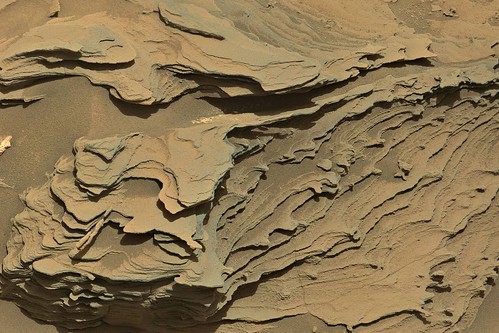
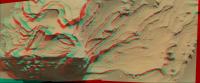
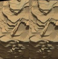
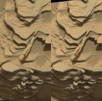
Mars never ceases to amaze! here are stereos (anaglyph/crosseye/parellel) of sol1352 suspended pipe and a stone with piggyback nodule either sitting atop or part of a ledge protuberance..
|
||||
|
|
|
||||
|
Jun 9 2016, 10:58 PM
Post
#51
|
|
|
Senior Member Group: Members Posts: 1044 Joined: 17-February 09 Member No.: 4605 |
Almost nearly but not quite as impressive as Opportunity's berries on stalks.
|
|
|
|
|
Jun 10 2016, 01:06 AM
Post
#52
|
|
|
Member Group: Members Posts: 866 Joined: 15-March 05 From: Santa Cruz, CA Member No.: 196 |
those Oppy berries on stalks were impressive, and i had thought they were comparatively tiny, but turns out i am continually surprised yet again how mastcam inflates everything it images.. so this little schtick that seemed like part of a lost pencil now looks to be but a bit of dried spaghetti, given the proximity to the wheel as imaged by navcam on sol1352 though its too small to determine the jointing to the base rock out in that lo-res shot, so its much lighter than at least i had suspected, not much tensile strength needed at all to preserve such whimsical artifacts being so small.. turns out i had posted a stitch of it unawares back in the previous thread ....yes i guess this post is drifting a little off-thread now based on the sol cutoff for 'crossing the dunes...'
|
|
|
|
|
Jun 10 2016, 05:23 AM
Post
#53
|
|
|
Senior Member Group: Members Posts: 2429 Joined: 30-January 13 From: Penang, Malaysia. Member No.: 6853 |
QUOTE (atomoid @ Jun 10 2016, 09:06 AM) those Oppy berries on stalks were impressive, and i had thought they were comparatively tiny, but turns out i am continually surprised yet again how mastcam inflates everything it images....yes i guess this post is drifting a little off-thread now based on the sol cutoff for 'crossing the dunes...' Ooops, missed the cut off day for the thread... Hopefully the mods can sort this out... I was curious as to the actual size of the feature So.... Using the AlgorimancerPG Photogrammetry and RangeFinder Utility by Clark Andersen, I measured the length of the pencil like structure using the L&R NavCam images from sol 1349 when the rover arrived at that locationThe length was reported as a fraction under 40 mm or 1.55 inches, so a stubby pencil indeed |
|
|
|
|
Jun 10 2016, 01:01 PM
Post
#54
|
||
|
Solar System Cartographer Group: Members Posts: 10164 Joined: 5-April 05 From: Canada Member No.: 227 |
A bit late, but I've been on the Moon. This is a circular version of Jan's panorama from sol 1357 showing the area around Oudam.
Phil
-------------------- ... because the Solar System ain't gonna map itself.
Also to be found posting similar content on https://mastodon.social/@PhilStooke Maps for download (free PD: https://upload.wikimedia.org/wikipedia/comm...Cartography.pdf NOTE: everything created by me which I post on UMSF is considered to be in the public domain (NOT CC, public domain) |
|
|
|
|
|
|
Jun 11 2016, 07:15 AM
Post
#55
|
||
|
Senior Member Group: Members Posts: 2429 Joined: 30-January 13 From: Penang, Malaysia. Member No.: 6853 |
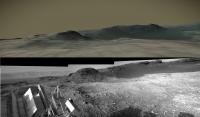
Montage of sol 1366 images featuring what could be 'Omulonga'. R-MastCam/RMI mosaic/NavCam
Curiosity Mission Update by Lauren Edgar, dated 10 Jun 2016 - Sols 1368-1370: On the road again QUOTE We received the engineering data that we needed to proceed with the final science activities at the Oudam drill site. Todays plan is focused on analyzing the pre-sieve dump pile and getting on the road again.
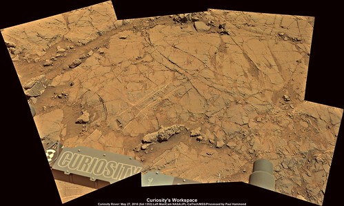
The three-sol plan starts by moving the arm out of the way so we can target the workspace. First well acquire a ChemCam passive observation on the pre-sieve dump pile, followed by several ChemCam and Mastcam observations of nearby veins. Then well use all of the Mastcam filters to study the DRT target Aubures, and well acquire a Mastcam mosaic to document the local geology. Well also target two areas to look for changes and the movement of fine-grained material. Then well move the arm back to the dump pile for MAHLI and APXS observations. On the second sol well use ChemCam to target the dump pile, and then well drive away. Well take our standard post-drive imaging, and an autonomously selected ChemCam target. The third sol is devoted to ChemCam and Mastcam observations to monitor the chemistry and opacity of the atmosphere. |
|
|
|
|
|
|
Jun 12 2016, 08:53 PM
Post
#56
|
|
|
Senior Member Group: Members Posts: 2429 Joined: 30-January 13 From: Penang, Malaysia. Member No.: 6853 |
Just in case you hadn't noticed, Curioity's Midnight Planets page is not loading the latest images. I messaged Michael, and he is away until next Sunday when things should return to normal
|
|
|
|
|
Jun 13 2016, 01:00 AM
Post
#57
|
||
|
Senior Member Group: Members Posts: 2429 Joined: 30-January 13 From: Penang, Malaysia. Member No.: 6853 |
Sol 1357/1368 comparison:
Looking for changes and the movement of fine-grained materials link to plan
|
|
|
|
|
|
|
Jun 13 2016, 04:25 AM
Post
#58
|
|
|
Senior Member Group: Members Posts: 4247 Joined: 17-January 05 Member No.: 152 |
Yeah, that was very close to the drill site as this wider navcam view shows:
http://mars.jpl.nasa.gov/msl-raw-images/pr...NCAM00309M_.JPG |
|
|
|
|
Jun 13 2016, 07:28 AM
Post
#59
|
||
|
Senior Member Group: Members Posts: 2429 Joined: 30-January 13 From: Penang, Malaysia. Member No.: 6853 |
Sol 1369 drive by Curiosity, drive details currently unknown with only a selection of NavCams available, so here is a quick and dirty end-of drive stitch (MS ICE)
Hope this can help to narrow down the location Cropped to bring it within the upload limit.
|
|
|
|
|
|
|
Jun 13 2016, 04:03 PM
Post
#60
|
||
|
Solar System Cartographer Group: Members Posts: 10164 Joined: 5-April 05 From: Canada Member No.: 227 |
Thanks Paul - I am completely reliant on our benefactors here on UMSF for panoramas.
It did give a good location. Here's a reprojection, made at my B&B in Lyme Regis, Dorset while supposedly on holiday. Phil
-------------------- ... because the Solar System ain't gonna map itself.
Also to be found posting similar content on https://mastodon.social/@PhilStooke Maps for download (free PD: https://upload.wikimedia.org/wikipedia/comm...Cartography.pdf NOTE: everything created by me which I post on UMSF is considered to be in the public domain (NOT CC, public domain) |
|
|
|
|
|
|
Jun 13 2016, 04:17 PM
Post
#61
|
|
|
Member Group: Members Posts: 923 Joined: 10-November 15 Member No.: 7837 |
Here is a 3D model of Curi in situ on Sol 1357, scaled to HiRISE image of visit to Namib. Model includes notional route ahead.
This link will take you to the model on Sketchfab... Overview of Curi at Murray Buttes 
-------------------- |
|
|
|
|
Jun 13 2016, 09:07 PM
Post
#62
|
|
|
Senior Member Group: Members Posts: 2429 Joined: 30-January 13 From: Penang, Malaysia. Member No.: 6853 |
QUOTE (Phil Stooke @ Jun 14 2016, 12:03 AM) Thanks Paul - I am completely reliant on our benefactors here on UMSF for panoramas. It did give a good location. Here's a reprojection, made at my B&B in Lyme Regis, Dorset while supposedly on holiday. Thanks for the reprojection and the new location map. Lyme Regis is a beautiful part of my old country. Hope you get chance to spend a little time at the 'Jurassic Coast' during your 'holiday' |
|
|
|
|
Jun 13 2016, 09:11 PM
Post
#63
|
|
|
Senior Member Group: Members Posts: 2429 Joined: 30-January 13 From: Penang, Malaysia. Member No.: 6853 |
QUOTE (Sean @ Jun 14 2016, 12:17 AM) Here is a 3D model of Curi in situ on Sol 1357, scaled to HiRISE image of visit to Namib. Model includes notional route ahead. Really impressed with this Sean... Some breathtaking scenery lies ahead, and now I have a sense of the topography that the rover will travel through, I'm looking forward to the journey even more
|
|
|
|
|
Jun 13 2016, 09:14 PM
Post
#64
|
|
 Member Group: Members Posts: 700 Joined: 3-December 04 From: Boulder, Colorado, USA Member No.: 117 |
Well that's bizarre- I'm also on holiday in Lyme Regis. Haven't run into Phil, though, and I'm leaving early in the morning.
John |
|
|
|
|
Jun 13 2016, 10:01 PM
Post
#65
|
|
|
Solar System Cartographer Group: Members Posts: 10164 Joined: 5-April 05 From: Canada Member No.: 227 |
Hi John! I leave tomorrow too.
Phil -------------------- ... because the Solar System ain't gonna map itself.
Also to be found posting similar content on https://mastodon.social/@PhilStooke Maps for download (free PD: https://upload.wikimedia.org/wikipedia/comm...Cartography.pdf NOTE: everything created by me which I post on UMSF is considered to be in the public domain (NOT CC, public domain) |
|
|
|
|
Jun 14 2016, 11:19 AM
Post
#66
|
||
|
Senior Member Group: Members Posts: 2429 Joined: 30-January 13 From: Penang, Malaysia. Member No.: 6853 |
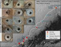
JPL have issued PIA20748 on its Photojournal page, it presents information relating to Curiosity's first 14 rock / soil sampling sites which are shown on a full traverse map.
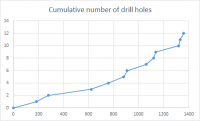
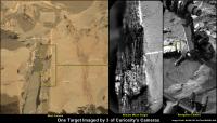
I have attached the 'modest' version of the image. The full size image is available on this link and the catalog page: PIA20748 In addition to dates and site reference numbers for the activities, they have also provided the elevation data for the first 11 drill sites. I can't recall seeing that data in a release before, so it may be of interest to those who follow Curiosity's ongoing journey They also released 2 versions of the recent MAHLI self portrait at the 'Okoruso' drill site: see PIA20602 and PIA20603
|
|
|
|
|
|
|
Jun 14 2016, 01:16 PM
Post
#67
|
|
|
Senior Member Group: Members Posts: 2346 Joined: 7-December 12 Member No.: 6780 |
Nice synopsis of the drill holes!
The Oudam drill tailings look tinted to reddish, as a hint to a few percent of hematite abundance, again, and presumedly low in clay minerals. |
|
|
|
|
Jun 14 2016, 02:35 PM
Post
#68
|
||
|
Senior Member Group: Members Posts: 2831 Joined: 22-April 05 From: Ridderkerk, Netherlands Member No.: 353 |
The complete Navcam L view on Sol 1369.
Jan van Driel
|
|
|
|
|
|
|
Jun 14 2016, 05:23 PM
Post
#69
|
||
|
Solar System Cartographer Group: Members Posts: 10164 Joined: 5-April 05 From: Canada Member No.: 227 |
Thanks, Jan - here is a circular version, giving a good view of the surroundings.
And... where am I today? Eype's Mouth. It's where part of Broadchurch was filmed. Phil
-------------------- ... because the Solar System ain't gonna map itself.
Also to be found posting similar content on https://mastodon.social/@PhilStooke Maps for download (free PD: https://upload.wikimedia.org/wikipedia/comm...Cartography.pdf NOTE: everything created by me which I post on UMSF is considered to be in the public domain (NOT CC, public domain) |
|
|
|
|
|
|
Jun 14 2016, 06:05 PM
Post
#70
|
||
|
Senior Member Group: Members Posts: 4247 Joined: 17-January 05 Member No.: 152 |
Phil route map for sol 1371:
The locations are probably good to within a couple of km, but the route is a complete guess until we can spot his tracks. Closeup maps with activities are pending...  
|
|
|
|
|
|
|
Jun 14 2016, 06:53 PM
Post
#71
|
|
|
Solar System Cartographer Group: Members Posts: 10164 Joined: 5-April 05 From: Canada Member No.: 227 |
Genius! But you're in the wrong thread...
Phil -------------------- ... because the Solar System ain't gonna map itself.
Also to be found posting similar content on https://mastodon.social/@PhilStooke Maps for download (free PD: https://upload.wikimedia.org/wikipedia/comm...Cartography.pdf NOTE: everything created by me which I post on UMSF is considered to be in the public domain (NOT CC, public domain) |
|
|
|
|
Jun 14 2016, 10:02 PM
Post
#72
|
||
|
Senior Member Group: Members Posts: 2429 Joined: 30-January 13 From: Penang, Malaysia. Member No.: 6853 |
Curiosity Mission Update by Lauren Edgar, dated 13 Jun 2016, Sols 1371-1372: Driving south
QUOTE The weekend drive went well, and Curiosity drove ~ 32 m to the south. This southward path will eventually take us through a gap in the active sand dunes that will be easier for Curiosity to traverse. Were planning another drive today, which will take us in the direction of the above Navcam image. Todays two-sol plan consists of several ChemCam and Mastcam observations of the Murray formation to assess variations in texture and chemistry. We also planned a small Mastcam mosaic to document some nearby cross-stratification and nodules, and a small MAHLI mosaic of the target Berg Aukas before driving away. After the drive, well acquire our standard set of post-drive imaging for context and targeting. The second sol includes a small untargeted science block, which we filled with a ChemCam autonomously selected target and a Mastcam observation to monitor the opacity of the atmosphere.
|
|
|
|
|
|
|
Jun 15 2016, 02:58 PM
Post
#73
|
||
|
Senior Member Group: Members Posts: 2429 Joined: 30-January 13 From: Penang, Malaysia. Member No.: 6853 |
As planned a drive on sol 1371, only have a partial pan so far (cropped to fit)
MP still down, but Mr Knapp's page shows SSE by around 30 meters Hope this helps narrow down the location until Jan can post the full pan. Meanwhile its back to Falcon 9
|
|
|
|
|
|
|
Jun 15 2016, 03:59 PM
Post
#74
|
|
|
Solar System Cartographer Group: Members Posts: 10164 Joined: 5-April 05 From: Canada Member No.: 227 |
Alas, I think I need the Full Monty (AKA a 360 degree pan) to get this one.
Phil, now in Abbotsbury and quite exhausted. -------------------- ... because the Solar System ain't gonna map itself.
Also to be found posting similar content on https://mastodon.social/@PhilStooke Maps for download (free PD: https://upload.wikimedia.org/wikipedia/comm...Cartography.pdf NOTE: everything created by me which I post on UMSF is considered to be in the public domain (NOT CC, public domain) |
|
|
|
|
Jun 15 2016, 08:46 PM
Post
#75
|
|
|
Member Group: Members Posts: 923 Joined: 10-November 15 Member No.: 7837 |
-------------------- |
|
|
|
|
Jun 15 2016, 11:20 PM
Post
#76
|
|
|
Senior Member Group: Members Posts: 2429 Joined: 30-January 13 From: Penang, Malaysia. Member No.: 6853 |
The full 360 pano, sol 1371 R-MastCam (MS ICE C/W the usual errors)
 Flickr 1024x239 Flickr 8192x1915 EDIT Curiosity Mission Update by Ken Herkenhoff, dated 15 Jun 2016, Sols 1373-1374: No touch, just go! QUOTE The 32-meter Sol 1371 drive completed exactly as planned, giving the rover a good view of the path toward the south. So another ~30-meter drive is planned for Sol 1373, after some remote science observations. We had the option of using the DRT and taking MAHLI images of the brush spot before the drive, but the science team decided to acquire more remote science observations rather than brushing the Stimson Formation bedrock reachable by the arm. Mastcam will image the path ahead through all spectral filters, then ChemCam and the Right Mastcam will observe Stimson bedrock targets "Sesfontein" and "Swartbooisdrif." The Right Mastcam will image the ChemCam target that was autonomously selected by the AEGIS software on Sol 1371, and a Left Mastcam mosaic of a fracture zone west of the rover is planned. On Sol 1374, AEGIS will be used to autonomously acquire another ChemCam observation and the Left Mastcam will take a 3x2 mosaic of the same area.
|
|
|
|
|
Jun 16 2016, 08:35 PM
Post
#77
|
||
|
Solar System Cartographer Group: Members Posts: 10164 Joined: 5-April 05 From: Canada Member No.: 227 |
Now I can locate the rover! Here is a circular view of Paul's panorama. We are on top of a little cliff which looks dramatic in HiRISE (see map) but is invisible here because of the lighting.
As for my traverse of the Jurassic Coast - I'm in Weymouth, last day of my trip and time to head back to Salisbury tomorrow. Phil
-------------------- ... because the Solar System ain't gonna map itself.
Also to be found posting similar content on https://mastodon.social/@PhilStooke Maps for download (free PD: https://upload.wikimedia.org/wikipedia/comm...Cartography.pdf NOTE: everything created by me which I post on UMSF is considered to be in the public domain (NOT CC, public domain) |
|
|
|
|
|
|
Jun 17 2016, 04:10 AM
Post
#78
|
||
|
Member Group: Members Posts: 923 Joined: 10-November 15 Member No.: 7837 |
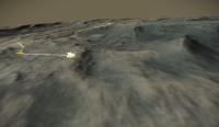
Here is an updated model showing Curi's current location, utilising Phil's mapping.
Sketchfab: Crossing the Dunes at Murray Buttes I've made a number of improvements to improve fidelity and performance.
Attached thumbnail(s)
-------------------- |
|
|
|
|
|
|
Jun 17 2016, 01:34 PM
Post
#79
|
|
|
Member Group: Members Posts: 923 Joined: 10-November 15 Member No.: 7837 |
Sol 1373 NR 360...
 All sizes Is it me or did Flickr just now support 2:1 panoramas? The image popped up already warped and rotating! And for fun, the 3D version, with the usual stereo errors, but the view is so nice!  All sizes -------------------- |
|
|
|
|
Jun 17 2016, 02:20 PM
Post
#80
|
||
|
Senior Member Group: Members Posts: 2831 Joined: 22-April 05 From: Ridderkerk, Netherlands Member No.: 353 |
Here is my view of the Sol 1373 NL B panorama.
Jan van Driel.
|
|
|
|
|
|
|
Jun 17 2016, 06:19 PM
Post
#81
|
||
|
Solar System Cartographer Group: Members Posts: 10164 Joined: 5-April 05 From: Canada Member No.: 227 |
Thanks, Jan, and here it is in a circular version.
Phil
-------------------- ... because the Solar System ain't gonna map itself.
Also to be found posting similar content on https://mastodon.social/@PhilStooke Maps for download (free PD: https://upload.wikimedia.org/wikipedia/comm...Cartography.pdf NOTE: everything created by me which I post on UMSF is considered to be in the public domain (NOT CC, public domain) |
|
|
|
|
|
|
Jun 18 2016, 06:48 AM
Post
#82
|
|
|
Senior Member Group: Members Posts: 2429 Joined: 30-January 13 From: Penang, Malaysia. Member No.: 6853 |
Curiosity Mission Update by Ken Herkenhoff, Dated 17 June 2016 Sols 1375-1377: Another busy weekend
QUOTE The Sol 1373 drive completed successfully, moving the rover over 31 meters toward the south. There's lots of bedrock exposed around the vehicle, but no flat patches large enough to brush in the arm workspace. So MAHLI will take images of an unbrushed target called "Andara" before the APXS is placed on it for an overnight integration. Before these arm activities on Sol 1375, ChemCam and the Right Mastcam will observe Andara and other bedrock targets "Okoloti," "Kalkfeld," and "Khorixas." Mastcam will then acquire a stereo mosaic of a nice outcrop toward the southwest dubbed "Baynes Mountains" and a left-eye mosaic of another outcrop northwest of the rover. The CheMin team requested another portion of the Oudam drill sample, which will be delivered late that afternoon. After dark, MAHLI will image the CheMin inlet using its LEDs for illumination.
Late in the morning of Sol 1376, APXS will integrate again on Andara to compare the quality of data acquired at different temperatures. Then the arm will be stowed for a long (about 55 meters) drive, which will be followed by the usual post-drive imaging and another ChemCam AEGIS (autonomously-targeted) observation. On Sol 1377, the Left Mastcam will acquire a mosaic of the rover deck, to serve as a baseline for comparison with future images taken after passing the sand dunes along the path ahead. Sand blown across the rover might remove some of the dust on the rover deck. Finally, CheMin will analyze the new Oudam sample portion overnight. It should be another busy weekend for MSL! |
|
|
|
|
Jun 19 2016, 03:45 AM
Post
#83
|
|
|
Senior Member Group: Members Posts: 2429 Joined: 30-January 13 From: Penang, Malaysia. Member No.: 6853 |
For those of you who have missed it as much as I have... Midnight Planets is back up to speed
|
|
|
|
|
Jun 19 2016, 12:56 PM
Post
#84
|
|
|
Senior Member Group: Members Posts: 2429 Joined: 30-January 13 From: Penang, Malaysia. Member No.: 6853 |
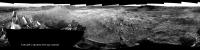
125 frame, L-MastCam panorama (sol 1367) MS ICE with no additional processing
 Flickr 1600x340 Flickr 2048x435 Flickr full size 29762x6322 |
|
|
|
|
Jun 20 2016, 04:31 AM
Post
#85
|
||
|
Senior Member Group: Members Posts: 2429 Joined: 30-January 13 From: Penang, Malaysia. Member No.: 6853 |
Sol 1376 End of Drive partial L-NavCam mosaic. At first glance it does not feel like the planned 55 meters, but this may give a few clues as to the distance / location. Low(ish) resolution to keep under the page limit. Stitched in MS ICE with the usual errors.
EDIT: Midnight Planets 'reported 'Curiosity moved approximately 17.3m S (176º) on Sol 1376' |
|
|
|
|
|
|
Jun 20 2016, 09:50 AM
Post
#86
|
||
|
Solar System Cartographer Group: Members Posts: 10164 Joined: 5-April 05 From: Canada Member No.: 227 |
It does help! Here is a semicircular version:
That dark marking to the southwest (north approx. at top as always in these projections of mine) is easy to find in HiRISE. This point is just about at the 13 km mark of the traverse. Phil -------------------- ... because the Solar System ain't gonna map itself.
Also to be found posting similar content on https://mastodon.social/@PhilStooke Maps for download (free PD: https://upload.wikimedia.org/wikipedia/comm...Cartography.pdf NOTE: everything created by me which I post on UMSF is considered to be in the public domain (NOT CC, public domain) |
|
|
|
|
|
|
Jun 20 2016, 11:48 AM
Post
#87
|
|
|
Member Group: Members Posts: 923 Joined: 10-November 15 Member No.: 7837 |
Paul, I took your view and did a quick compare with the HiRISE DTM for fun...
 ...prettay, prettay, prettay good! -------------------- |
|
|
|
|
Jun 20 2016, 11:58 AM
Post
#88
|
|
|
Senior Member Group: Members Posts: 2429 Joined: 30-January 13 From: Penang, Malaysia. Member No.: 6853 |
QUOTE (Sean @ Jun 20 2016, 07:48 PM) Paul, I took your view and did a quick compare with the HiRISE DTM for fun... ...prettay, prettay, prettay good! Well that works for me Nicely done Sean..... |
|
|
|
|
Jun 20 2016, 04:17 PM
Post
#89
|
|
 Senior Member Group: Members Posts: 1639 Joined: 5-March 05 From: Boulder, CO Member No.: 184 |
That's really neat with the 3-D modeling from HIRISE. For example it would be possible to make movies of the rover view of the past and future routes. The past routes can (and have been) enhanced with the Curiosity imagery.
-------------------- Steve [ my home page and planetary maps page ]
|
|
|
|
|
Jun 20 2016, 05:13 PM
Post
#90
|
|
|
Member Group: Members Posts: 923 Joined: 10-November 15 Member No.: 7837 |
Yes Herobrine has done some excellent work in that area but he is crunching seriously way more numbers than my mere computer and brain can manage.
The plan is to make a reasonably accessible 3D version of Curi's journey via Sketchfab with annotated links to panos etc along the way. Eventually hoping to host the whole journey over on JanusVR Curiosity Crossing the Dunes @ Murray Buttes -------------------- |
|
|
|
|
Jun 20 2016, 10:01 PM
Post
#91
|
||||
|
Member Group: Members Posts: 866 Joined: 15-March 05 From: Santa Cruz, CA Member No.: 196 |
that's really cool, i could lose my whole day playing around in that sandbox, though hard to get fine enough movement controls with such a large world size, perhaps the size maxed out here, but here is a sample compare (though my eyeballing probably didn't get sol1376 position that well) of that hummock on sol1376.. and stereo too..
|
|||
|
|
|
|||
|
Jun 20 2016, 11:09 PM
Post
#92
|
|
|
Member Group: Members Posts: 923 Joined: 10-November 15 Member No.: 7837 |
I'm hoping for some improvement in the sensitivity of moving around by experimenting with the scale of the imported model, although I suspect Sketchfab impose rigid constraints for what is allowed.
Don't forget that you can change navigation mode in the menu to first person and then change walking speed with the mouse wheel which gives you fine control over movement as well as looking great in VR. Having scouted the notional route ahead it appears we are in for some awesome vistas! Here is a 360 for Sol 1376... 
-------------------- |
|
|
|
|
Jun 21 2016, 07:43 AM
Post
#93
|
||
|
Solar System Cartographer Group: Members Posts: 10164 Joined: 5-April 05 From: Canada Member No.: 227 |
Thanks, Sean - here is a circular version.
Phil
-------------------- ... because the Solar System ain't gonna map itself.
Also to be found posting similar content on https://mastodon.social/@PhilStooke Maps for download (free PD: https://upload.wikimedia.org/wikipedia/comm...Cartography.pdf NOTE: everything created by me which I post on UMSF is considered to be in the public domain (NOT CC, public domain) |
|
|
|
|
|
|
Jun 22 2016, 02:22 AM
Post
#94
|
||
|
Senior Member Group: Members Posts: 2429 Joined: 30-January 13 From: Penang, Malaysia. Member No.: 6853 |
Curiosity Mission Update by Ryan Anderson: Dated 21 June 2016: Sol 1378-1379: Making up for lost distance:
QUOTE Over the weekend, the rover stopped after about 17 meters of the planned 65 meter drive. The rover is fine, the drive just tripped one of the (very conservative) limits on how the rovers suspension was expected to behave, causing Curiosity to stop and check in with Earth. Since there is nothing jumping out at us as a contact science target where we stopped, in todays plan we will try to make up for some of the lost distance from the weekend plan. In the Sol 1378 plan, ChemCam has observations of some bedrock at the target Tombua and a rock named Ai Ais. Mastcam then will image the two ChemCam targets, as well as the Sol 1376 AEGIS target. Mastcam will also image some veins at a location called Helgas. After that, we will drive and collect some typical post-drive imaging. On Sol 1379, we wont have data down from Sol 1378 yet, so it is an untargeted plan. In the morning, ChemCam, NavCam, and Mastcam have some atmospheric observations. Then in the afternoon, ChemCam has some calibration observations, followed by a few more Mastcam atmospheric observations.
|
|
|
|
|
|
|
Jun 22 2016, 08:24 AM
Post
#95
|
|
|
Senior Member Group: Members Posts: 2429 Joined: 30-January 13 From: Penang, Malaysia. Member No.: 6853 |
Midnight Planets reports that Curiosity moved approximately 42.7m S (-171º) on Sol 1378 - Link
I'll add one of my rough-n-ready pano's as soon as I have enough frames
|
|
|
|
|
Jun 22 2016, 05:12 PM
Post
#96
|
||
|
Senior Member Group: Members Posts: 2831 Joined: 22-April 05 From: Ridderkerk, Netherlands Member No.: 353 |
The Navcam L view on Sol 1378.
Jan van Driel
|
|
|
|
|
|
|
Jun 22 2016, 06:59 PM
Post
#97
|
||
|
Solar System Cartographer Group: Members Posts: 10164 Joined: 5-April 05 From: Canada Member No.: 227 |
Here's a quick circular version of that pan - thanks, Jan. This gives a really nice depiction of our location near those big drifts.
Phil
-------------------- ... because the Solar System ain't gonna map itself.
Also to be found posting similar content on https://mastodon.social/@PhilStooke Maps for download (free PD: https://upload.wikimedia.org/wikipedia/comm...Cartography.pdf NOTE: everything created by me which I post on UMSF is considered to be in the public domain (NOT CC, public domain) |
|
|
|
|
|
|
Jun 22 2016, 11:41 PM
Post
#98
|
|
|
Member Group: Members Posts: 923 Joined: 10-November 15 Member No.: 7837 |
Sol 1375 MR crop
 -------------------- |
|
|
|
|
Jun 23 2016, 06:10 AM
Post
#99
|
|
|
Senior Member Group: Members Posts: 2429 Joined: 30-January 13 From: Penang, Malaysia. Member No.: 6853 |
|
|
|
|
|
Jun 23 2016, 11:10 AM
Post
#100
|
||
|
Senior Member Group: Members Posts: 2429 Joined: 30-January 13 From: Penang, Malaysia. Member No.: 6853 |
Curiosity Mission Update by Lauren Edgar: Dated 22 June 2016: Sols 1380-1381: Contact Science at Koes
QUOTE The drive on Sol 1378 went well, and Curiosity drove ~44 m to the south, bringing our total drive distance to more than 13.2 km. Were currently making our way through a gap in the Bagnold dunes (part of a dune is visible in the upper left of the drive direction Navcam frame, above). Todays two-sol plan includes targeted remote sensing, and contact science at a target named Koes. Weve been searching for a good place to do contact science on the Murray formation around here, and there wont be enough power or time to fit contact science in the weekend plan, so its great to pick it up here. The plan starts with ChemCam and Mastcam observations of Koes and Onawa to characterize the Murray formation. Then well use the DRT to brush off a fresh surface at Koes, followed by MAHLI imaging. Well also use MAHLI to image the rover wheels, as part of our ongoing monitoring. Then well place APXS for an overnight integration on Koes. Well also carry out a SAM preconditioning activity, which heats up a sample cup in preparation for solid sample analysis. Curiosity will wake up early the next morning to acquire a Mastcam mosaic of Baynes Mountain to document the contact between the Murray and Stimson formations. On Sol 1381, well acquire another ChemCam observation of the Murray formation at Khoabendus, and well use Mastcam to characterize veins at the target Helgas. Then Navcam will be used to monitor the atmosphere and search for dust devils.
|
|
|
|
|
|
 |

|
Lo-Fi Version | Time is now: 19th May 2024 - 02:32 PM |
|
RULES AND GUIDELINES Please read the Forum Rules and Guidelines before posting. IMAGE COPYRIGHT |
OPINIONS AND MODERATION Opinions expressed on UnmannedSpaceflight.com are those of the individual posters and do not necessarily reflect the opinions of UnmannedSpaceflight.com or The Planetary Society. The all-volunteer UnmannedSpaceflight.com moderation team is wholly independent of The Planetary Society. The Planetary Society has no influence over decisions made by the UnmannedSpaceflight.com moderators. |
SUPPORT THE FORUM Unmannedspaceflight.com is funded by the Planetary Society. Please consider supporting our work and many other projects by donating to the Society or becoming a member. |
|