Endeavour Drive - Drivability analysis |

  |
Endeavour Drive - Drivability analysis |
 May 11 2009, 05:09 PM May 11 2009, 05:09 PM
Post
#841
|
|
|
Member  Group: Members Posts: 293 Joined: 22-September 08 From: Spain Member No.: 4350 |
|
 |
 
|
| Guest_Bobby_* |
Jun 11 2009, 12:40 AM
Post
#842
|
|
Guests |
In the latest Mars Exploration Rover Update at The J.P.L. Site dated June 9.
Ashley Stroupe says in the next 2 weeks they need to make a decision on 2 paths for Opportunity to get to Endeavour Crater. Path 1 is the shorter route with taller sand ripples & Path 2 is the longer route with smaller ripples. If they do the shorter path. When will we start heading that way and can anyone predict when this might start and where we might make that turn??? From the maps I have seen. I think we know what the longer path is. On SOL 1899 we hit the 10 mile mark  Here is the link to the Update: http://jpl.nasa.gov/video/index.cfm?id=843 |
|
|
|
|
Jun 11 2009, 08:11 AM
Post
#843
|
|
 Senior Member Group: Moderator Posts: 2262 Joined: 9-February 04 From: Melbourne - Oz Member No.: 16 |
The impression I got was the 'short' path would be something like my prediction the 'long' path would scoot around the west side of the large ripple patch we are approaching.
That would take us off the current HiRISE image - does anyone know if there is a HiRISE image further west that I could ripple map 
-------------------- |
|
|
|
|
Jun 11 2009, 11:07 AM
Post
#844
|
|
|
Senior Member Group: Moderator Posts: 4279 Joined: 19-April 05 From: .br at .es Member No.: 253 |
I found this one (ESP_011765_1780) via Google Earth. On the selection box at the left you should check "Spacecraft Imagery" > "HiRISE Image Browser" and the outline of the images will show up. This image has a lot of overlap with the current one (PSP_009141_1780) but covers some terrain to the left.
This site should be useful too. |
|
|
|
|
Jun 11 2009, 05:53 PM
Post
#845
|
|
|
Member Group: Members Posts: 530 Joined: 21-March 06 From: Canada Member No.: 721 |
You know, I've always suspected that applications would be more useful to me if I would just take the time to RTFM.
 That new view shows that the really nice ripple free terrain extends due south of Oppy. That certainly makes the westward route even more appealing. Apart from one tricky patch, it looks like fairly easy trough driving along the western edge to get to it. Not having to go cross-ripple for the eastern leg could make up time-wise the added distance. |
|
|
|
|
Jun 11 2009, 06:52 PM
Post
#846
|
|
|
Member Group: Members Posts: 128 Joined: 28-October 08 From: Boston, MA Member No.: 4469 |
I have to admit I can't see any advantage to going west around the large ripples. It looks like we would have to go considerably out of our way to avoid them safely. BrianL indicates that there is one "tricky patch", but it doesn't look to be any easier or shorter than the tricky patch we've got awaiting us to the southeast right now. The westward route may add a lot of good terrain to the journey, but it doesn't seem to remove much bad terrain. And making the trip any longer than it needs to be has to be considered a meaningful risk.
Has anyone tried mapping a tentative westward route yet? It would really help visualize what the trade-offs are if we could see some educated guesses mapped onto the HiRISE images. Mike |
|
|
|
|
Jun 11 2009, 08:58 PM
Post
#847
|
||
|
Member Group: Members Posts: 530 Joined: 21-March 06 From: Canada Member No.: 721 |
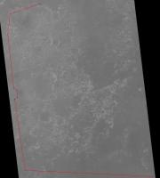
OK, here's my lame attempt at the route I envision. The jog around the "tricky part" doesn't need to be as dramatic as they way I've drawn it I'm sure. To my eye, that bottom east leg screams 200 m drives (well, but for that pesky wheel current thing). |
|
|
|
|
|
|
Jun 12 2009, 04:58 PM
Post
#848
|
|
|
Member Group: Senior Member Posts: 136 Joined: 8-August 06 Member No.: 1022 |
QUOTE (jamescanvin @ Jun 11 2009, 12:11 AM)  The impression I got was the 'short' path would be something like my prediction the 'long' path would scoot around the west side of the large ripple patch we are approaching. That would take us off the current HiRISE image - does anyone know if there is a HiRISE image further west that I could ripple map Yes, ESP_011765_1780 and ESP_012820_1780 extend to the west of the PSP_009141_1780 image that I've been using for my own route maps. 9141 is great because, though it's not the sharpest image of the landing site, it has the lowest emission angle of all the HiRISE images so far, so there's minimal distortion due to high-frequency topography at the scales relevant to the rover route planning. The other two images have high emission angles, because they were acquired for high resolution stereo of the path ahead (something greater than 30°). Of these, 12820 is less dusty than 11785, so I'm adding these two to my route map with 12820 overlying 11785. 11785 extends slightly farther west than 12820, which is why I'm including it in my mosaic (in the off chance we need to go that far west around the Purgatory fields or triangulate to features in that direction from the rover). planetarily, -Tim. |
|
|
|
|
Jun 12 2009, 05:45 PM
Post
#849
|
|
|
Member Group: Members Posts: 128 Joined: 28-October 08 From: Boston, MA Member No.: 4469 |
Thanks for posting that, BrianL. Crude though it may be, it gives me an idea of what the scope and range of the westward route would be. I was thinking they could probably cut to the east a couple km farther north, just past the rough patch that you indicate. Either way though, we're probably looking at an additional 2 to 5 km added to the journey. It may also preclude the possibility of stopping at "mini Endurance" crater, depending on where the turn is made.
It still seems to me that the best chance to turn south and east is now. The RP's have negotiated challenging terrain before, and I'm confident that they could pick a safe path through the upcoming rough patch. I would also expect the shorter route to maximize the opportunities for resting that RF wheel, which is clearly a priority at this point. Of course my own experience in driving robots on other planets is somewhat meager, so I'll just wait and see what the experts decide... |
|
|
|
|
Jun 12 2009, 07:40 PM
Post
#850
|
|
|
Member Group: Members Posts: 530 Joined: 21-March 06 From: Canada Member No.: 721 |
My suggested path is certainly very roughly plotted and likely overly cautious. I'm approaching it from the standpoint of minimizing stress on the wheel. To me, this would mean keeping the ripple size small (further west, smaller ripples) and in following the troughs till they are clear of them. I'm sure a healthy 6-wheeled rover could make it either way without problem. Perhaps the deciding factor in this decision will be which course offers them the best chance should the RF wheel lock up.
|
|
|
|
|
Jun 14 2009, 05:15 AM
Post
#851
|
||
 Member Group: Members Posts: 813 Joined: 8-February 04 From: Arabia Terra Member No.: 12 |
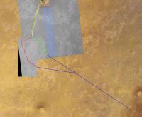
I've created a couple of kml files showing where I think the eastward and westward routes might go. Yellow line in the image is Tesheiner's route map.
Attached thumbnail(s)
Attached File(s)
|
|
|
|
|
|
|
Jun 14 2009, 10:06 AM
Post
#852
|
|
|
Member Group: Members Posts: 235 Joined: 2-August 05 Member No.: 451 |
Nice map!
Why not go another km or so South to the end of the salt-flats, and then zig zag East on the path of Ridges? note: I don't know how to set up my computer to edit kml files, so I'm just describing it in words. Sorry. |
|
|
|
|
Jun 14 2009, 06:52 PM
Post
#853
|
|
|
Member Group: Members Posts: 279 Joined: 19-August 07 Member No.: 3299 |
Techniques to advance:
|
|
|
|
|
Jun 14 2009, 11:27 PM
Post
#854
|
||
|
Member Group: Members Posts: 813 Joined: 8-February 04 From: Arabia Terra Member No.: 12 |
QUOTE (antoniseb @ Jun 14 2009, 11:06 AM) Nice map! Why not go another km or so South to the end of the salt-flats, and then zig zag East on the path of Ridges? I may well add that route... once I finish filling the gaps in this!  I'm trying to make an extension of the Hirise coverage that is in sync with the existing frame, has enough resolution to see individual ripples, covers the terrain ahead only and is under 20MB in size. This is what I've done so far, should finish a few more bits on Monday/Tuesday and then I'll upload the kmz. It's annoying that I can't get perfect registration with both the existing Hirise image and the HRSC and MOLA data.
Attached thumbnail(s)
|
|
|
|
|
|
|
Jun 15 2009, 03:30 AM
Post
#855
|
|
|
Member Group: Members Posts: 530 Joined: 21-March 06 From: Canada Member No.: 721 |
Wow, I can see Oppy high-tailing as she bounds through the ripples, dust flying up into the air as she 6-wheel drifts into that turn east toward the prize. Yee-haw!!!!
My apologies to those of you who can't stand a little unrealistic anthropomorphizing.
|
|
|
|
|

|
Lo-Fi Version | Time is now: 27th April 2024 - 10:33 AM |
|
RULES AND GUIDELINES Please read the Forum Rules and Guidelines before posting. IMAGE COPYRIGHT |
OPINIONS AND MODERATION Opinions expressed on UnmannedSpaceflight.com are those of the individual posters and do not necessarily reflect the opinions of UnmannedSpaceflight.com or The Planetary Society. The all-volunteer UnmannedSpaceflight.com moderation team is wholly independent of The Planetary Society. The Planetary Society has no influence over decisions made by the UnmannedSpaceflight.com moderators. |
SUPPORT THE FORUM Unmannedspaceflight.com is funded by the Planetary Society. Please consider supporting our work and many other projects by donating to the Society or becoming a member. |
|