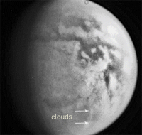
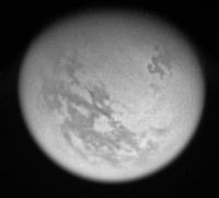
Cloud hunting between flybys, more distant views |

  |
Cloud hunting between flybys, more distant views |
 Feb 22 2009, 07:58 PM Feb 22 2009, 07:58 PM
Post
#16
|
||
 Senior Member  Group: Moderator Posts: 3233 Joined: 11-February 04 From: Tucson, AZ Member No.: 23 |
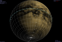
Here is a preview image with a grid:
Attached thumbnail(s)
-------------------- &@^^!% Jim! I'm a geologist, not a physicist!
The Gish Bar Times - A Blog all about Jupiter's Moon Io |
|
 |
 
|
|
|
Feb 22 2009, 09:11 PM
Post
#17
|
|
|
Member Group: Members Posts: 699 Joined: 1-April 08 From: Minnesota ! Member No.: 4081 |
Wow, awesome VP!
|
|
|
|
|
Feb 22 2009, 10:25 PM
Post
#18
|
|
|
Senior Member Group: Members Posts: 3516 Joined: 4-November 05 From: North Wales Member No.: 542 |
QUOTE (volcanopele @ Feb 22 2009, 07:58 PM)  Here is a preview image with a grid: That's very nice. Any chance that could be done on 'looking ahead'? AND Can you tell us whether that 9 hour cloud imaging campaign on 15th Feb. actually took place? There's still only the one set of 4 images on the public website. |
|
|
|
|
Feb 22 2009, 10:32 PM
Post
#19
|
|
|
Junior Member Group: Members Posts: 35 Joined: 28-September 05 From: Seattle, WA Member No.: 514 |
QUOTE (Juramike @ Feb 21 2009, 07:51 AM) Well, thanks for the tip. I installed it and now I can do lat/lon grids for everything but Titan. The problem might be as simple as the cloud layer obscuring the lat/lon grid. Try pressing 'i' to disable clouds. I've considered modifying Celestia's code a little so that the grid is displayed over the cloud layer. I'm not absolutely convinced that this is a good idea, as it could produce odd looking results for planets with a thin cloud layer (e.g. Mars.) Let me know what you think... --Chris |
|
|
|
|
Feb 22 2009, 11:19 PM
Post
#20
|
|
|
Senior Member Group: Moderator Posts: 3233 Joined: 11-February 04 From: Tucson, AZ Member No.: 23 |
QUOTE (ngunn @ Feb 22 2009, 03:25 PM) That's very nice. Any chance that could be done on 'looking ahead'? AND Can you tell us whether that 9 hour cloud imaging campaign on 15th Feb. actually took place? There's still only the one set of 4 images on the public website. Probably not. We are trying to make these look a bit cleaner, a bit more realistic if you will (though obviously, that isn't quite the case with Titan already). Rest assured though that I try to rotate so that north is up in any graphics I use in "Looking Ahead" And let's... not talk about that imaging campaign... we at least got those 4 images. And those 4 are quite good. But still. Titan hates me. It knows I cheated on it. -------------------- &@^^!% Jim! I'm a geologist, not a physicist!
The Gish Bar Times - A Blog all about Jupiter's Moon Io |
|
|
|
|
Feb 22 2009, 11:31 PM
Post
#21
|
|
 Senior Member Group: Moderator Posts: 2785 Joined: 10-November 06 From: Pasadena, CA Member No.: 1345 |
QUOTE (claurel @ Feb 22 2009, 05:32 PM) The problem might be as simple as the cloud layer obscuring the lat/lon grid. Try pressing 'i' to disable clouds. Oh..wow! That did the trick! And the surface features are revealed as well! Whoo-hoo! -------------------- Some higher resolution images available at my photostream: http://www.flickr.com/photos/31678681@N07/
|
|
|
|
|
Feb 22 2009, 11:41 PM
Post
#22
|
|
|
Member Group: Members Posts: 699 Joined: 1-April 08 From: Minnesota ! Member No.: 4081 |
QUOTE (claurel @ Feb 22 2009, 04:32 PM) The problem might be as simple as the cloud layer obscuring the lat/lon grid. Try pressing 'i' to disable clouds. I've considered modifying Celestia's code a little so that the grid is displayed over the cloud layer. I'm not absolutely convinced that this is a good idea, as it could produce odd looking results for planets with a thin cloud layer (e.g. Mars.) Let me know what you think... --Chris You are a genius CC! Pressing the i got rid of the clouds on Titan and there is the superimposed grid and surface. Now to get things aligned better. |
|
|
|
|
Feb 23 2009, 12:16 AM
Post
#23
|
|||
|
Senior Member Group: Moderator Posts: 2785 Joined: 10-November 06 From: Pasadena, CA Member No.: 1345 |
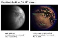
Here's a coordinated view between the Cassini Raw (contrast modified) and Celestia:
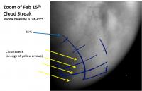
And here is a zoom using Photoshop (magnetic lasso is your friend) to select and detail some of the lat/lon grid:
The cloud streak runs from WNW to ESE. From roughly [-45S, 315W] to [-53, 285W] IIRC, the alignment of this cloud to Mezzoramia is about the same as the alignment of the N Polar cloud to Kraken Mare. Hmmmmm..... -Mike -------------------- Some higher resolution images available at my photostream: http://www.flickr.com/photos/31678681@N07/
|
||
|
|
|
||
|
Feb 23 2009, 01:17 AM
Post
#24
|
||
|
Senior Member Group: Moderator Posts: 2785 Joined: 10-November 06 From: Pasadena, CA Member No.: 1345 |
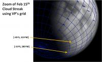
Here is another crop of a contrast-enhanced image, this time overlaid by VP's lat/lon grid (VP's posted image/grid rotated ca. 25 degrees clockwise):
(Elba Facula is centered near [-10S, 0]) -Mike -------------------- Some higher resolution images available at my photostream: http://www.flickr.com/photos/31678681@N07/
|
|
|
|
|
|
|
Mar 9 2009, 10:05 PM
Post
#25
|
|
|
Senior Member Group: Members Posts: 3516 Joined: 4-November 05 From: North Wales Member No.: 542 |
Kraken Mare again:
http://saturn.jpl.nasa.gov/photos/raw/rawi...?imageID=185908 |
|
|
|
|
Mar 20 2009, 12:00 PM
Post
#26
|
||
|
Member Group: Members Posts: 699 Joined: 1-April 08 From: Minnesota ! Member No.: 4081 |
QUOTE (ngunn @ Feb 22 2009, 12:57 PM) I think that grid needs rotating clockwise quite a bit. Well I know this is a bit late but I had to make ammends. Nice work by VP and Mike on previous page! The Celestia Titan grid-surface map is nice however when it comes to locating clouds there is likely to be an error as they are considerably above surface level! Hmmm. Note to editor: I cannot seem to upload my photoshop files anymore. Anyone else having trouble? Well that time things worked!
|
|
|
|
|
|
|
Mar 20 2009, 01:02 PM
Post
#27
|
|
|
Senior Member Group: Members Posts: 3516 Joined: 4-November 05 From: North Wales Member No.: 542 |
Another beautiful shot of the northern 'dark surface region' emerging from night (appropriately released on our own spring equinox).
http://saturn.jpl.nasa.gov/multimedia/imag...8/N00132269.jpg |
|
|
|
|
Mar 20 2009, 02:18 PM
Post
#28
|
||
|
Solar System Cartographer Group: Members Posts: 10153 Joined: 5-April 05 From: Canada Member No.: 227 |
Here's a bit of a stretch on that one...
Phil
-------------------- ... because the Solar System ain't gonna map itself.
Also to be found posting similar content on https://mastodon.social/@PhilStooke Maps for download (free PD: https://upload.wikimedia.org/wikipedia/comm...Cartography.pdf NOTE: everything created by me which I post on UMSF is considered to be in the public domain (NOT CC, public domain) |
|
|
|
|
|
|
Mar 20 2009, 09:59 PM
Post
#29
|
|
|
Senior Member Group: Members Posts: 3516 Joined: 4-November 05 From: North Wales Member No.: 542 |
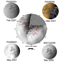
Thanks for that, Phil. The toe of Italy seems to be falling off. Maybe it was never that well attached? The discovery image of Kraken Mare is annotated with a rather inclusive shoreline despite some bright pixels inside the boundary.
http://upload.wikimedia.org/wikipedia/comm...Kraken_mare.jpg |
|
|
|
|
Mar 21 2009, 07:16 PM
Post
#30
|
||
|
Member Group: Members Posts: 699 Joined: 1-April 08 From: Minnesota ! Member No.: 4081 |
Nice work on this latest Titan image!
Kraken over the last several years appears not to have changed radically. (see images below). I wonder if it has been substantially maintained by the persisting ethane/methane rain clouds of the north pole region (PIA09171), from runoff via inflowing streams visualized in previous SARs (PIA09217) as well as from underground sources via sapping from methanofers. Its persistence may suggest its relatively deep if indeed its liquid.
|
|
|
|
|
|
|

|
Lo-Fi Version | Time is now: 28th April 2024 - 03:04 AM |
|
RULES AND GUIDELINES Please read the Forum Rules and Guidelines before posting. IMAGE COPYRIGHT |
OPINIONS AND MODERATION Opinions expressed on UnmannedSpaceflight.com are those of the individual posters and do not necessarily reflect the opinions of UnmannedSpaceflight.com or The Planetary Society. The all-volunteer UnmannedSpaceflight.com moderation team is wholly independent of The Planetary Society. The Planetary Society has no influence over decisions made by the UnmannedSpaceflight.com moderators. |
SUPPORT THE FORUM Unmannedspaceflight.com is funded by the Planetary Society. Please consider supporting our work and many other projects by donating to the Society or becoming a member. |
|