LCROSS en route |

  |
LCROSS en route |
 Oct 4 2009, 03:59 PM Oct 4 2009, 03:59 PM
Post
#46
|
|
|
Solar System Cartographer  Group: Members Posts: 10162 Joined: 5-April 05 From: Canada Member No.: 227 |
It's the image processing that's different.
Phil -------------------- ... because the Solar System ain't gonna map itself.
Also to be found posting similar content on https://mastodon.social/@PhilStooke Maps for download (free PD: https://upload.wikimedia.org/wikipedia/comm...Cartography.pdf NOTE: everything created by me which I post on UMSF is considered to be in the public domain (NOT CC, public domain) |
 |
 
|
|
Oct 4 2009, 04:59 PM
Post
#47
|
||
 Senior Member Group: Members Posts: 2173 Joined: 28-December 04 From: Florida, USA Member No.: 132 |
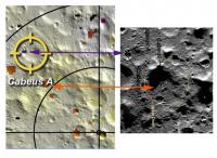
Here's the map comparison that interests me: The target and water concentration maps:
The purple pixels in the old target area indicate (possibly) 1.7% water, the orange pixels of the the new target indicate 1%. As I understand it, the lower concentration of water in the new target area is offset by better viewing of the results. I wonder if there was also a little discomfort in relying on a signal of two purple pixels as opposed to a genuine patch of orange. It seems to me that the new target is at the very edge of the orange patch. Perhaps that's the result of different viewing angles in the two images?
|
|
|
|
|
|
|
Oct 4 2009, 05:07 PM
Post
#48
|
|
|
Solar System Cartographer Group: Members Posts: 10162 Joined: 5-April 05 From: Canada Member No.: 227 |
Also the map of hydrogen concentrations is very model-dependent. The data were low resolution, and a model tries to show where it might be concentrated to give the blurry result actually observed. They will have better data now from LRO and other spacecraft, and that's probably what they preferred to use rather than the older model.
Phil -------------------- ... because the Solar System ain't gonna map itself.
Also to be found posting similar content on https://mastodon.social/@PhilStooke Maps for download (free PD: https://upload.wikimedia.org/wikipedia/comm...Cartography.pdf NOTE: everything created by me which I post on UMSF is considered to be in the public domain (NOT CC, public domain) |
|
|
|
|
Oct 4 2009, 05:18 PM
Post
#49
|
||
|
Solar System Cartographer Group: Members Posts: 10162 Joined: 5-April 05 From: Canada Member No.: 227 |
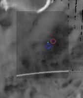
This is a comparison of the points John and I matched. They are very close but not exactly the same. I should point out that Tony Colaprete's circles don't reflect uncertainties. If they did they would not be the same size. The SSC uncertainty is about 3x greater due to the separation burn.
Phil
-------------------- ... because the Solar System ain't gonna map itself.
Also to be found posting similar content on https://mastodon.social/@PhilStooke Maps for download (free PD: https://upload.wikimedia.org/wikipedia/comm...Cartography.pdf NOTE: everything created by me which I post on UMSF is considered to be in the public domain (NOT CC, public domain) |
|
|
|
|
|
|
Oct 5 2009, 08:10 AM
Post
#50
|
|
|
Newbie Group: Members Posts: 16 Joined: 30-March 08 Member No.: 4078 |
QUOTE (centsworth_II @ Oct 5 2009, 05:59 AM)  As I understand it, the lower concentration of water in the new target area is offset by better viewing of the results. No, that's not true unfortunately. This document (http://www.nasa.gov/pdf/386497main_target-selection_web2.pdf) shows that the new target crater Caebus has *far* worse viewing conditions than Caebus A. Caebus A Sun Mask Height: 630m, Caebus A Earth Mask Height: 330m Caebus Sun Mask Height 1420m, Caebus Earth Mask Height 3070m This is quite bad news -- they're sacrificing a lot of water sensitivity due to the sunlight/Earth masking. There must have been something seriously wrong with Caebus A to warrant this, as the mask heights at Caebus A are absolutely perfect for an experiment like this. I'm guessing that new LRO data must have either indicated a very uneven distribution or lack of water in the old target. |
|
|
|
|
Oct 5 2009, 11:00 AM
Post
#51
|
|
|
Member Group: Members Posts: 156 Joined: 22-May 09 From: Ireland Member No.: 4792 |
@ Phil...ah yes...see what you mean, your points are certainly more precise -- I think I was more interested in the feature that the points were impacting upon....my apologies.
@ ADMIN....my apologies also to you...I wasn't aware that I was abusing the forum, or, that I had received a previous warning before your 'Final warning' issue. I have tried contributing where I thought necessary interest prevailed -- submitting relevant images and comments (all done with respect), however, it appears I am misguided. Might be better if I just observe from now on. Regards John ------------ With great power comes greater responsibility...sometimes |
|
|
|
|
Oct 5 2009, 11:16 AM
Post
#52
|
|
|
Solar System Cartographer Group: Members Posts: 10162 Joined: 5-April 05 From: Canada Member No.: 227 |
John, it's only the 'quote' business that is an issue. When you reply, click on 'add reply' at the bottom of the page instead of the 'quote reply' at the bottom of the specific message.
Phil (PS I'm not an ADMIN, just offering advice) -------------------- ... because the Solar System ain't gonna map itself.
Also to be found posting similar content on https://mastodon.social/@PhilStooke Maps for download (free PD: https://upload.wikimedia.org/wikipedia/comm...Cartography.pdf NOTE: everything created by me which I post on UMSF is considered to be in the public domain (NOT CC, public domain) |
|
|
|
|
Oct 5 2009, 03:34 PM
Post
#53
|
|
|
Senior Member Group: Members Posts: 2173 Joined: 28-December 04 From: Florida, USA Member No.: 132 |
QUOTE (JGodbaz @ Oct 5 2009, 03:10 AM) This document (http://www.nasa.gov/pdf/386497main_target-selection_web2.pdf) shows that the new target crater Caebus has *far* worse viewing conditions than Caebus A. The September 5 paper you link to has been superseded by a September 28 release. Based on new data, there are advantages both in certainty of hydrogen signal and viewing geometry for the new site. "The general consensus of lunar experts led by the LCROSS science team is that Cabeus shows, with the greatest level of certainty, the highest hydrogen concentrations at the south pole. Further consideration of the most current terrain models... was important in the decision process. The models show a small valley in an otherwise tall Cabeus perimeter ridge, which will allow for sunlight to illuminate the ejecta cloud on Oct. 9, and much sooner than previously estimated for Cabeus. While the ejecta does have to fly to higher elevations to be observed by Earth assets, a shadow cast by a large hill along the Cabeus ridge, provides an excellent, high-contrast, back drop for ejecta and vapor measurements." |
|
|
|
|
Oct 6 2009, 01:16 AM
Post
#54
|
|
|
Solar System Cartographer Group: Members Posts: 10162 Joined: 5-April 05 From: Canada Member No.: 227 |
It's hard to keep these maps up to date! Today's trajectory correction, TCM 9, moved the target 9 km - don't know where yet. See the Flight Director's blog at:
http://wiki.nasa.gov/cm/blog/lcrossfdblog/...4770098554.html Phil -------------------- ... because the Solar System ain't gonna map itself.
Also to be found posting similar content on https://mastodon.social/@PhilStooke Maps for download (free PD: https://upload.wikimedia.org/wikipedia/comm...Cartography.pdf NOTE: everything created by me which I post on UMSF is considered to be in the public domain (NOT CC, public domain) |
|
|
|
|
Oct 6 2009, 01:31 AM
Post
#55
|
|
|
Newbie Group: Members Posts: 16 Joined: 30-March 08 Member No.: 4078 |
Thanks, I wasn't aware of the new release.
I wouldn't say that there are any advantages to the viewing geometry over Caebus A though -- even with the valley the Earth mask height is still very poor and they didn't specify the actual sun mask height. It might be better than previous, but without a specific figure it could still be a lot worse than Caebus A and a similar backdrop could have as easily been present at the previous crater (Not trying to be argumentative or anything  , it's just hard to distill a lot of information from a normal press release). , it's just hard to distill a lot of information from a normal press release).
|
|
|
|
|
Oct 6 2009, 01:37 AM
Post
#56
|
|
|
Solar System Cartographer Group: Members Posts: 10162 Joined: 5-April 05 From: Canada Member No.: 227 |
If it was worse, would they have chosen it? They have far more information than we have.
These are the coords I have now: Cabeus_impact_Centaur 310.950 -84.770 -3.827 (as of 2009oct03) Cabeus_impact_SSC 310.450 -84.770 -3.8 (as of 2009oct03) (values are long, lat, LOLA elevation) source: http://groups.google.com/group/lcross_obse...dcfb743944c607f Phil -------------------- ... because the Solar System ain't gonna map itself.
Also to be found posting similar content on https://mastodon.social/@PhilStooke Maps for download (free PD: https://upload.wikimedia.org/wikipedia/comm...Cartography.pdf NOTE: everything created by me which I post on UMSF is considered to be in the public domain (NOT CC, public domain) |
|
|
|
|
Oct 6 2009, 01:42 AM
Post
#57
|
|
|
Newbie Group: Members Posts: 16 Joined: 30-March 08 Member No.: 4078 |
They don't have a lot of choice as there aren't a lot of good target craters with an adequate concentration of water and the ones with water don't necessarily have the best geometry. I'm not saying they haven't made the best decision possible, just that it doesn't look like an easy trade-off.
|
|
|
|
|
Oct 6 2009, 01:47 AM
Post
#58
|
|
|
Solar System Cartographer Group: Members Posts: 10162 Joined: 5-April 05 From: Canada Member No.: 227 |
I think you're right. I bet the site selection process looked like it would be a lot easier when the process started.
Phil -------------------- ... because the Solar System ain't gonna map itself.
Also to be found posting similar content on https://mastodon.social/@PhilStooke Maps for download (free PD: https://upload.wikimedia.org/wikipedia/comm...Cartography.pdf NOTE: everything created by me which I post on UMSF is considered to be in the public domain (NOT CC, public domain) |
|
|
|
|
Oct 6 2009, 03:06 AM
Post
#59
|
|
|
Member Group: Members Posts: 808 Joined: 10-October 06 From: Maynard Mass USA Member No.: 1241 |
impact is Oct 9, 7:30am-ish local time with the sun up here in Boston....don't think I going to see anything (sun rises at 6:50am).
West Coast Amateurs : you are our only hope! The LCROSS Centaur impact is scheduled for 4:31 a.m. PDT or 7:31 a.m. EDT (11:31 UTC) on October 9, 2009. The sheparding spacecraft will impact at 4:35 a.m. PDT or 7:35 a.m. EDT (11:35 UTC). Mission scientists estimate that the Centaur impact debris plume should be in view several seconds after Centaur impact and will peak in brightness at 30 to 100 seconds after impact. Lunar Impact Locations Centaur: -84.675, 311.275 E Shepherding spacecraft: -84.729, 310.64 E Time Zone Lighting Conditions for Viewing Eastern Daybreak will prevent viewing of the debris plumes. Central Best viewing is West of the Mississippi River. Mountain Excellent lighting conditions. Pacific Excellent lighting conditions. Alaska Excellent lighting conditions. Hawaii Excellent lighting conditions. cheers -------------------- CLA CLL
|
|
|
|
|
Oct 6 2009, 02:36 PM
Post
#60
|
|
|
Solar System Cartographer Group: Members Posts: 10162 Joined: 5-April 05 From: Canada Member No.: 227 |
Ahh, good old Social Media! Lots of entertainment as we await the impact.
The LCROSS Facebook page has been invaded by 'Don't bomb the Moon' types. I can't believe anyone is that stupid, so I am forced to think it's all a joke. They are sitting around laughing at the people who respond seriously, which makes serious responses a waste of time. (Most space hoax stuff is the same, hardly anyone really believes it, especially those at the root of it) Meanwhile... it's no longer active but there was a very funny - intentionally funny - Fake LCROSS twitter account (you can get to it just by googling 'fake lcross'). Fake LCROSS fretted about his (or her?) impending doom, hoping against hope that the launch would be cancelled due to bad weather or other problems. Meanwhile, LCROSS proper has been twittering all along, and very well too in my opinion. Very informative posts, good links, and frequent updates. I'm quite impressed with this approach to outreach. Phil -------------------- ... because the Solar System ain't gonna map itself.
Also to be found posting similar content on https://mastodon.social/@PhilStooke Maps for download (free PD: https://upload.wikimedia.org/wikipedia/comm...Cartography.pdf NOTE: everything created by me which I post on UMSF is considered to be in the public domain (NOT CC, public domain) |
|
|
|
|

|
Lo-Fi Version | Time is now: 16th May 2024 - 01:55 PM |
|
RULES AND GUIDELINES Please read the Forum Rules and Guidelines before posting. IMAGE COPYRIGHT |
OPINIONS AND MODERATION Opinions expressed on UnmannedSpaceflight.com are those of the individual posters and do not necessarily reflect the opinions of UnmannedSpaceflight.com or The Planetary Society. The all-volunteer UnmannedSpaceflight.com moderation team is wholly independent of The Planetary Society. The Planetary Society has no influence over decisions made by the UnmannedSpaceflight.com moderators. |
SUPPORT THE FORUM Unmannedspaceflight.com is funded by the Planetary Society. Please consider supporting our work and many other projects by donating to the Society or becoming a member. |
|