Apollo Sites from LRO |

  |
Apollo Sites from LRO |
 Sep 6 2009, 01:46 AM Sep 6 2009, 01:46 AM
Post
#211
|
||
|
Member  Group: Members Posts: 808 Joined: 10-October 06 From: Maynard Mass USA Member No.: 1241 |
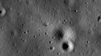
Here is the Apollo 11 site from LROC with a home brew de-striper and a try at an initial calibration.
It has been zoomed by 3X
cheers -------------------- CLA CLL
|
|
 |
 
|
|
|
Sep 6 2009, 02:32 AM
Post
#212
|
||
|
Member Group: Members Posts: 808 Joined: 10-October 06 From: Maynard Mass USA Member No.: 1241 |
Here is the processed Apollo 14 landing site
(destriped, rough cal)
Cheers -------------------- CLA CLL
|
|
|
|
|
|
|
Sep 6 2009, 02:50 AM
Post
#213
|
|
 Senior Member Group: Members Posts: 3419 Joined: 9-February 04 From: Minneapolis, MN, USA Member No.: 15 |
Nice work, PDP! In particular, the A14 image really shows the contours of the old, extremely subdued crater that Antares landed in. It's also obvious that all of the Triplet craters, even the subdued-itself North Triplet, are an awful lot younger than the old, extremely subdued craters, as North is directly superposed on the landing site crater's northeast rim.
-the other Doug -------------------- The trouble ain't that there is too many fools, but that the lightning ain't distributed right. -Mark Twain
|
|
|
|
|
Sep 6 2009, 03:11 AM
Post
#214
|
||
|
Member Group: Members Posts: 808 Joined: 10-October 06 From: Maynard Mass USA Member No.: 1241 |
Thanks Doug (as a fellow Apollo witness, these are truly good times)
Here is the Apollo 15 LROC site (same processing)
cheers -------------------- CLA CLL
|
|
|
|
|
|
|
Sep 6 2009, 03:15 AM
Post
#215
|
|
 Member Group: Members Posts: 753 Joined: 23-October 04 From: Greensboro, NC USA Member No.: 103 |
QUOTE (dvandorn @ Sep 5 2009, 10:50 PM)  Nice work, PDP! In particular, the A14 image really shows the contours of the old, extremely subdued crater that Antares landed in. It's also obvious that all of the Triplet craters, even the subdued-itself North Triplet, are an awful lot younger than the old, extremely subdued craters, as North is directly superposed on the landing site crater's northeast rim. -the other Doug It also appears to me that you can see the shadows of the RCS plume deflectors that were mounted on the descent stage. -------------------- Jonathan Ward
Manning the LCC at http://www.apollolaunchcontrol.com |
|
|
|
|
Sep 6 2009, 03:45 AM
Post
#216
|
||
|
Member Group: Members Posts: 808 Joined: 10-October 06 From: Maynard Mass USA Member No.: 1241 |
Here is the LROC Apollo 16 site (with the same processing)
cheers -------------------- CLA CLL
|
|
|
|
|
|
|
Sep 6 2009, 04:11 AM
Post
#217
|
||
|
Member Group: Members Posts: 808 Joined: 10-October 06 From: Maynard Mass USA Member No.: 1241 |
and here is the last ...Apollo 17 landing site for LROC (same processing)
cheers (and to bed!) -------------------- CLA CLL
|
|
|
|
|
|
|
Sep 6 2009, 12:04 PM
Post
#218
|
|
|
Senior Member Group: Members Posts: 2922 Joined: 14-February 06 From: Very close to the Pyrénées Mountains (France) Member No.: 682 |
QUOTE (PDP8E @ Sep 6 2009, 03:46 AM) Here is the Apollo 11 site from LROC with a home brew de-striper and a try at an initial calibration. cheers Incredible! We can even make the ladder's shadow on the right  Seriously, thank so much. -------------------- |
|
|
|
|
Sep 6 2009, 09:47 PM
Post
#219
|
|
 Member Group: Members Posts: 559 Joined: 1-May 06 From: Scotland (Ecosse, Escocia) Member No.: 759 |
Those images are astonishing. On A16, but also on A17 and possibly A14, you can actually see the 2 shadows of the thin blast deflectors from the RCS thrusters, which stand up from the descent stage at 2 corners. We know from the lunar lift-off TV on A15, 16 and 17 that these structures survived the blast from the departure of the LM ascent stage.
|
|
|
|
|
Sep 7 2009, 01:05 AM
Post
#220
|
||
|
Member Group: Members Posts: 808 Joined: 10-October 06 From: Maynard Mass USA Member No.: 1241 |
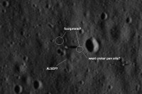
Here is an annotated image of the Apollo 11 landing site.
After processing and looking at the map of 'where things should be' at the site, I have annotated what I think are footprints and the location of the ALSEP. Now, as we get to a lower orbit and re-image I could be totally wrong, but still, I present them for your inspection and careful scrutiny.
your mileage may vary cheers -------------------- CLA CLL
|
|
|
|
|
|
|
Sep 7 2009, 07:30 AM
Post
#221
|
|
|
Member Group: Members Posts: 559 Joined: 1-May 06 From: Scotland (Ecosse, Escocia) Member No.: 759 |
That crater is actually Little West Crater, and the bigger West Crater is out of shot to the right. Confusingly, on some maps, Little West is actually called East Crater because it is east of the landing site. Armstrong's pan location was right on the rim, so a little east of where you mark it.
Your ALSEP looks about right for the PSE, but the LRRR was closer to the LM. Amazing if the actual PSE instrument is visible, which I think it is. This post mission A11 map has most of the features: Apollo Lunar Surface Journal - Apollo 11 traverse map |
|
|
|
|
Sep 9 2009, 11:50 PM
Post
#222
|
||
|
Solar System Cartographer Group: Members Posts: 10190 Joined: 5-April 05 From: Canada Member No.: 227 |
That Apollo 11 map is a bad copy of this original (USGS drawing, Defense Mapping Agency publication):
http://www.lpi.usra.edu/resources/mapcatal...ST/ap_11_12_14/ Using the same map as a source, in this image I have superimposed the Apollo 12 traverse on the LROC image (copied from one of the above posts) and attempted to map out in red the tracks we can see with LROC. In some areas it's not easy to see where the tracks are so there's some guesswork involved, but in many areas they are clear. More troubling, you can find linear markings - subtle topographic shading - in places that were never walked on, so care has to be taken in interpreting the faint trails. It shows where the traverse was reconstructed accurately and where it was not - the EVA mapping was based on debriefing done weeks after the events, and you can try mapping an off-trail hike from memory to see how difficult it is. One thing that never made it onto the EVA maps was a very quick run around at the end of EVA 2 in the general area north of the LM, using Tom Gold's Lunar Surface Close-Up Camera to take stereo images. Some of the tracks and spots north of the LM come from that. Phil
-------------------- ... because the Solar System ain't gonna map itself.
Also to be found posting similar content on https://mastodon.social/@PhilStooke Maps for download (free PD: https://upload.wikimedia.org/wikipedia/comm...Cartography.pdf NOTE: everything created by me which I post on UMSF is considered to be in the public domain (NOT CC, public domain) |
|
|
|
|
|
|
Sep 10 2009, 12:57 AM
Post
#223
|
|
|
Senior Member Group: Members Posts: 3419 Joined: 9-February 04 From: Minneapolis, MN, USA Member No.: 15 |
Ah, Phil... exquisite! And let me say, you're the only guy here I know of who would know to correctly identify Middle Crescent Crater.
 Now what I'm really looking forward to is seeing how well we can see Rover tracks on Hadley Delta, Stone Mountain and the North and South Massifs, and whether or not we can see sets of footprint tracks at the sampling stations at Hadley, Descartes and Taurus-Littrow. (The instance we do have, of Station 6 from A17, doesn't show much in terms of tracks of any kind, a fact which I'm tempted to attribute to the sun angle.) -the other Doug -------------------- The trouble ain't that there is too many fools, but that the lightning ain't distributed right. -Mark Twain
|
|
|
|
|
Sep 10 2009, 01:20 AM
Post
#224
|
||
|
Solar System Cartographer Group: Members Posts: 10190 Joined: 5-April 05 From: Canada Member No.: 227 |
Thanks, oDoug. Here's a look at another site, Apollo 17 Station 8 on the Sculptured Hills. Tracks are faintly visible if you know what to look for - this is located based on an original sketch in the USGS Professional paper on Apollo 17 and the derived version in my atlas. 'SWP' is a crater named after the 'Science Working Panel' (successor to GLEP, the Group for Lunar Exploration Planning) which defined science activities at the landing sites.
Phil
-------------------- ... because the Solar System ain't gonna map itself.
Also to be found posting similar content on https://mastodon.social/@PhilStooke Maps for download (free PD: https://upload.wikimedia.org/wikipedia/comm...Cartography.pdf NOTE: everything created by me which I post on UMSF is considered to be in the public domain (NOT CC, public domain) |
|
|
|
|
|
|
Sep 10 2009, 09:48 PM
Post
#225
|
|
|
Member Group: Members Posts: 559 Joined: 1-May 06 From: Scotland (Ecosse, Escocia) Member No.: 759 |
QUOTE (dvandorn @ Sep 10 2009, 01:57 AM) Ah, Phil... exquisite! And let me say, you're the only guy here I know of who would know to correctly identify Middle Crescent Crater. Hey, c'mon... he's not the only one familiar with Middle Crescent. I mentioned it in Post #185 . But I truly concur ... his work IS exquisite! |
|
|
|
|

|
Lo-Fi Version | Time is now: 8th June 2024 - 02:55 PM |
|
RULES AND GUIDELINES Please read the Forum Rules and Guidelines before posting. IMAGE COPYRIGHT |
OPINIONS AND MODERATION Opinions expressed on UnmannedSpaceflight.com are those of the individual posters and do not necessarily reflect the opinions of UnmannedSpaceflight.com or The Planetary Society. The all-volunteer UnmannedSpaceflight.com moderation team is wholly independent of The Planetary Society. The Planetary Society has no influence over decisions made by the UnmannedSpaceflight.com moderators. |
SUPPORT THE FORUM Unmannedspaceflight.com is funded by the Planetary Society. Please consider supporting our work and many other projects by donating to the Society or becoming a member. |
|