Rev 123 - Dec 18, 2009-Jan 3, 2010 - Prometheus |

 Unmanned Spaceflight.com > Outer Solar System > Saturn > Cassini Huygens > Cassini's ongoing mission and raw images
  |
Rev 123 - Dec 18, 2009-Jan 3, 2010 - Prometheus |
 Jan 4 2010, 10:39 PM Jan 4 2010, 10:39 PM
Post
#31
|
|
|
Junior Member  Group: Members Posts: 30 Joined: 30-May 05 Member No.: 396 |
QUOTE I'm still trying to deal with all these noise hits... darn you charged particles, why do you pain me so? It could have been much worse... Actually, Cassini data indicate that Saturn's radiation belts are much weaker than any other in our solar system. The moons and the rings material do a very good job in removing lots of this noise source for the images :-) |
 |
 
|
|
Jan 4 2010, 11:35 PM
Post
#32
|
|
|
Solar System Cartographer Group: Members Posts: 10153 Joined: 5-April 05 From: Canada Member No.: 227 |
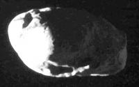
I didn't notice anyone else commenting on this - but the Prometheus images show the side opposite the best Voyager view, and north is at the top in the raws.
Phil -------------------- ... because the Solar System ain't gonna map itself.
Also to be found posting similar content on https://mastodon.social/@PhilStooke Maps for download (free PD: https://upload.wikimedia.org/wikipedia/comm...Cartography.pdf NOTE: everything created by me which I post on UMSF is considered to be in the public domain (NOT CC, public domain) |
|
|
|
|
Jan 5 2010, 03:35 AM
Post
#33
|
||
 Senior Member Group: Moderator Posts: 2785 Joined: 10-November 06 From: Pasadena, CA Member No.: 1345 |
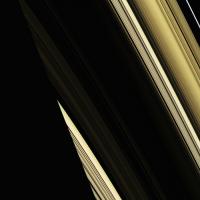
I just love abstract images like this....
I won't claim that these are anywhere close to true color. Full res of this image on flickr here: http://www.flickr.com/photos/31678681@N07/4246131869/ Another in this sequence here: http://www.flickr.com/photos/31678681@N07/...57622089931268/ Two frame composite: http://www.flickr.com/photos/31678681@N07/4246158737/ -------------------- Some higher resolution images available at my photostream: http://www.flickr.com/photos/31678681@N07/
|
|
|
|
|
|
|
Jan 8 2010, 04:05 PM
Post
#34
|
|
|
Junior Member Group: Members Posts: 76 Joined: 19-October 05 Member No.: 532 |
and we get a repeat performance on Jan 27th, the phase is a lot higher (80-125 deg) while the range is ~ 33-38,000 km.
|
|
|
|
|
Jan 8 2010, 05:09 PM
Post
#35
|
|
 Administrator Group: Admin Posts: 5172 Joined: 4-August 05 From: Pasadena, CA, USA, Earth Member No.: 454 |
Sweet! Aren't there a passel of other moons being imaged on the 27th? JPL's space calendar has "Jan 27 - Cassini, Distant Flyby of Telesto, Methone, Pan, Prometheus, Aegaon & Dione"
-------------------- My website - My Patreon - @elakdawalla on Twitter - Please support unmannedspaceflight.com by donating here.
|
|
|
|
|
Jan 9 2010, 01:25 PM
Post
#36
|
|
 Member Group: Members Posts: 655 Joined: 22-January 06 Member No.: 655 |
Going by information elsewhere on the forum, Cassini passes the following moons at reasonably close distances on 27th January. I have no information as to whether the moons are in eclipse at closest approach, whether imaging is planned, or whether other science activities/downlinks take preference at the time. Pixel values assume imaging bang-on closest approach. I would imagine Dione and Prometheus will be imaged, but smaller 'rocks' probably doubtful.
Pan: 95,233km - 54 pixels in the NAC at closest approach Prometheus - 30,492km - 546 pixels Aegaeon - 13,305km - 6 pixels Methone - 74,527km - 7 pixels Telesto - 95,643 - 42 pixels Dione - 46,805km - more than 1 NAC frame Jase |
|
|
|
|
Jan 9 2010, 03:01 PM
Post
#37
|
|
 Senior Member Group: Members Posts: 3648 Joined: 1-October 05 From: Croatia Member No.: 523 |
QUOTE (jasedm @ Jan 9 2010, 02:25 PM)  Pan: 95,233km - 54 pixels in the NAC at closest approach Aegaeon - 13,305km - 6 pixels These two sound like particularly nice opportunities. -------------------- |
|
|
|
|
Jan 10 2010, 08:42 PM
Post
#38
|
|
 Member Group: Members Posts: 226 Joined: 13-October 09 From: Olympus Mons Member No.: 4972 |
Anyone wanna improve the Voyager map Phil made with these Cassini images.
And Prometheus has a seemingly smoother surface than its twin Pandora maybe its because of its larger size causing it to interact more with the F ring. being on the surface of Prometheus is probably like being in a hailstorm. -------------------- "Thats no moon... IT'S A TRAP!"
|
|
|
|
|
Jan 11 2010, 01:45 AM
Post
#39
|
|
|
Member Group: Members Posts: 910 Joined: 4-September 06 From: Boston Member No.: 1102 |
Antdoghalo--Improving on Phil's maps is not a trivial challenge. While many here at UMSF have excellent image manipulation skills, the number with Phil's map making skill is vanishingly small. I would encourage you to work on your own challenge. Maybe after hundreds of hours of map making and manipulation, you can develop into a top flight map maker yourself.
-------------------- |
|
|
|
|
Jan 11 2010, 01:52 AM
Post
#40
|
|
|
Solar System Cartographer Group: Members Posts: 10153 Joined: 5-April 05 From: Canada Member No.: 227 |
Well, thanks! But the biggest obstacle is the lack of a proper 3D shape model. With this new data set and the new one in a few weeks, and any others Cassini might provide, we can hope to create a really good shape model in a few years. It would still be possible to play around with some sketch maps even now, though I'm too busy to do much with it.
Phil -------------------- ... because the Solar System ain't gonna map itself.
Also to be found posting similar content on https://mastodon.social/@PhilStooke Maps for download (free PD: https://upload.wikimedia.org/wikipedia/comm...Cartography.pdf NOTE: everything created by me which I post on UMSF is considered to be in the public domain (NOT CC, public domain) |
|
|
|
|
Jan 13 2010, 06:48 PM
Post
#41
|
|
|
Junior Member Group: Members Posts: 76 Joined: 19-October 05 Member No.: 532 |
QUOTE (jasedm @ Jan 9 2010, 01:25 PM) Going by information elsewhere on the forum, Cassini passes the following moons at reasonably close distances on 27th January. I have no information as to whether the moons are in eclipse at closest approach, whether imaging is planned, or whether other science activities/downlinks take preference at the time. Pixel values assume imaging bang-on closest approach. I would imagine Dione and Prometheus will be imaged, but smaller 'rocks' probably doubtful. Pan: 95,233km - 54 pixels in the NAC at closest approach Prometheus - 30,492km - 546 pixels Aegaeon - 13,305km - 6 pixels Methone - 74,527km - 7 pixels Telesto - 95,643 - 42 pixels Dione - 46,805km - more than 1 NAC frame Jase The moons that will be imaged on Jan 27th are Prometheus and Aegaeon, as part of a single combined Prometheus-Aegaeon- G ring arc observation, and then two separate Dione obs later on in the day. |
|
|
|
|
Jan 13 2010, 08:04 PM
Post
#42
|
|
 Senior Member Group: Moderator Posts: 3233 Joined: 11-February 04 From: Tucson, AZ Member No.: 23 |
QUOTE (pat @ Jan 13 2010, 11:48 AM) The moons that will be imaged on Jan 27th are Prometheus and Aegaeon, as part of a single combined Prometheus-Aegaeon- G ring arc observation, and then two separate Dione obs later on in the day. Actually there is a dedicated Aegaeon observation before that one, during the ring plane crossing (it's just named funny). -------------------- &@^^!% Jim! I'm a geologist, not a physicist!
The Gish Bar Times - A Blog all about Jupiter's Moon Io |
|
|
|
|
Jan 13 2010, 10:06 PM
Post
#43
|
|
|
Member Group: Members Posts: 655 Joined: 22-January 06 Member No.: 655 |
Oooh! Lots of goodies coming up!! Thanks Pat and VP.
January 27th will be an interesting periapse. Any Aegaeon obs. will be too distant relative to the tiny moon to reveal any surface details, but we should get an idea of its shape. The Prometheus pictures should provide coverage which matches the best Pandora data, and the Dione encounter leads in from the moon's nightside- perhaps an opportunity to detect some minimal outgassing if present??? And if that wasn't spoiling us enough, we get a targeted encounter with Mimas on the following revolution approaching to less than 10,000km - a flyby where we finally get to have a good close look at Herschel.... Great times!! |
|
|
|
|
Jan 28 2010, 01:11 PM
Post
#44
|
|
|
Senior Member Group: Members Posts: 3648 Joined: 1-October 05 From: Croatia Member No.: 523 |
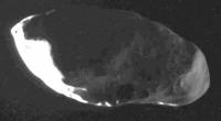
Wow:
http://saturn.jpl.nasa.gov/photos/raw/rawi...?imageID=211928 http://saturn.jpl.nasa.gov/photos/raw/rawi...?imageID=211933 http://saturn.jpl.nasa.gov/photos/raw/rawi...?imageID=211937 Is that F-ring's shadow draping across it? -------------------- |
|
|
|
|
Jan 28 2010, 02:50 PM
Post
#45
|
|||
|
Solar System Cartographer Group: Members Posts: 10153 Joined: 5-April 05 From: Canada Member No.: 227 |
Here's a hint of what's hiding in the shadows...
Phil
-------------------- ... because the Solar System ain't gonna map itself.
Also to be found posting similar content on https://mastodon.social/@PhilStooke Maps for download (free PD: https://upload.wikimedia.org/wikipedia/comm...Cartography.pdf NOTE: everything created by me which I post on UMSF is considered to be in the public domain (NOT CC, public domain) |
||
|
|
|
||
|

|
Lo-Fi Version | Time is now: 27th April 2024 - 04:47 PM |
|
RULES AND GUIDELINES Please read the Forum Rules and Guidelines before posting. IMAGE COPYRIGHT |
OPINIONS AND MODERATION Opinions expressed on UnmannedSpaceflight.com are those of the individual posters and do not necessarily reflect the opinions of UnmannedSpaceflight.com or The Planetary Society. The all-volunteer UnmannedSpaceflight.com moderation team is wholly independent of The Planetary Society. The Planetary Society has no influence over decisions made by the UnmannedSpaceflight.com moderators. |
SUPPORT THE FORUM Unmannedspaceflight.com is funded by the Planetary Society. Please consider supporting our work and many other projects by donating to the Society or becoming a member. |
|