Opportunity Route Map |

  |
Opportunity Route Map |
 Jan 24 2010, 08:31 PM Jan 24 2010, 08:31 PM
Post
#2656
|
|
|
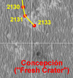
Senior Member  Group: Moderator Posts: 4279 Joined: 19-April 05 From: .br at .es Member No.: 253 |
|
 |
 
|
|
Jan 27 2010, 10:02 AM
Post
#2657
|
||
|
Senior Member Group: Moderator Posts: 4279 Joined: 19-April 05 From: .br at .es Member No.: 253 |
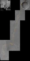
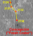
Yet another update; sol 2136. And this time I'm posting the whole map again.
 Route_Map_Sol2136.kml ( 39.4K )
Number of downloads: 621
Route_Map_Sol2136.kml ( 39.4K )
Number of downloads: 621 |
|
|
|
|
|
|
Jan 27 2010, 12:50 PM
Post
#2658
|
|
 Junior Member Group: Members Posts: 73 Joined: 10-May 06 From: Spain Member No.: 770 |
Hi,
I have long followed this thread but I have not written much already, really. I have a question about the maps published in KML format. Indeed, an extraordinary job. Take this opportunity to congratulate everyone, especially Teehseiner. The doubt is that when you load the KML in Google Earth does not get a high resolution map of the latter sites the Rover. Specifically since the route began in Sol 2042. How can I get it to load in the background?. Thanks |
|
|
|
|
Jan 27 2010, 01:35 PM
Post
#2659
|
|
 Senior Member Group: Moderator Posts: 2262 Joined: 9-February 04 From: Melbourne - Oz Member No.: 16 |
-------------------- |
|
|
|
|
Jan 27 2010, 01:36 PM
Post
#2660
|
|
|
Senior Member Group: Moderator Posts: 4279 Joined: 19-April 05 From: .br at .es Member No.: 253 |
This section of the background is not part of GE itself but another KML layer created by UMSF member SFJCody based on HiRISE maps.
You should download it with uTorrent. The link is, ..., mmm, somewhere here in this very same thread (edit: already answered by James). |
|
|
|
|
Jan 29 2010, 09:37 AM
Post
#2661
|
|
|
Junior Member Group: Members Posts: 73 Joined: 10-May 06 From: Spain Member No.: 770 |
QUOTE (Tesheiner @ Jan 27 2010, 02:36 PM)  This section of the background is not part of GE itself but another KML layer created by UMSF member SFJCody based on HiRISE maps. You should download it with uTorrent. The link is, ..., mmm, somewhere here in this very same thread (edit: already answered by James). Thank you both. Everything perfect now. |
|
|
|
|
Jan 29 2010, 10:31 AM
Post
#2662
|
|
|
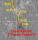
Senior Member Group: Moderator Posts: 4279 Joined: 19-April 05 From: .br at .es Member No.: 253 |
|
|
|
|
|
Jan 29 2010, 07:48 PM
Post
#2663
|
|
 Member Group: Members Posts: 404 Joined: 5-January 10 Member No.: 5161 |
I can't believe found this forum only recently, after following Oppy's progress on JPL's website for the last 5 years, where maps are updated every few months. Very cool to see these maps updated in real time here! Thank you.
|
|
|
|
|
Jan 29 2010, 10:08 PM
Post
#2664
|
|
|
Senior Member Group: Members Posts: 3516 Joined: 4-November 05 From: North Wales Member No.: 542 |
Welcome on board!
|
|
|
|
|
Jan 30 2010, 09:06 AM
Post
#2665
|
|
|
Senior Member Group: Members Posts: 3516 Joined: 4-November 05 From: North Wales Member No.: 542 |
If admins approve, and to celebrate the opening up of wide horizons, I suggest a new thread called 'distant vistas' or something like that to hold discussions of this kind. We don't want to clutter up this thread or other location-specific ones. With that in mind here are a couple of links to start off:
QUOTE (fredk @ Jan 28 2010, 04:35 PM) [attachment=20492:Eagle_En...evations.gif] http://www.unmannedspaceflight.com/index.p...amp;qpid=154408 http://www.unmannedspaceflight.com/index.p...amp;qpid=141505 In passing I note that the nearest Endeavour 'rim' hills actually rise from some way down inside the hole so we won't see their feet till we're almost there. In the Endeavour Crater thread there was a very nice HRSC 3D view of Endeavour which somebody annotated with elevations. I wanted to look at that again but the HRSC links no longer work for me. Can anybody help with that? |
|
|
|
|
Jan 30 2010, 09:34 AM
Post
#2666
|
|
|
Senior Member Group: Moderator Posts: 4279 Joined: 19-April 05 From: .br at .es Member No.: 253 |
You are right, and I was wondering the same yesterday.
New thread Distant vistas: Endeavour, Iazu and beyond created. |
|
|
|
|
Feb 3 2010, 09:03 AM
Post
#2667
|
|
|
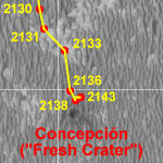
Senior Member Group: Moderator Posts: 4279 Joined: 19-April 05 From: .br at .es Member No.: 253 |
|
|
|
|
|
Feb 4 2010, 12:36 AM
Post
#2668
|
|
|
Member Group: Members Posts: 404 Joined: 5-January 10 Member No.: 5161 |
QUOTE (Tesheiner @ Feb 3 2010, 01:03 AM) Map update after sol 2143. Tesheiner, your maps look just like the official ones on JPL's website. Are you the real thing? If so, that is awesome that you post them here for us, and so up-to-date. As I've said in a previous post, I can't believe I just found this forum. It's a privilege to be following this historic expedition, and to read posts from "insiders," if that's the case. Thanks again. |
|
|
|
|
Feb 4 2010, 09:28 AM
Post
#2669
|
|
|
Senior Member Group: Moderator Posts: 4279 Joined: 19-April 05 From: .br at .es Member No.: 253 |
QUOTE (walfy @ Feb 4 2010, 01:36 AM) Tesheiner, your maps look just like the official ones on JPL's website. Huh?  Sorry, but I don't see the coincidence. And no, I'm just a "space enthusiast", no "insider". |
|
|
|
|
Feb 4 2010, 11:14 AM
Post
#2670
|
|
|
Founder Group: Chairman Posts: 14432 Joined: 8-February 04 Member No.: 1 |
QUOTE (walfy @ Feb 4 2010, 12:36 AM) Tesheiner, your maps look just like the official ones on JPL's website. I think this says a lot about ET's talent. But at some level, when you're drawing points ( which you know to be right ) on the same reference image, two maps are going to look pretty much alike. ETs map's were not always as awesome as this....but they have always been awesome  |
|
|
|
|

|
Lo-Fi Version | Time is now: 28th April 2024 - 12:22 PM |
|
RULES AND GUIDELINES Please read the Forum Rules and Guidelines before posting. IMAGE COPYRIGHT |
OPINIONS AND MODERATION Opinions expressed on UnmannedSpaceflight.com are those of the individual posters and do not necessarily reflect the opinions of UnmannedSpaceflight.com or The Planetary Society. The all-volunteer UnmannedSpaceflight.com moderation team is wholly independent of The Planetary Society. The Planetary Society has no influence over decisions made by the UnmannedSpaceflight.com moderators. |
SUPPORT THE FORUM Unmannedspaceflight.com is funded by the Planetary Society. Please consider supporting our work and many other projects by donating to the Society or becoming a member. |
|