Opportunity Route Map |

  |
Opportunity Route Map |
 Apr 1 2005, 05:11 PM Apr 1 2005, 05:11 PM
Post
#316
|
|
|
Member  Group: Members Posts: 111 Joined: 14-March 05 From: Vastitas Borealis Member No.: 193 |
It does interest me indeed. (Some thinkers think it quite wisely, 'don't look back'. But that's not so wise a seafaring principle.)
-The link below gives the looks of the backshell & parachute from Eagle, 440 m away. (Of course a combination of filters.) I would be absolutely astonished if we could not see a trace of them on that flatness anymore now, from only six times that distance, ~2600 m. (If advice is needed: think it one sixth of that size, even in medium res.) http://www.jpl.nasa.gov/missions/mer/images.cfm?id=1235 For my part, I see this case settled as for the facts, and we can turn forwards again, for a while. |
 |
 
|
|
Apr 1 2005, 06:46 PM
Post
#317
|
|
|
Founder Group: Chairman Posts: 14432 Joined: 8-February 04 Member No.: 1 |
We cant see the heatshield anymore - why should we be able to see the backshell?
Doug |
|
|
|
|
Apr 1 2005, 09:02 PM
Post
#318
|
|
 Senior Member Group: Members Posts: 1281 Joined: 18-December 04 From: San Diego, CA Member No.: 124 |
QUOTE (marswiggle @ Mar 30 2005, 09:17 PM) Is it possible that Oppy has detected its backshell and parachute in the distance? These are from the latest posting of pancam images. The direction is about right, NNW. A dark dot beside a whitish one near the horizon, and they are similar both in L and R images. They sit neatly into the scenery when looked in 3d. http://qt.exploratorium.edu/mars/opportuni...00P2291L1M1.JPG http://qt.exploratorium.edu/mars/opportuni...00P2291R2M1.JPG  Well, the parallax looks way off to me for something that's supposed to be 2.5 kilometers away.... -------------------- Lyford Rome
"Zis is not nuts, zis is super-nuts!" Mathematician Richard Courant on viewing an Orion test |
|
|
|
|
Apr 1 2005, 10:49 PM
Post
#319
|
|
|
Founder Group: Chairman Posts: 14432 Joined: 8-February 04 Member No.: 1 |
It isnt the backshell. It's the wrong colour, the wrong size, and the wrong distance.
Doug |
|
|
|
|
Apr 1 2005, 11:30 PM
Post
#320
|
|
 Senior Member Group: Members Posts: 1887 Joined: 20-November 04 From: Iowa Member No.: 110 |
QUOTE (djellison @ Apr 1 2005, 06:46 PM) We cant see the heatshield anymore - why should we be able to see the backshell? Doug The image is from sol 409. http://marsrovers.jpl.nasa.gov/gallery/all...00P2291R2M1.JPG The heatshield was still visible then http://marsrovers.jpl.nasa.gov/gallery/all...00P2291R2M1.JPG |
|
|
|
|
Apr 1 2005, 11:45 PM
Post
#321
|
|
|
Member Group: Members Posts: 111 Joined: 14-March 05 From: Vastitas Borealis Member No.: 193 |
Well, kind od edit - I meant the case is 'settled' for the facts part, i.e. all the facts presented in the forum. Anyone can form an opinion. The truth about the dot's nature inevitably stays unsettled based on that knowledge. I don't know. Only made the observation and presented some facts in my reach. Can't still see it otherwise - perhaps someday with more wisdom?
EDIT after Alan's post - Thanks for that pancam image with *shiny* heatshield and Endurance. I couldn't find it, and therefore I was myself getting unsure. I originally estimated the angle from End to backshell based on a guess of End's location. My guess was just right. The angle should be a little less than 2 pancam frames wide, or somewhere between 20 and 25 degrees west from End. As measured from a map showing Oppy's location around sol 410 (as I thought), the angle between End and backshell is about 22 degrees. (This only as a reference to facts, not to the truth.  ) )
|
|
|
|
|
Apr 2 2005, 02:39 AM
Post
#322
|
|
|
Member Group: Members Posts: 111 Joined: 14-March 05 From: Vastitas Borealis Member No.: 193 |
Some corrections to what I mentioned above:
My original angle estimate was from N (not End) to backshell. The images being sol 409, a new measuring reduces the then distance to bs to somewhere btw 2100-2200m, (ie only 5x that from Eagle), and the map-measured angle fits yet better to that from pancam frames. The parallax should also be more convincing now. These inaccuracies may have added to some confusion. |
|
|
|
|
Apr 4 2005, 10:38 PM
Post
#323
|
|
|
Junior Member Group: Members Posts: 45 Joined: 25-March 05 Member No.: 216 |
Does anyone know when Oppy will reach Erebus? How long will it take to reach Erebus from Voyager?
Does the etched terrain start before Erebus? -------------------- My Open Office Website: http://www.openofficetips.com
|
|
|
|
|
Apr 5 2005, 12:15 AM
Post
#324
|
||
 The Insider Group: Members Posts: 669 Joined: 3-May 04 Member No.: 73 |
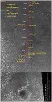
Updated Opportunity Route Map:
Attached thumbnail(s)
|
|
|
|
|
|
|
Apr 5 2005, 07:35 AM
Post
#325
|
|
 Senior Member Group: Members Posts: 3419 Joined: 9-February 04 From: Minneapolis, MN, USA Member No.: 15 |
QUOTE (avkillick @ Apr 4 2005, 04:38 PM) Does anyone know when Oppy will reach Erebus? How long will it take to reach Erebus from Voyager? Does the etched terrain start before Erebus? There are a couple of different landforms, here. There is what I think of as the true etched terrain, which has ridges of what look like evaporite outcrop surrounded by duneform-controlled patterns of dark and light sand. What lies directly between Oppy right now and its target at Erebus doesn't seem to have any actual outcrop (at least not any more than you would see out on the flat plains) -- it's just got what looks like duneforms of lighter sand overlying the dark, concretion-derived sand layer. As we get closer to Erebus and the ancient crater cluster to its south, some of the duning looks a *lot* lighter. It's going to be very interesting to take a close look at the lighter sand in those dunes as we head south to Erebus. I would have to think there will be some significant differences in minerology between this lighter sand and the soils we've seen thus far. -the other Doug -------------------- The trouble ain't that there is too many fools, but that the lightning ain't distributed right. -Mark Twain
|
|
|
|
|
Apr 5 2005, 05:45 PM
Post
#326
|
|
|
Member Group: Members Posts: 109 Joined: 9-April 04 Member No.: 66 |
What's happening now? Are we on the move towards Erebus?
|
|
|
|
| Guest_Sunspot_* |
Apr 5 2005, 05:53 PM
Post
#327
|
|
Guests |
Judging from the latest hazcam image, it looks like they might be positioning the rover for some IDD work.
......also, looking at Pando's updated route map, Opportunity must be very close to the 5km mark now. |
|
|
|
|
Apr 5 2005, 08:10 PM
Post
#328
|
||
|
Solar System Cartographer Group: Members Posts: 10153 Joined: 5-April 05 From: Canada Member No.: 227 |
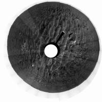
There has been a lot of dispute about where Opportunity is, though to me it's clear it is beside Voyager crater. However, I thought this approach might help to clear things up. You can take a 360 pan in Photoshop and use Filter-Distort-Polar Coordinates to make a 'donut' presentation of it. I have one here from sol 418 near "mini Fram". The pan was from an earlier post, I forgot to record which, I'm sorry.
Polar coordinates takes a bit of getting used to. The image must be square, so the long pan is made square with 'image size' . Top goes to the center so it has to be rotated 180 degrees. To get a more map-like perspective I also stretch it by at least a factor of ten vertically, then progressively shrink the foreground in a series of transform-scale operations. Complicated, but excellent results. If you look at this you can see Viking and Voyager as low rock piles at the expected azimuths near the bottom. Everything lies at the expected azimuth, which is why this is really useful for localization. Search for my name on the Lunar Photo of the Day to see an Apollo 14 pan done this way! Phil
|
|
|
|
|
|
|
Apr 5 2005, 10:52 PM
Post
#329
|
|
|
Solar System Cartographer Group: Members Posts: 10153 Joined: 5-April 05 From: Canada Member No.: 227 |
Just adding to my reprojected pan post... that image matches in every detail the map posted by Pando at:
http://www.unmannedspaceflight.com/index.p...ype=post&id=431 but it does NOT match the other interpretation which suggests that 'Mini Fram ' was the location on sol 421, and that today Opportunity is at Viking. Phil -------------------- ... because the Solar System ain't gonna map itself.
Also to be found posting similar content on https://mastodon.social/@PhilStooke Maps for download (free PD: https://upload.wikimedia.org/wikipedia/comm...Cartography.pdf NOTE: everything created by me which I post on UMSF is considered to be in the public domain (NOT CC, public domain) |
|
|
|
|
Apr 6 2005, 01:41 AM
Post
#330
|
|
|
The Insider Group: Members Posts: 669 Joined: 3-May 04 Member No.: 73 |
Awesome projection, Phil. Thank you. Can you do the same projection for the navcam images next to Viking as well?
http://qt.exploratorium.edu/mars/opportuni...cam/2005-03-31/ Looks like we're ready to spring south toward a small crater named.... uh... (think Gilligans  ) )http://qt.exploratorium.edu/mars/opportuni...GYP1214L0M1.JPG |
|
|
|
|

|
Lo-Fi Version | Time is now: 29th April 2024 - 10:12 PM |
|
RULES AND GUIDELINES Please read the Forum Rules and Guidelines before posting. IMAGE COPYRIGHT |
OPINIONS AND MODERATION Opinions expressed on UnmannedSpaceflight.com are those of the individual posters and do not necessarily reflect the opinions of UnmannedSpaceflight.com or The Planetary Society. The all-volunteer UnmannedSpaceflight.com moderation team is wholly independent of The Planetary Society. The Planetary Society has no influence over decisions made by the UnmannedSpaceflight.com moderators. |
SUPPORT THE FORUM Unmannedspaceflight.com is funded by the Planetary Society. Please consider supporting our work and many other projects by donating to the Society or becoming a member. |
|