Journey to Mt Sharp - Part 1: Site 7 to Waypoint 1, Sol324 [Jul4,'13] to Sol391 [Sep12,'13] |

  |
Journey to Mt Sharp - Part 1: Site 7 to Waypoint 1, Sol324 [Jul4,'13] to Sol391 [Sep12,'13] |
 Aug 13 2013, 04:45 PM Aug 13 2013, 04:45 PM
Post
#301
|
|
|
Senior Member  Group: Members Posts: 2346 Joined: 7-December 12 Member No.: 6780 |
QUOTE (RoverDriver @ Aug 13 2013, 04:51 PM)  For example Sol 102 and 159 were T&G, I think? I also thought, there have been "touch and go"s before. Ken Herkenhoff, at least, had been announcing one for Sol 360: Sol 360: Update On Curiosity From USGS Scientist Ken Herkenhoff: Touch and Go QUOTE My SOWG Chair shift today was especially busy, as we planned MSL's first "touch and go...
|
 |
 
|
|
Aug 13 2013, 06:15 PM
Post
#302
|
|
|
Founder Group: Chairman Posts: 14432 Joined: 8-February 04 Member No.: 1 |
QUOTE (marsophile @ Aug 13 2013, 08:21 AM) Is nighttime driving for Curiosity totally not feasible Not technically impossible - but utterly impractical. 1) Need the Hazcam's to see the terrain to assess it for hazards as the drive is occurring. At night - it's dark. 2) It's cold - therefore a LOT of heating for the motors etc if you're trying to drive at night. 3) State of charge - the rover sleeps, generally, overnight, to recharge the battery. Driving would result in waking up with a low state of charge, thus leaving the rover to recharge during the next day. Moreover - why would you want to? The number of daylight hours is not a constraint on driving. MRO orbital mechanics (for timing of when to stop for UHF pass at end of drive) and power/data budgets are. |
|
|
|
|
Aug 14 2013, 01:38 AM
Post
#303
|
|
 Administrator Group: Admin Posts: 5172 Joined: 4-August 05 From: Pasadena, CA, USA, Earth Member No.: 454 |
QUOTE (RoverDriver @ Aug 13 2013, 06:51 AM) For example Sol 102 and 159 were T&G, I think? Oops, my bad! I must have been thinking of something else. Post edited.-------------------- My website - My Patreon - @elakdawalla on Twitter - Please support unmannedspaceflight.com by donating here.
|
|
|
|
|
Aug 14 2013, 01:55 AM
Post
#304
|
|
 Member Group: Members Posts: 222 Joined: 7-August 12 From: Garberville, CA Member No.: 6500 |
GOING DEEP on Mt. Sharp...
Long drives and big panoramas equal nice wide stereo baselines. Here's a 16,220 x 1,250 pixel anaglyph of Mt. Sharp, with the Sol 344 MC 34 pano (left channel) and the Sol352 MC 34 pano (right channel) providing a surprisingly deep 3D look at the mountain and its approaches. The basline separation is about 260 meters; enough offset to actually make out a number of features on the upper slopes of Mt. Sharp in reasonably good stereo. The near foregrounds of course do not match in the least. Both the default and a slightly level enhanced (for a bit better detail in washed out areas but slightly darker overall) versions are below. For the first time I noticed several features on the slopes of Mt. Sharp I hadn't seen before or viewed with any kind of reasonable clarity, in stereo anyway. About half way up the slope, a bit right of center, where the tilted layers of the formation that dominates of the entire right side of the mountain peter out onto the central slope there appear to be two large flat "terraces" with rounded edges. They almost look like the remants of a massive landslide that left two large folds on the slope. There are some large "pinnacles" scattered about the slope to the left of these terraces, and at the upper left, just below the summit, a prominant row of massive cliffs (that almost appear to have layered strata) can be nicely seen too. Of special interest are the various mesas, buttes, and broken terrain scattered about the dune field toward our direction of travel at the right side of the image. The Sol 344 pano wasn't completely imaged on the right side (dang it) but I left the right channel counterpart visible for reference. Default:  Detail Enhanced:  Edit: Looks as if those terraces I mentioned are the two most northerly elements of the large tilted "light-toned yardangs" (from Anderson & Bell) formation. From our vantage point we see mostly the western half (East-West trending) of these. These two on the other hand appear to be the upper most elements of the other side (NE-SW trending) of the formation: 
-------------------- "We shall not cease from exploration, and the end of all our exploring will be to arrive where we started and know the place for the first time." -T.S. Eliot
|
|
|
|
|
Aug 14 2013, 10:51 AM
Post
#305
|
|
|
Senior Member Group: Members Posts: 2346 Joined: 7-December 12 Member No.: 6780 |
Sol 361 ML autostitch, with some (imperfect) exposure adjustment, white-balancing, saturation enhancement, sharpening:

|
|
|
|
|
Aug 14 2013, 12:57 PM
Post
#306
|
|
 Member Group: Members Posts: 161 Joined: 12-August 12 From: Hillsborough, NJ Member No.: 6546 |
My take on 361:
 Full size: http://www.flickr.com/photos/84750994@N05/...710620/sizes/o/ Ed: Brilliant. Awesome. 
-------------------- |
|
|
|
|
Aug 14 2013, 03:59 PM
Post
#307
|
||
|
Solar System Cartographer Group: Members Posts: 10153 Joined: 5-April 05 From: Canada Member No.: 227 |
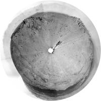
post-drive location on sol 363, a rough circular view of it. Cute little craters to the north. EDIT - replaced with a full pan after the last images came down. The route map needs adjustment - the drive had a kink in it. Next map post will include that change.
Phil
-------------------- ... because the Solar System ain't gonna map itself.
Also to be found posting similar content on https://mastodon.social/@PhilStooke Maps for download (free PD: https://upload.wikimedia.org/wikipedia/comm...Cartography.pdf NOTE: everything created by me which I post on UMSF is considered to be in the public domain (NOT CC, public domain) |
|
|
|
|
|
|
Aug 14 2013, 04:43 PM
Post
#308
|
|
|
Senior Member Group: Members Posts: 2346 Joined: 7-December 12 Member No.: 6780 |
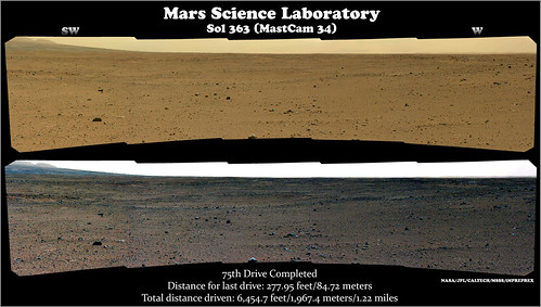
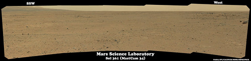
Sol 363 post-drive Navcam x-eyeds, looking south-west
 and north and north  . .Edit: Anaglyph version of the north-looking stereo: 
|
|
|
|
|
Aug 14 2013, 11:51 PM
Post
#309
|
|
|
Senior Member Group: Members Posts: 2346 Joined: 7-December 12 Member No.: 6780 |
Sol 362 MARDI, some dust-decoating:
 Sol 363 post-drive MAHLI, rotated 150 degrees and white-balanced with lower sky as reference:  . .EdTruthan, identifying the individual yardangs, visible in the Mastcam images, with the HiRISE correspondings is challenging a bit, at least for me.
|
|
|
|
|
Aug 15 2013, 11:08 AM
Post
#310
|
|
|
Member Group: Members Posts: 153 Joined: 4-May 11 From: Pardubice, CZ Member No.: 5979 |
QUOTE (Phil Stooke @ Aug 13 2013, 03:45 PM) "Restricted Sols" has a very specific meaning... Phil, thanks a lot for the explanation |
|
|
|
|
Aug 15 2013, 01:33 PM
Post
#311
|
|
 Member Group: Members Posts: 219 Joined: 14-November 11 From: Washington, DC Member No.: 6237 |
There is also a good discussion by Matt Lenda of Nominal/Restricted/Slide/Tight planning modes here:
http://opportunityendeavour.blogspot.com/2...-terms-and.html I learned a ton from his blog series. Despite the number of good sources we have, I look forward to the day when someone can give us that level of insight into MSL ops. |
|
|
|
|
Aug 15 2013, 02:45 PM
Post
#312
|
|
|
Senior Member Group: Members Posts: 2346 Joined: 7-December 12 Member No.: 6780 |
A lot of detailed information is available via Analyst's Notebook.
"SOWG Documentarian uplink report | Sol 00179" as one example:  00179_0049.htm ( 20.46K )
Number of downloads: 523
00179_0049.htm ( 20.46K )
Number of downloads: 523Those reports can be obtained the following way: Open AN's sol tab, expand a sol branch in the navigation tree, e.g. "Sol 179", expand the "Sol 179 documents (2)" branch, expand "SOWG Documentarian - Uplink (1)", select "SOWG Documentarian uplink report (21 KB)". Via menu bar item (right panel) "Actions/Download" you'll get a copy of the file, like the attachment above. So, very recent activities aren't available, but much detail with a certain delay. Reading several subsequent sol reports will give a better general understanding of how decisions are made, and which constraints have to be considered. |
|
|
|
|
Aug 15 2013, 05:30 PM
Post
#313
|
|
|
Member Group: Members Posts: 222 Joined: 7-August 12 From: Garberville, CA Member No.: 6500 |
Sol 363 - Navcam 360 Anaglyph...

-------------------- "We shall not cease from exploration, and the end of all our exploring will be to arrive where we started and know the place for the first time." -T.S. Eliot
|
|
|
|
|
Aug 15 2013, 05:31 PM
Post
#314
|
|
|
Member Group: Members Posts: 161 Joined: 12-August 12 From: Hillsborough, NJ Member No.: 6546 |
-------------------- |
|
|
|
|
Aug 15 2013, 09:23 PM
Post
#315
|
|
|
Solar System Cartographer Group: Members Posts: 10153 Joined: 5-April 05 From: Canada Member No.: 227 |
"Matt Heverly @Matt_Heverly 14 Aug
We are more than half way to our first geologically waypoint as we drive to Mt. Sharp." What a tease! Phil -------------------- ... because the Solar System ain't gonna map itself.
Also to be found posting similar content on https://mastodon.social/@PhilStooke Maps for download (free PD: https://upload.wikimedia.org/wikipedia/comm...Cartography.pdf NOTE: everything created by me which I post on UMSF is considered to be in the public domain (NOT CC, public domain) |
|
|
|
|

|
Lo-Fi Version | Time is now: 29th April 2024 - 09:53 PM |
|
RULES AND GUIDELINES Please read the Forum Rules and Guidelines before posting. IMAGE COPYRIGHT |
OPINIONS AND MODERATION Opinions expressed on UnmannedSpaceflight.com are those of the individual posters and do not necessarily reflect the opinions of UnmannedSpaceflight.com or The Planetary Society. The all-volunteer UnmannedSpaceflight.com moderation team is wholly independent of The Planetary Society. The Planetary Society has no influence over decisions made by the UnmannedSpaceflight.com moderators. |
SUPPORT THE FORUM Unmannedspaceflight.com is funded by the Planetary Society. Please consider supporting our work and many other projects by donating to the Society or becoming a member. |
|