Solander Point, Sol 3387 - 3511 (August 4, 2013 - December 12, 2013) |

  |
Solander Point, Sol 3387 - 3511 (August 4, 2013 - December 12, 2013) |
 Sep 5 2013, 06:27 AM Sep 5 2013, 06:27 AM
Post
#61
|
|
 Senior Member  Group: Members Posts: 2492 Joined: 15-January 05 From: center Italy Member No.: 150 |
I guess Oppy wasn't in autonomous navigation mode, but I wonder there wasn't any sort of proximity alarm and automatic safe stop for such situations, eventually triggered by hazardcams!
-------------------- I always think before posting! - Marco -
|
 |
 
|
|
Sep 5 2013, 12:43 PM
Post
#62
|
|
|
Senior Member Group: Moderator Posts: 4279 Joined: 19-April 05 From: .br at .es Member No.: 253 |
The F/R-Hazcams "per se" can't do that. You need a sort of hazard avoidance SW built on top to do that function. And IIRC autonav includes this feature but it is quite slow.
|
|
|
|
|
Sep 5 2013, 01:16 PM
Post
#63
|
|
|
Senior Member Group: Members Posts: 3516 Joined: 4-November 05 From: North Wales Member No.: 542 |
I'm struggling to understand how colliding with a rock at a speed of a few centimetres per second could have been "mission catastrophic". (Just as well my car is more robust.)
|
|
|
|
|
Sep 5 2013, 01:26 PM
Post
#64
|
|
|
Founder Group: Chairman Posts: 14432 Joined: 8-February 04 Member No.: 1 |
It would probably damage solar panels quite badly. Moreover, you're then hung up on a rock with the arrays - you need to get 'off' that, which will cause more damage.
|
|
|
|
|
Sep 5 2013, 02:02 PM
Post
#65
|
|
|
Solar System Cartographer Group: Members Posts: 10153 Joined: 5-April 05 From: Canada Member No.: 227 |
I would have thought that constant monitoring of tilt and engineering data from wheels etc. would stop the drive before anything got hung up too much. But obviously much better to avoid it than to test my assumptions.
Phil -------------------- ... because the Solar System ain't gonna map itself.
Also to be found posting similar content on https://mastodon.social/@PhilStooke Maps for download (free PD: https://upload.wikimedia.org/wikipedia/comm...Cartography.pdf NOTE: everything created by me which I post on UMSF is considered to be in the public domain (NOT CC, public domain) |
|
|
|
|
Sep 5 2013, 02:57 PM
Post
#66
|
|||
 Senior Member Group: Moderator Posts: 3431 Joined: 11-August 04 From: USA Member No.: 98 |
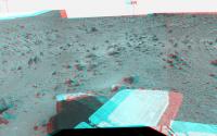
In stereo, it didn't look to me like Mulla Mulla was tall enough to hit the arrays. Unless she tilted more - which could easily have been in the cards I guess.
Wopmay looked scarier 
Attached thumbnail(s)
|
||
|
|
|
||
|
Sep 5 2013, 04:18 PM
Post
#67
|
|
|
Senior Member Group: Moderator Posts: 4279 Joined: 19-April 05 From: .br at .es Member No.: 253 |
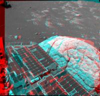
Not tall enough but its size was only known with a given margin when it was seen from the position before that drive was executed. It might not have contacted the wings but damaged the wiring under them.
Regarding tilt and other data monitoring, I think that would not be enough to stop the rover in this kind of scenario. |
|
|
|
|
Sep 6 2013, 10:49 PM
Post
#68
|
|
|
Senior Member Group: Members Posts: 1043 Joined: 17-February 09 Member No.: 4605 |
Referring back to post 51, the PS update confirms that "Coal Island" is the contact between the planar and tilted laminae. But the planar bench ("Grasberg unit") was designated altered material eroded from old Endeavour rim "Shoemaker" material. Is this implying that the tilted laminae represents pre impact sedimentary layering rather than Grasberg unit material tilted due to a local subsidence?
|
|
|
|
|
Sep 6 2013, 11:08 PM
Post
#69
|
|
|
Solar System Cartographer Group: Members Posts: 10153 Joined: 5-April 05 From: Canada Member No.: 227 |
The Grasberg unit is the lowest layer of the Burns Formation, the stack of sulfate-rich sandstones seen all over Meridiani. They sit on top of the layer of debris eroded off the Endeavour rim hills. The scarp here, the little step up above the bench, is presumably that eroded debris. The exact relationship is not easy to figure out just looking at the images here, but it seemed to be clearer at the north end of Cape York.
More interesting to me is the origin of the basalt boulders like Tick Bush. Are they ejecta thrown in from a distant impact? I don't see any sign of basalt flows in the vicinity. Phil -------------------- ... because the Solar System ain't gonna map itself.
Also to be found posting similar content on https://mastodon.social/@PhilStooke Maps for download (free PD: https://upload.wikimedia.org/wikipedia/comm...Cartography.pdf NOTE: everything created by me which I post on UMSF is considered to be in the public domain (NOT CC, public domain) |
|
|
|
|
Sep 7 2013, 11:06 PM
Post
#70
|
||
|
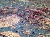
Senior Member Group: Members Posts: 1043 Joined: 17-February 09 Member No.: 4605 |
Not sure that you are correct there Phil. On CY the Burns Formation sulphate sandstone onlaps the bench (Deadwood - Grasberg unit) which is eroded material from Cape York (Shoemaker), and the same seems true here. The basaltic boulders seem to be eroding out of the upturned rim remnant. Given that Endeavour was formed by an impact into hundreds of meter thick Miyamoto ejecta they could well pre-date the impact. Coal Island is a contact between two units with, in false colour, seemingly different lithology and what I find fascinating is the possibility that the tilted laminae could be a pre-impact deposit.
Attached thumbnail(s)
|
|
|
|
|
|
|
Sep 7 2013, 11:37 PM
Post
#71
|
||
 Member Group: Members Posts: 404 Joined: 5-January 10 Member No.: 5161 |
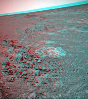
Nice view of the "shore" in 3D, sol 3419:
|
|
|
|
|
|
|
Sep 8 2013, 04:11 AM
Post
#72
|
|
|
Solar System Cartographer Group: Members Posts: 10153 Joined: 5-April 05 From: Canada Member No.: 227 |
Re: the Grasberg unit:
https://gsa.confex.com/gsa/2013AM/webprogra...aper233091.html "The bright outcrop margin (the Grasberg unit) is the most prominent of several successive onlaps of thinly-laminated sulfate sediments onto the crater rim inselbergs." And also: http://www.lpi.usra.edu/meetings/lpsc2013/pdf/2292.pdf "A stop at the site named Grasberg confirmed through MI and APXS analysis that this band is a material distinct from either the materials of Cape York or the Burns Formation. Grasberg is an unusual composition with elevated Cl, and a grain-size finer than the MI resolution, in contrast to the coarse sandstone typical of Meridiani. This is a relatively thin (several tens of cm thick) unit that unconformably overlies the slopes of an eroded Cape York." Phil -------------------- ... because the Solar System ain't gonna map itself.
Also to be found posting similar content on https://mastodon.social/@PhilStooke Maps for download (free PD: https://upload.wikimedia.org/wikipedia/comm...Cartography.pdf NOTE: everything created by me which I post on UMSF is considered to be in the public domain (NOT CC, public domain) |
|
|
|
|
Sep 8 2013, 07:16 AM
Post
#73
|
|
|
Senior Member Group: Members Posts: 1043 Joined: 17-February 09 Member No.: 4605 |
I think the following paper goes a little deeper into explanation of the bench Phil: http://www.lpi.usra.edu/meetings/lpsc2013/pdf/2294.pdf
To quote, A rock unit ringing the base of Cape York was investigated at Deadwood and again at Grasberg, at Cape Yorks northern tip. This unit is bright-toned with platy, millimeter-scale layering. Its elemental composition is intermediate between the rocks of the Shoemaker formation and the Burns Formation, with elevated Ca and S concentrations, interpreted as a clastic sedimentary rock formed by erosion of the Shoemaker Formation and later modified to create the S enrichment. Squires also tributed the bench to shoemaker detritus in his Nature article Ancient Impact and Aqueous Processes at Endeavour Crater, Mars although he differentiated between inner and outer bench material (outer being Burns formation onlap which is quite pronounced to the west of CY). Identifying the bench as eroded rim breccia material seems an important call in defining Endeavour, confirming that the Burns unit was deposited a long time after the impact, when the rim had eroded away. |
|
|
|
|
Sep 9 2013, 10:37 AM
Post
#74
|
|
|
Forum Contributor Group: Members Posts: 1372 Joined: 8-February 04 From: North East Florida, USA. Member No.: 11 |
QUOTE (ngunn @ Sep 5 2013, 01:16 PM)  I'm struggling to understand how colliding with a rock at a speed of a few centimetres per second could have been "mission catastrophic". (Just as well my car is more robust.) Remember Oppy does not travel very fast but she has tons of torque, so she could crunch herself pretty bad. |
|
|
|
|
Sep 9 2013, 09:16 PM
Post
#75
|
|
|
Member Group: Members Posts: 866 Joined: 15-March 05 From: Santa Cruz, CA Member No.: 196 |
One wonders whether Oppy's accelerometers are used in general drive usage for instance to adjust drive behavior over small rocks, which should nullify hazards such as this, since any sensed impasse should signal to adjust suspension, wheel spin, etc. in adaptation to the terrain feature encountered... or maybe they are only used to measure degree of tilt? i'm sure im oversimplifying it and someone here is probably familiar with those specs..
|
|
|
|
|

|
Lo-Fi Version | Time is now: 28th April 2024 - 02:14 AM |
|
RULES AND GUIDELINES Please read the Forum Rules and Guidelines before posting. IMAGE COPYRIGHT |
OPINIONS AND MODERATION Opinions expressed on UnmannedSpaceflight.com are those of the individual posters and do not necessarily reflect the opinions of UnmannedSpaceflight.com or The Planetary Society. The all-volunteer UnmannedSpaceflight.com moderation team is wholly independent of The Planetary Society. The Planetary Society has no influence over decisions made by the UnmannedSpaceflight.com moderators. |
SUPPORT THE FORUM Unmannedspaceflight.com is funded by the Planetary Society. Please consider supporting our work and many other projects by donating to the Society or becoming a member. |
|