Journey to Mt Sharp - Part 5: Into the Valleys, Sol 706-752, Aug 1-Sep 17, 2014 |

  |
Journey to Mt Sharp - Part 5: Into the Valleys, Sol 706-752, Aug 1-Sep 17, 2014 |
 Sep 4 2014, 10:06 AM Sep 4 2014, 10:06 AM
Post
#226
|
|
 Member  Group: Members Posts: 809 Joined: 3-June 04 From: Brittany, France Member No.: 79 |
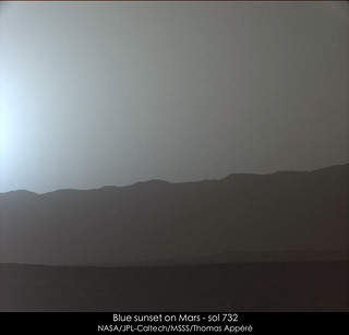
Nice blue sunset on sol 734:
-------------------- |
 |
 
|
|
Sep 4 2014, 04:45 PM
Post
#227
|
||
|
Solar System Cartographer Group: Members Posts: 10153 Joined: 5-April 05 From: Canada Member No.: 227 |
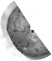
A circular half-pan shows us closer to the edge of the outcrop on sol 739.
Phil
-------------------- ... because the Solar System ain't gonna map itself.
Also to be found posting similar content on https://mastodon.social/@PhilStooke Maps for download (free PD: https://upload.wikimedia.org/wikipedia/comm...Cartography.pdf NOTE: everything created by me which I post on UMSF is considered to be in the public domain (NOT CC, public domain) |
|
|
|
|
|
|
Sep 4 2014, 08:00 PM
Post
#228
|
||
 Member Group: Members Posts: 334 Joined: 11-December 12 From: The home of Corby Crater (Corby-England) Member No.: 6783 |
The Sol 739 Navcam Pan as an anaglyph
It looks like kinder terrain may lie ahead (at least in terms of the rock count)  |
|
|
|
|
|
|
Sep 5 2014, 12:29 AM
Post
#229
|
||
 Senior Member Group: Members Posts: 1465 Joined: 9-February 04 From: Columbus OH USA Member No.: 13 |
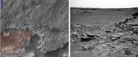
But it's not exactly a red carpet at the entrance.
-------------------- |
|
|
|
|
|
|
Sep 5 2014, 05:15 AM
Post
#230
|
|
 Member Group: Members Posts: 754 Joined: 9-February 07 Member No.: 1700 |
"not exactly a red carpet at the entrance" - tempted me to wonder how clear the threat is from what is visible in the image on the right in jmknapp's Post #229. Rereading Emily's (wonderful, as usual!) recent blog entry on wheel damage:
QUOTE Rover drivers are avoiding every pointy rock they can steer around. This only helps in the first 10 or 20 meters of a drive, where they can see smaller potentially hazardous rocks. On hazardous terrain, performing shorter drives allows them to avoid many potentially wheel-damaging rocks. I ask the experts: is there a safe-ish way through this entrance? |
|
|
|
|
Sep 5 2014, 12:22 PM
Post
#231
|
|
|
Senior Member Group: Members Posts: 2346 Joined: 7-December 12 Member No.: 6780 |
Driving forward over well-embedded hard and pointed rocks causes most of the damage.
By minimizing this kind of settings, the risk of damage can be managed. An approach to minimize fatigue caused by the overall roughness could be minimizing the integral of hardness times roughness over the path of the drive. Since the drive through this rough terrain is rather short, and there aren't too many embedded pointed rocks, it's reasonable to take this path. The terrain in the valley is much smoother, and making long detours would probably sum up to more damage, and waste more time than necessary. The expected science return of the Pahrump Hills is certainly worth to take some risk. The current outcrop is nice and interesting, too. That's at least my way to duplicate the decision, after quite some pondering the last few days, whether there may be a better path. This has been one of the first of just a few alternatives. |
|
|
|
|
Sep 5 2014, 02:31 PM
Post
#232
|
|
 Administrator Group: Admin Posts: 5172 Joined: 4-August 05 From: Pasadena, CA, USA, Earth Member No.: 454 |
I'm not too sure what the process of avoiding hazardous rocks looks like. One of the surprising things I learned, writing that article, is that something that looks like flagstones is far superior to wheel-chewing terrain. They have an 8-kilometer lifetime over the bad terrain, but 30-50 kilometer lifetime over flagstones. As long as bad rocks are far enough apart, they can really mitigate the threat of damage.
-------------------- My website - My Patreon - @elakdawalla on Twitter - Please support unmannedspaceflight.com by donating here.
|
|
|
|
|
Sep 5 2014, 05:50 PM
Post
#233
|
||
|
Senior Member Group: Members Posts: 1074 Joined: 21-September 07 From: Québec, Canada Member No.: 3908 |
Sol 739 mastcam view of Owens Valley:
|
|
|
|
|
|
|
Sep 5 2014, 06:10 PM
Post
#234
|
|
|
Member Group: Members Posts: 201 Joined: 16-December 13 Member No.: 7067 |
What a fantastic view!
Before and after the drive Anaglyph albums from yesterday and today: Sol 739 before the edge of the valley - Stretched Sol 740 on the edge of the valley - Stretched |
|
|
|
|
Sep 5 2014, 07:28 PM
Post
#235
|
|
|
Member Group: Members Posts: 334 Joined: 11-December 12 From: The home of Corby Crater (Corby-England) Member No.: 6783 |
QUOTE (jmknapp @ Sep 5 2014, 01:29 AM)  But it's not exactly a red carpet at the entrance. It's certainly rough and bumpy but not full of sharp damaging rocks though. The odd tip hazard!? A bit of wheel slip here and there!? The descent seems ok The question is, who wants to rule the sand pit? |
|
|
|
|
Sep 5 2014, 10:24 PM
Post
#236
|
|
|
Member Group: Members Posts: 910 Joined: 4-September 06 From: Boston Member No.: 1102 |
It is easy to loose track of the map showing where we are trying to go. Here is Joe's map from an earlier thread: Link
-------------------- |
|
|
|
|
Sep 5 2014, 10:24 PM
Post
#237
|
|
|
Senior Member Group: Members Posts: 1043 Joined: 17-February 09 Member No.: 4605 |
QUOTE (elakdawalla @ Sep 5 2014, 03:31 PM) They have an 8-kilometer lifetime over the bad terrain.... Mmmm, is that total or estimated remaining? |
|
|
|
|
Sep 5 2014, 11:02 PM
Post
#238
|
|
|
Senior Member Group: Members Posts: 2346 Joined: 7-December 12 Member No.: 6780 |
Only "total" makes really sense, otherwise it would need to be updated all the time. So subtract a few hundred meters for the remaining distance.
But it has been a conservative estimate, and it will probably become obsolete with the software update in about four months. Since they are already using a work-around, the number has become a theoretical value for a way of driving which is avoided. |
|
|
|
|
Sep 6 2014, 06:50 AM
Post
#239
|
|
|
Member Group: Members Posts: 809 Joined: 3-June 04 From: Brittany, France Member No.: 79 |
My take on the panorama of Amargosa Valley on sol 739:

-------------------- |
|
|
|
|
Sep 6 2014, 01:05 PM
Post
#240
|
|
|
Senior Member Group: Members Posts: 2346 Joined: 7-December 12 Member No.: 6780 |
|
|
|
|
|

|
Lo-Fi Version | Time is now: 27th April 2024 - 12:01 AM |
|
RULES AND GUIDELINES Please read the Forum Rules and Guidelines before posting. IMAGE COPYRIGHT |
OPINIONS AND MODERATION Opinions expressed on UnmannedSpaceflight.com are those of the individual posters and do not necessarily reflect the opinions of UnmannedSpaceflight.com or The Planetary Society. The all-volunteer UnmannedSpaceflight.com moderation team is wholly independent of The Planetary Society. The Planetary Society has no influence over decisions made by the UnmannedSpaceflight.com moderators. |
SUPPORT THE FORUM Unmannedspaceflight.com is funded by the Planetary Society. Please consider supporting our work and many other projects by donating to the Society or becoming a member. |
|