Chang'e-4 farside landing mission |

  |
Chang'e-4 farside landing mission |
 Jan 23 2020, 09:55 PM Jan 23 2020, 09:55 PM
Post
#301
|
||
|
Solar System Cartographer  Group: Members Posts: 10152 Joined: 5-April 05 From: Canada Member No.: 227 |
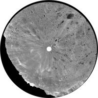
Thanks, Doug. This is Pan 30, 1 April 2019, in circular form (after a bit of cleaning up):
Comparison with the map shows it was taken at the same location as the end of day 4. Sunset was on 12 April but the rover was already at that location on 1 April after just one drive (I think) in the first 3 days after sunrise. Using arguments like these I am refining dates on the maps. Phil -------------------- ... because the Solar System ain't gonna map itself.
Also to be found posting similar content on https://mastodon.social/@PhilStooke Maps for download (free PD: https://upload.wikimedia.org/wikipedia/comm...Cartography.pdf NOTE: everything created by me which I post on UMSF is considered to be in the public domain (NOT CC, public domain) |
|
 |
 
|
|
|
Feb 1 2020, 07:38 PM
Post
#302
|
|
|
Solar System Cartographer Group: Members Posts: 10152 Joined: 5-April 05 From: Canada Member No.: 227 |
https://twitter.com/Yeqzids/status/1223647437300158464
This tweet (from one of our past students at Western) links to a big collection of PNG versions of the Chang'e 4 and Yutu 2 images, lots of goodies to play with. Phil -------------------- ... because the Solar System ain't gonna map itself.
Also to be found posting similar content on https://mastodon.social/@PhilStooke Maps for download (free PD: https://upload.wikimedia.org/wikipedia/comm...Cartography.pdf NOTE: everything created by me which I post on UMSF is considered to be in the public domain (NOT CC, public domain) |
|
|
|
|
Feb 1 2020, 07:54 PM
Post
#303
|
|
|
Solar System Cartographer Group: Members Posts: 10152 Joined: 5-April 05 From: Canada Member No.: 227 |
https://www.hou.usra.edu/meetings/lpsc2020/pdf/2153.pdf
And this LPSC abstract (thanks to Andrew Jones for pointing it out to me) has a map of Yutu 2's travels with those site or panorama numbers I was trying to map earlier. I think this makes it clear they are some kind of observation number, not just full panoramas but also local mosaics (like the impact glass crater) and maybe other things. Some sites have lots of observations, accounting for the apparently missing numbers Doug mentioned. Phil -------------------- ... because the Solar System ain't gonna map itself.
Also to be found posting similar content on https://mastodon.social/@PhilStooke Maps for download (free PD: https://upload.wikimedia.org/wikipedia/comm...Cartography.pdf NOTE: everything created by me which I post on UMSF is considered to be in the public domain (NOT CC, public domain) |
|
|
|
|
Feb 15 2020, 09:38 PM
Post
#304
|
|
|
Solar System Cartographer Group: Members Posts: 10152 Joined: 5-April 05 From: Canada Member No.: 227 |
A new paper in JGR-planets:
Lin, H., Xu, R., Yang, W., Lin, Y., Wei, Y., Hu, S., He, Z., Qiao, L. and Wan, W., In situ photometric experiment of lunar regolith with visible and near‐infrared imaging spectrometer onboard the Yutu‐2 lunar rover. Journal of Geophysical Research: Planets, p.e2019JE006076. explains something about the multiple observations at one target in particular. From 29 March to 1 April the rover performed a photometric experiment with its VNIS, calibrating it under different viewing angles as the rover turned in place. Phil -------------------- ... because the Solar System ain't gonna map itself.
Also to be found posting similar content on https://mastodon.social/@PhilStooke Maps for download (free PD: https://upload.wikimedia.org/wikipedia/comm...Cartography.pdf NOTE: everything created by me which I post on UMSF is considered to be in the public domain (NOT CC, public domain) |
|
|
|
|
Feb 17 2020, 06:00 PM
Post
#305
|
||
 Member Group: Members Posts: 185 Joined: 4-January 19 Member No.: 8523 |
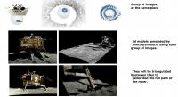
Thanks Phil for the twitter link to the PCAM and TCAM images, i'm just having great fun working with then. The Rover are taking blocks of images on a very nice pattern, on each stop position. This allow to create 3d models of position shots similar to laser Blocks. Then its just a matter of triangulating the "simulated laser blocks" and geting a very nice detailed terrain and objects models of Moon, Lander and Rover.
Attached thumbnail(s)
-------------------- "The Earth is a very small stage in a vast cosmic arena"
|
|
|
|
|
|
|
Feb 17 2020, 09:19 PM
Post
#306
|
|
|
Member Group: Members Posts: 156 Joined: 22-May 09 From: Ireland Member No.: 4792 |
While understanding parts of your graphic entirely, Huguet, which is excellent by the way, I do hope you will expand upon it in final description -- using the laser blocks.
I had a stab at what feature on the aerial view related to the 3D version...so forgive me if incorrect. Looks like, the OUTER blocks begin from a western position from 48 to 61 east in the top-half of the image in a clockwise direction, and the bottom-half from a western position from 34 to 47 in a counter-clockwise direction. The INNER blocks are different, in that they begin from a northern position - starting from 34 to 47 anti-clockwise, and from 48 to 61 clockwise. John Moore 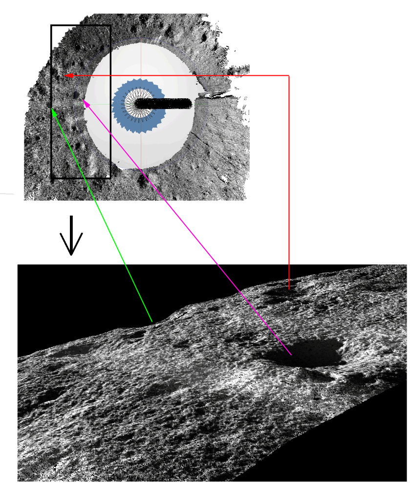
|
|
|
|
|
Feb 18 2020, 12:31 AM
Post
#307
|
||
|
Member Group: Members Posts: 185 Joined: 4-January 19 Member No.: 8523 |
Hi Jonh, The only mapping sensor they send with the rover was the PCAM cameras, usualy they could get stereo pairs on the rover direction all the time, but this would limit the mapping area and could generate more black zones without mapping. The best way to map a terrain, by ground view, would be with laser blocks. Its very simple, you just need to change the laser position and take a 360o (or a bubble) cloud of points. Every cloud or block has a internal perfect geometry, we just need to find 3 common points beetween two blocks to triangulate one with the other, and continue this process with the other blocks. They used this aproach with chang-e'4 rover. Simulating the laser blocks with angular photos with the stereo pcam cameras, inclinating the pcam support or using the rover rotation to expand the distance beetween the images, increasing the acuracy of each 3d block and avoiding black areas. Within the 5 GB of pics provided of the PCAM cameras, we have lots of group of images to generate 3D blocks. All we need to do is the photogrammetry to generate 3d models of each group of pics, and deal with this 3d models as we would deal with laser blocks, finding 3 common points beetween then and triangulating. This will generate a model with a resolution of more or less 1 point / cm2 of the path of the rover, including the lander model. This full cloud will need to be geo-referenced, we can make this using some know moon points like the center of some craters. I will isolate the blocks pics ids, the 3d blocks, a full cloud later and post here as RCS (Autocad), LAZ (Globalmapper) or PTS (Text File).
Attached thumbnail(s)
-------------------- "The Earth is a very small stage in a vast cosmic arena"
|
|
|
|
|
|
|
Feb 18 2020, 01:51 AM
Post
#308
|
|
|
Member Group: Members Posts: 156 Joined: 22-May 09 From: Ireland Member No.: 4792 |
Thanks again, Huguet...looks like 2D DEMs to 3D bubble DEMs...using laser block technology.
Perhaps, a 'Laser Block' DEM data resource, in the near future? John Moore |
|
|
|
|
Feb 22 2020, 04:44 AM
Post
#309
|
|
|
Solar System Cartographer Group: Members Posts: 10152 Joined: 5-April 05 From: Canada Member No.: 227 |
https://www.mdpi.com/2072-4292/12/4/624/pdf
This paper is very interesting in itself but also relevant to these recent posts. Rover route planning, with lots of images. Phil -------------------- ... because the Solar System ain't gonna map itself.
Also to be found posting similar content on https://mastodon.social/@PhilStooke Maps for download (free PD: https://upload.wikimedia.org/wikipedia/comm...Cartography.pdf NOTE: everything created by me which I post on UMSF is considered to be in the public domain (NOT CC, public domain) |
|
|
|
|
Feb 23 2020, 06:34 PM
Post
#310
|
|
|
Member Group: Members Posts: 156 Joined: 22-May 09 From: Ireland Member No.: 4792 |
Phil, thanks for that PDF link.
The below animation was generated from the 24-bit greyscale image on page 8, so the quality could be improved on, however, I don't have access to the higher 16-bits. The crater, in the paper, is said to be 8.7 metres in diameter, and the resolution is of 0.02 metres. White areas in the centre of the crater are missing data points (not water-ice deposits  ). ). John Moore 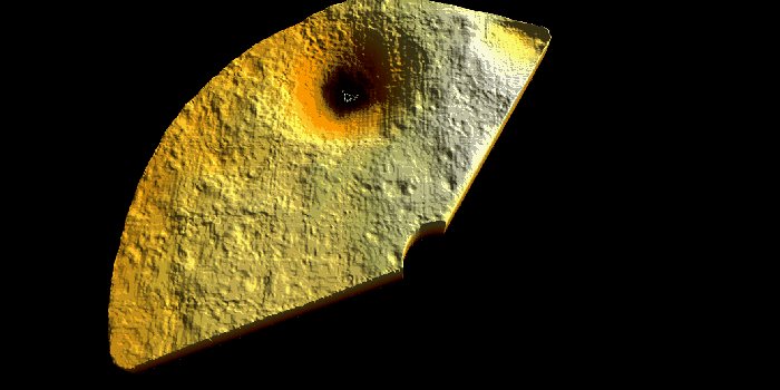
|
|
|
|
|
Feb 27 2020, 05:46 PM
Post
#311
|
|
|
Member Group: Members Posts: 866 Joined: 15-March 05 From: Santa Cruz, CA Member No.: 196 |
|
|
|
|
|
Mar 1 2020, 08:32 PM
Post
#312
|
|
|
Solar System Cartographer Group: Members Posts: 10152 Joined: 5-April 05 From: Canada Member No.: 227 |
Here:
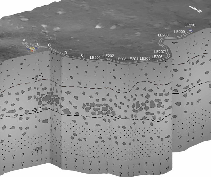
http://www.leonarddavid.com/chinas-penetra...e-moon-finding/ is a nice article about the radar findings from veteran space reported Leonard David. But check out the pictures from mission control. Everyone's wearing a mask, as we might expect, but the screen behind them has a great panorama from some recent date with the route marked on it, and just legible are designations for the night locations, S14, S13, S12 and so on. Other sources have shown the first 3 night locations labelled S1, S2, S3 so we have a well established pattern. Intermediate stops are being labelled in various ways (LE00201, LE201, N201 etc.), always using the Roman alphabet (and Arabic numbers). For 201, the lunar day is the first digit, the stop for that day is the third digit. Still no evidence of crater names but I live in hope (so far). Phil -------------------- ... because the Solar System ain't gonna map itself.
Also to be found posting similar content on https://mastodon.social/@PhilStooke Maps for download (free PD: https://upload.wikimedia.org/wikipedia/comm...Cartography.pdf NOTE: everything created by me which I post on UMSF is considered to be in the public domain (NOT CC, public domain) |
|
|
|
|
Mar 5 2020, 06:16 PM
Post
#313
|
|
|
Solar System Cartographer Group: Members Posts: 10152 Joined: 5-April 05 From: Canada Member No.: 227 |
https://mp.weixin.qq.com/s/uvyqkFUkrbh_mHbtZvEYBw
This link is to a post on day 15 of Yutu 2's mission. Open in something that will translate it for you if you need to. The story is that they were heading south to a prominent crater but have decided to turn northwest instead. 1800 m northwest of the rover is a patch of basalt which they want to investigate (it's buried under at least 40 m of ejecta where they are now). They hope to get there in a year or so, implying a huge increase in driving per lunar day and therefore less analysis along the way (presumably). First they have to drive around a large degraded crater about 150 m across and west of the current position (shown on my new map but more prominent in the images in the article). Phil -------------------- ... because the Solar System ain't gonna map itself.
Also to be found posting similar content on https://mastodon.social/@PhilStooke Maps for download (free PD: https://upload.wikimedia.org/wikipedia/comm...Cartography.pdf NOTE: everything created by me which I post on UMSF is considered to be in the public domain (NOT CC, public domain) |
|
|
|
|
Mar 5 2020, 10:03 PM
Post
#314
|
|
|
Member Group: Members Posts: 156 Joined: 22-May 09 From: Ireland Member No.: 4792 |
Below, a GLD100 (+LOLA) slope comparison.
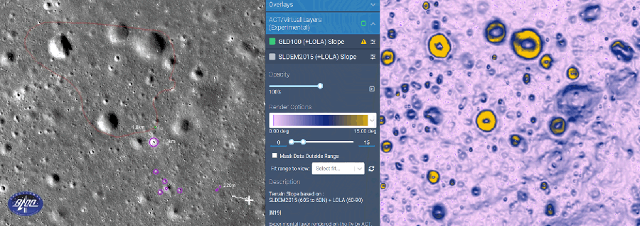 The old Geological data doesn't yield that much  John Moore |
|
|
|
|
Mar 20 2020, 01:56 AM
Post
#315
|
|
|
Solar System Cartographer Group: Members Posts: 10152 Joined: 5-April 05 From: Canada Member No.: 227 |
Here is a very interesting forum thread on the Chinese 9ifly forum, full of details about the mission and (at the moment) being updated as needed.
http://www.9ifly.cn/thread-93232-1-1.html Open in something that will translate it for you if you need to. Yutu 2 just woke up for its 16th lunar day and exceeded the 400 m mark on its traverse. Phil -------------------- ... because the Solar System ain't gonna map itself.
Also to be found posting similar content on https://mastodon.social/@PhilStooke Maps for download (free PD: https://upload.wikimedia.org/wikipedia/comm...Cartography.pdf NOTE: everything created by me which I post on UMSF is considered to be in the public domain (NOT CC, public domain) |
|
|
|
|

|
Lo-Fi Version | Time is now: 26th April 2024 - 09:21 PM |
|
RULES AND GUIDELINES Please read the Forum Rules and Guidelines before posting. IMAGE COPYRIGHT |
OPINIONS AND MODERATION Opinions expressed on UnmannedSpaceflight.com are those of the individual posters and do not necessarily reflect the opinions of UnmannedSpaceflight.com or The Planetary Society. The all-volunteer UnmannedSpaceflight.com moderation team is wholly independent of The Planetary Society. The Planetary Society has no influence over decisions made by the UnmannedSpaceflight.com moderators. |
SUPPORT THE FORUM Unmannedspaceflight.com is funded by the Planetary Society. Please consider supporting our work and many other projects by donating to the Society or becoming a member. |
|