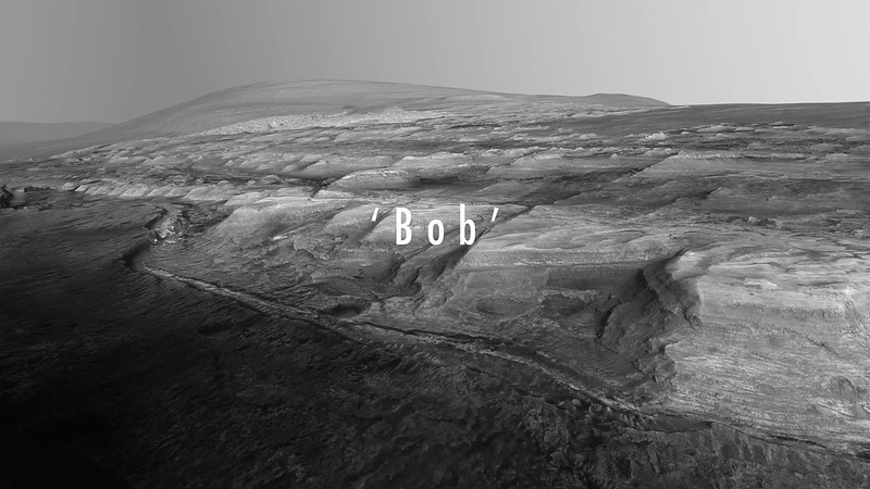
The Top of Vera Rubin Ridge Part 1, Site 66-67, sol 1812-1943, 11 Sep 2017-23 Jan 2018 |

  |
The Top of Vera Rubin Ridge Part 1, Site 66-67, sol 1812-1943, 11 Sep 2017-23 Jan 2018 |
 Dec 16 2017, 01:17 PM Dec 16 2017, 01:17 PM
Post
#226
|
|
 Senior Member  Group: Members Posts: 1619 Joined: 12-February 06 From: Bergerac - FR Member No.: 678 |
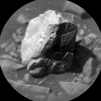
Sol 1905 panoramic
-------------------- |
 |
 
|
|
Dec 17 2017, 05:57 AM
Post
#227
|
||
 Senior Member Group: Members Posts: 2428 Joined: 30-January 13 From: Penang, Malaysia. Member No.: 6853 |
QUOTE (Ant103 @ Dec 16 2017, 09:17 PM)  Sol 1905 panoramic Expertly crafted Damia 1906 RMI of an interesting little target. Not quite sure if ithe material on the left side is a thick mineral filled fracture, or another rock type, therefore an interface between two rocks. Leaning towards mineral filled fracture material
|
|
|
|
|
|
|
Dec 17 2017, 11:44 AM
Post
#228
|
||
|
Senior Member Group: Members Posts: 2428 Joined: 30-January 13 From: Penang, Malaysia. Member No.: 6853 |
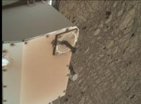
Unusually close to the sun dial in this MAHLI from 1904, much closer than the distance used for a Selfie, and focused on the ground. Hopefully the backdated weekend plan will be issued in a day or two will shed some light on what they were aiming to capture.
EDIT: They acquired another image with the sundial in focus, mystery solved?
|
|
|
|
|
|
|
Dec 17 2017, 02:51 PM
Post
#229
|
||
|
Senior Member Group: Members Posts: 2511 Joined: 13-September 05 Member No.: 497 |
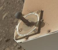
This is the best image of the cal target I've seen, and you can see the "MARS 2010" that we didn't update after the launch slip.
-------------------- Disclaimer: This post is based on public information only. Any opinions are my own.
|
|
|
|
|
|
|
Dec 18 2017, 01:29 AM
Post
#230
|
|
|
Senior Member Group: Members Posts: 2082 Joined: 13-February 10 From: Ontario Member No.: 5221 |
Cool! I suppose there's a good reason this sort of imaging hasn't been done until this far into the mission?
|
|
|
|
|
Dec 18 2017, 08:17 PM
Post
#231
|
|
|
Member Group: Members Posts: 923 Joined: 10-November 15 Member No.: 7837 |
Here is a partial glimpse of the epic panorama waiting in the wings.... MSL 1903 ML
 -------------------- |
|
|
|
|
Dec 18 2017, 09:40 PM
Post
#232
|
|
 Member Group: Members Posts: 809 Joined: 3-June 04 From: Brittany, France Member No.: 79 |
And my take on this awesome early morning panorama that is coming... Sol 1903, 8h07 local time.
-------------------- |
|
|
|
|
Dec 18 2017, 11:02 PM
Post
#233
|
|
|
Senior Member Group: Members Posts: 2428 Joined: 30-January 13 From: Penang, Malaysia. Member No.: 6853 |
1903 is going to be a outstanding 360. My previews all failed to pass internal QC, so I delighted to see these stunning teasers, plus I saw that Damia is working on de-bayering this set as well.
Further good news is that the team have ensured we can fill in the gaps on the 360 with a full suite of NavCam's of the deck. Hopefully the remaining images will make it to JPL soon, I'm really looking forward to seeing all the different versions Keep up the excellent processing |
|
|
|
|
Dec 19 2017, 12:56 PM
Post
#234
|
|
|
Member Group: Members Posts: 362 Joined: 13-April 06 From: Malta Member No.: 741 |
It might be premature to ask but any working hypothesis as to the origin of Rubin ridge?
|
|
|
|
|
Dec 19 2017, 01:04 PM
Post
#235
|
|
|
Senior Member Group: Members Posts: 1619 Joined: 12-February 06 From: Bergerac - FR Member No.: 678 |
And, to complete the trio.
 -------------------- |
|
|
|
|
Dec 19 2017, 03:37 PM
Post
#236
|
|
|
Member Group: Members Posts: 122 Joined: 19-June 07 Member No.: 2455 |
In all those wonderful photos there's a ridge ahead with a rock layer on top and steep walls below it. I see no obvious places to climb over it in the wide section we are seeing. Is our path off to the left of what we're looking at with a gradual slope somewhere?
|
|
|
|
|
Dec 19 2017, 05:59 PM
Post
#237
|
|
|
Member Group: Members Posts: 923 Joined: 10-November 15 Member No.: 7837 |
Click thru for a video of the horizon area featured in the recent pano...
 And in delicious 4k on Youtube More on the route ahead... 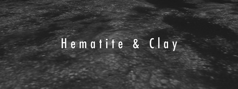 -------------------- |
|
|
|
|
Dec 19 2017, 09:55 PM
Post
#238
|
|
|
Senior Member Group: Members Posts: 1043 Joined: 17-February 09 Member No.: 4605 |
[quote name='Art Martin' date='Dec 19 2017, 03:37 PM' post='238015']
... there's a ridge ahead with a rock layer on top and steep walls below it. I see no obvious places to climb over it... [/quote That ridge is a remnant of what Anderson and Bell termed the "mound skirting unit" which was protected by fan material from the channel, now eroded back. If you watch Sean's impressive video titled Hematite and Clay, towards the end the rather benign area of the proposed path, towards at the rear left side of the fan is visible (around time stamp 1.45). |
|
|
|
|
Dec 19 2017, 10:12 PM
Post
#239
|
|
|
Member Group: Members Posts: 923 Joined: 10-November 15 Member No.: 7837 |
I think I recall this is the area where Curi will ascend...just before the dunes on the left
 Hopefully 'The Stooke' or Fernando will confirm or correct.
-------------------- |
|
|
|
|
Dec 20 2017, 03:07 AM
Post
#240
|
||
|
Senior Member Group: Members Posts: 1043 Joined: 17-February 09 Member No.: 4605 |
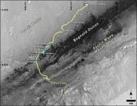
Around past the dunes I believe, unless they have significantly changed the basic route. Image from https://www.nasa.gov/image-feature/jpl/pia2...xtended-mission
Attached thumbnail(s)
|
|
|
|
|
|
|

|
Lo-Fi Version | Time is now: 30th April 2024 - 08:07 AM |
|
RULES AND GUIDELINES Please read the Forum Rules and Guidelines before posting. IMAGE COPYRIGHT |
OPINIONS AND MODERATION Opinions expressed on UnmannedSpaceflight.com are those of the individual posters and do not necessarily reflect the opinions of UnmannedSpaceflight.com or The Planetary Society. The all-volunteer UnmannedSpaceflight.com moderation team is wholly independent of The Planetary Society. The Planetary Society has no influence over decisions made by the UnmannedSpaceflight.com moderators. |
SUPPORT THE FORUM Unmannedspaceflight.com is funded by the Planetary Society. Please consider supporting our work and many other projects by donating to the Society or becoming a member. |
|