The Top of Vera Rubin Ridge Part 2, Site 67-73, sol 1944-2297, 24 Jan 2018-22 Jan 2019 |

  |
The Top of Vera Rubin Ridge Part 2, Site 67-73, sol 1944-2297, 24 Jan 2018-22 Jan 2019 |
 Nov 10 2018, 08:00 PM Nov 10 2018, 08:00 PM
Post
#571
|
||
|
Senior Member  Group: Members Posts: 2820 Joined: 22-April 05 From: Ridderkerk, Netherlands Member No.: 353 |
The Navcam L A view on Sol 2221.
Jan van Driel
|
|
 |
 
|
|
|
Nov 10 2018, 09:48 PM
Post
#572
|
|
|
Senior Member Group: Members Posts: 1043 Joined: 17-February 09 Member No.: 4605 |
QUOTE (PaulH51 @ Nov 10 2018, 08:43 AM)  ...Hopefully this completes the full set of samples from the ridge...... Well a truncated set of samples. They have not been able to obtain a sample of the hard areas of the ridge so full analysis as to why it is so tough will be a tad difficult. |
|
|
|
|
Nov 11 2018, 01:39 PM
Post
#573
|
|
|
Senior Member Group: Members Posts: 2346 Joined: 7-December 12 Member No.: 6780 |
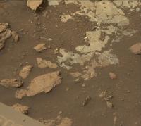
QUOTE (PaulH51 @ Nov 10 2018, 10:43 AM) Just in: Our first look at the sample hole at 'Highfield' in raw colour. R-MastCam, sol 2224. Hopefully this completes the full set of samples from the ridge and we can soon head into the Clay Trough  One mystery remains to be resolved: Where is the hematite presumably detected from orbit? The drill tailings look fairly grey. Might the hard, drill-resistent rock be richer in hematite? |
|
|
|
|
Nov 11 2018, 03:20 PM
Post
#574
|
|
 Member Group: Members Posts: 684 Joined: 24-July 15 Member No.: 7619 |
QUOTE (Gerald @ Nov 11 2018, 01:39 PM) One mystery remains to be resolved: Where is the hematite presumably detected from orbit? The drill tailings look fairly grey. Might the hard, drill-resistent rock be richer in hematite? It takes a while for bulk grey stone to weather to red dust. QUOTE Deposits of grey hematite are typically found in places where there has been standing water or mineral hot springs, such as those in Yellowstone.
https://mars.nasa.gov/mer/spotlight/hematite01.html  |
|
|
|
|
Nov 11 2018, 09:21 PM
Post
#575
|
||
|
Solar System Cartographer Group: Members Posts: 10151 Joined: 5-April 05 From: Canada Member No.: 227 |
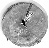
This is Jan's panorama for sol 2221 in a circular projection. The next sol saw us move to the bright rock outcrop.
Phil
-------------------- ... because the Solar System ain't gonna map itself.
Also to be found posting similar content on https://mastodon.social/@PhilStooke Maps for download (free PD: https://upload.wikimedia.org/wikipedia/comm...Cartography.pdf NOTE: everything created by me which I post on UMSF is considered to be in the public domain (NOT CC, public domain) |
|
|
|
|
|
|
Nov 11 2018, 09:38 PM
Post
#576
|
|
|
Senior Member Group: Members Posts: 1043 Joined: 17-February 09 Member No.: 4605 |
It takes a while for bulk grey stone to weather to red dust
I suspect Gerald is referring to the red scratch test effect that occurred with Opportunity's RAT on hematite rich material. |
|
|
|
|
Nov 11 2018, 10:21 PM
Post
#577
|
|
|
Member Group: Members Posts: 684 Joined: 24-July 15 Member No.: 7619 |
QUOTE ('serpens' date='Nov 11 2018 @ 09:38 PM' post='241760') QUOTE (HSchirmer) It takes a while for bulk grey stone to weather to red dust I suspect Gerald is referring to the red scratch test effect that occurred with Opportunity's RAT on hematite rich material. Well, FWIW, i'm an amateur geologist (less than two miles from the red-stone quarry where Shyamalan filmed the earth bender segments.) I'm not first-hand familar with tilling Mars dirt, but I'm quite familiar with how grey-stone, and blue-stone in my driveway and backyard weathers to red-stone. It takes a while. |
|
|
|
|
Nov 11 2018, 11:47 PM
Post
#578
|
||
 Senior Member Group: Members Posts: 2428 Joined: 30-January 13 From: Penang, Malaysia. Member No.: 6853 |
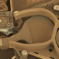
Looks like this may have been a test sample drop on one of the instrument inlet covers on sol 2225
Cropped animation from 2 L-MastCam frames
|
|
|
|
|
|
|
Nov 12 2018, 03:02 AM
Post
#579
|
|
|
Senior Member Group: Members Posts: 2346 Joined: 7-December 12 Member No.: 6780 |
QUOTE (serpens @ Nov 11 2018, 11:38 PM) It takes a while for bulk grey stone to weather to red dust I suspect Gerald is referring to the red scratch test effect that occurred with Opportunity's RAT on hematite rich material. You are right, of course, Serpens, hematite powder is always red-orange, no matter what's the color of the bulk mineral or rock. If hematite abundance would be more than about 5%, this should be pretty obvious from images of the drill tailings. Pure crystalline hematite is pretty hard. So, tailings would be fine enough to make us evidently see the orange color. Finely dispersed (matrix) hematite in a rock would colorize the rock red to orangish. LIBS, presumably, and APXS surely, would indicate a high iron abundance, too. Vera Rubin Ridge was formerly known as Hematite Ridge due to CRISM data. So, how consistent are CRISM data (e.g. page 6 of this presentation) with in-situ measurements? At least, a bruhed rock on Lower Vera Rubin Ridge (slide 9 of the same presentation) showed the expected composition and color. But elsewhere on Vera Rubin Ridge, we appear to be almost free of iron-bearing minerals. That's a bit confusing. Did I overlook something? |
|
|
|
|
Nov 12 2018, 04:51 AM
Post
#580
|
|||
|
Member Group: Members Posts: 306 Joined: 4-October 14 Member No.: 7273 |
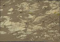
Keep in mind that CRISM is averaging over an area of at least 15 m per pixel and is only able to examine very surface of the rock. A hematite detection doesn't mean that the hematite is evenly distributed within a pixel, or even a bedrock component. The regolith around Curiosity is full of *very* red clasts and sand, and that might be what CRISM is seeing from orbit.
Since there are scattered (likely) hematite-bearing patches of rock in the Upper VRR / Jura mbr, those materials might be sourced from hematite-bearing patches of rock in the Upper VRR / Jura mbr. Here's an image where you can see a potential transition from the generally blue-gray rocks into a deeper red consistent with hematite from back on Sol 2156:
|
||
|
|
|
||
|
Nov 12 2018, 05:28 AM
Post
#581
|
|
|
Senior Member Group: Members Posts: 1043 Joined: 17-February 09 Member No.: 4605 |
But elsewhere on Vera Rubin Ridge, we appear to be almost free of iron-bearing minerals. That's a bit confusing. Did I overlook something?
Well we know that the Jura member is not homogeneous with red and grey patches which appear to correlate to degree of toughness of the rock. The drill friendly grey patches may simply lack hematite. This drill location seems somewhat blocky and I wonder whether these blue/grey patches are lenses similar to the Pahrump hills examples I referred to in Post #559. Pure conjecture and we will find out more when the CheMin results are published. |
|
|
|
|
Nov 12 2018, 11:33 AM
Post
#582
|
||
|
Senior Member Group: Members Posts: 2346 Joined: 7-December 12 Member No.: 6780 |
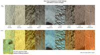
In order to get an idea of the composition of the drilled rock, I've compared the color of the drill tailings in Paul's Sol 2224 MR image with early drill tailings taken by MAHLI:
With all due caution due to the rather different spectral characteristics of the two cameras, I'm almost inclined to presume, that the new drill target might be rather rich in phyllosilicates. So, might be, that the hematite detected by CRISM is actually located mostly in the regolith covering much of upper VRR. And we may find abundant phyllosilicates already here on VRR, before even driving further to Phyllosilicate Trough. If this presumption will turn out to hold, the according conditions of rock formation may have been moderately reducing, and almost neutral, rather than oxidizing like assumed for hematite formation. This very preliminary attempt to infer composition requires confirmation with MAHLI images in a first step, and eventually a much more accurate CheMin analysis. From this very preliminary point of view, it may actually be reasonable to stay on VRR for some more time, and to learn more about the transition between the redder, presumably hematite-rich oxidized rock, and the soft, presumably clay-mineral bearing reduced bedrock. |
|
|
|
|
|
|
Nov 12 2018, 12:29 PM
Post
#583
|
||
|
Senior Member Group: Members Posts: 2428 Joined: 30-January 13 From: Penang, Malaysia. Member No.: 6853 |
Before driving up to the 'Highfield' drill site Curiosity acquired these 12 overlapping sol 2222 R-MastCam frames that feature the terrain around Highfield, Lake Orcadie and Lake Orcadie 2. This 4x3 mosaic of raw images (4483 x 3101) was roughly assembled in MS ICE and annotated with the locations of the drill sites (based on Phil's earlier post showing just how close the sites are together)
|
|
|
|
|
|
|
Nov 12 2018, 02:13 PM
Post
#584
|
|
|
Member Group: Members Posts: 684 Joined: 24-July 15 Member No.: 7619 |
QUOTE (serpens) One mystery remains to be resolved: Where is the hematite presumably detected from orbit? The drill tailings look fairly grey. Might the hard, drill-resistent rock be richer in hematite? HSchirmer- It takes a while for bulk grey stone to weather to red dust. If the rock is a mixture of hard grey hematite and softer grey shale, then the drill tailings should be grey. The grey shale breaks up before the grey hematite does. IIRC, the drill is designed to efficiently chip and remove rock, not grind it into fine dust. A recent paper suggests that VRR may be regular murray formation material that is harder. One possibility is that it was compressed under the edge of Mount Sharp, then excavated, then reburied (so, it's twice-baked and harder) CHARACTERISTICS AND THE ORIGIN OF THE VERA RUBIN RIDGE,GALE CRATER, MARS https://www.hou.usra.edu/meetings/lpsc2018/pdf/1817.pdf |
|
|
|
|
Nov 12 2018, 02:43 PM
Post
#585
|
||
|
Senior Member Group: Members Posts: 2820 Joined: 22-April 05 From: Ridderkerk, Netherlands Member No.: 353 |
The Navcam L A view on Sol 2222.
Jan van Driel
|
|
|
|
|
|
|

|
Lo-Fi Version | Time is now: 26th April 2024 - 02:21 PM |
|
RULES AND GUIDELINES Please read the Forum Rules and Guidelines before posting. IMAGE COPYRIGHT |
OPINIONS AND MODERATION Opinions expressed on UnmannedSpaceflight.com are those of the individual posters and do not necessarily reflect the opinions of UnmannedSpaceflight.com or The Planetary Society. The all-volunteer UnmannedSpaceflight.com moderation team is wholly independent of The Planetary Society. The Planetary Society has no influence over decisions made by the UnmannedSpaceflight.com moderators. |
SUPPORT THE FORUM Unmannedspaceflight.com is funded by the Planetary Society. Please consider supporting our work and many other projects by donating to the Society or becoming a member. |
|