InSight Surface Operations, 26 Nov 2018- 21 Dec 2022 |

  |
InSight Surface Operations, 26 Nov 2018- 21 Dec 2022 |
 Dec 20 2018, 03:20 AM Dec 20 2018, 03:20 AM
Post
#316
|
|
 Member  Group: Members Posts: 684 Joined: 24-July 15 Member No.: 7619 |
QUOTE (atomoid @ Dec 20 2018, 02:37 AM)  i'm curious what the 'EDR' as well as the 'M' at the end represent. Fairly sure EDR is "Experiment Data Record" |
 |
 
|
|
Dec 20 2018, 03:53 AM
Post
#317
|
|
|
Forum Contributor Group: Members Posts: 1372 Joined: 8-February 04 From: North East Florida, USA. Member No.: 11 |
QUOTE (atomoid @ Dec 20 2018, 03:37 AM) I never was able to get Cargo Cult's walkabout VR version of InSight's landing site working, just brings up a simple image, perhaps i need SteamVR equipment or something like that? Yes you need VR equipment. |
|
|
|
|
Dec 20 2018, 04:26 AM
Post
#318
|
|
|
Solar System Cartographer Group: Members Posts: 10158 Joined: 5-April 05 From: Canada Member No.: 227 |
EDR, the Experiment Data Record, is the actual data from the spacecraft as received. It has not been calibrated, cleaned of noise or processed in any other way, and in the case of an image not map-projected (for instance, LRO Camera EDRs are often a mirror-image of the map-projected version, which causes new users no end of confusion). The original file for these InSight images is the EDR, and strictly speaking we are not getting that in the public release but it's what the science team have.
Phil -------------------- ... because the Solar System ain't gonna map itself.
Also to be found posting similar content on https://mastodon.social/@PhilStooke Maps for download (free PD: https://upload.wikimedia.org/wikipedia/comm...Cartography.pdf NOTE: everything created by me which I post on UMSF is considered to be in the public domain (NOT CC, public domain) |
|
|
|
|
Dec 20 2018, 05:25 AM
Post
#319
|
|||
 Senior Member Group: Members Posts: 2428 Joined: 30-January 13 From: Penang, Malaysia. Member No.: 6853 |
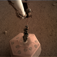
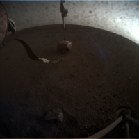
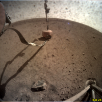
Sol 22, SEIS is on the ground
|
||
|
|
|
||
|
Dec 20 2018, 05:52 AM
Post
#320
|
|
|
Merciless Robot Group: Admin Posts: 8783 Joined: 8-December 05 From: Los Angeles Member No.: 602 |
Congratulations to the team!!!!! Most significant mission milestone since touchdown!
-------------------- A few will take this knowledge and use this power of a dream realized as a force for change, an impetus for further discovery to make less ancient dreams real.
|
|
|
|
|
Dec 20 2018, 05:53 AM
Post
#321
|
||
|
Member Group: Members Posts: 201 Joined: 16-December 13 Member No.: 7067 |
animation of the deployment. the tether looks blurred in the frame after it releases from the deck
|
|
|
|
|
|
|
Dec 20 2018, 06:26 AM
Post
#322
|
||
|
Senior Member Group: Members Posts: 2428 Joined: 30-January 13 From: Penang, Malaysia. Member No.: 6853 |
My take on the SEIS deployment GIF, I added the timestamps and brightened each of the sol 22 frames a little.
|
|
|
|
|
|
|
Dec 20 2018, 06:32 AM
Post
#323
|
|
|
Forum Contributor Group: Members Posts: 1372 Joined: 8-February 04 From: North East Florida, USA. Member No.: 11 |
I thought the deployment would have been so much slower with stops at many locations to check things, looks like it was one smooth deployment movement.
|
|
|
|
|
Dec 20 2018, 07:30 AM
Post
#324
|
|
|
Solar System Cartographer Group: Members Posts: 10158 Joined: 5-April 05 From: Canada Member No.: 227 |
I will just mention that I am working on a site map and will post it when I can.
Phil -------------------- ... because the Solar System ain't gonna map itself.
Also to be found posting similar content on https://mastodon.social/@PhilStooke Maps for download (free PD: https://upload.wikimedia.org/wikipedia/comm...Cartography.pdf NOTE: everything created by me which I post on UMSF is considered to be in the public domain (NOT CC, public domain) |
|
|
|
|
Dec 20 2018, 07:40 AM
Post
#325
|
|
|
Member Group: Members Posts: 470 Joined: 24-March 04 From: Finland Member No.: 63 |
Probably they figure that it is less risky to do the deployment in one (well practised) move, than leaving the instrument dangling on the tether for longer periods of time.
Congratulations to the team! -------------------- Antti Kuosmanen
|
|
|
|
|
Dec 20 2018, 01:06 PM
Post
#326
|
|
|
Senior Member Group: Members Posts: 2428 Joined: 30-January 13 From: Penang, Malaysia. Member No.: 6853 |
|
|
|
|
|
Dec 20 2018, 02:52 PM
Post
#327
|
|
|
Senior Member Group: Members Posts: 1582 Joined: 14-October 05 From: Vermont Member No.: 530 |
With instruments in the FOV, the dust on the camera really isn't as bad as it appeared with only dirt and gravel of the same hue in the FOV.
Also, it's funny to think back on this being called slow-ish. Seems like lightning speed! |
|
|
|
|
Dec 20 2018, 03:01 PM
Post
#328
|
|
|
Senior Member Group: Members Posts: 2084 Joined: 13-February 10 From: Ontario Member No.: 5221 |
Wonderful news! And if it seems fast, it did take a whole Martian day to do this.
Judging from the press release, the heat flow probe will go on the far right of the work space to have as much distance from SEIS as possible? Seems a bit more rocky on that side though... EDIT: nevermind looks like it will be on the left, actually, judging by this (https://twitter.com/NASAInSight/status/1075559676069048320) C was the final spot for SEIS, so HP3 might go around the H area. |
|
|
|
|
Dec 20 2018, 06:38 PM
Post
#329
|
|
|
Solar System Cartographer Group: Members Posts: 10158 Joined: 5-April 05 From: Canada Member No.: 227 |
I think the A or E areas are what is intended, based on the rendered images of deployed instruments.
Phil -------------------- ... because the Solar System ain't gonna map itself.
Also to be found posting similar content on https://mastodon.social/@PhilStooke Maps for download (free PD: https://upload.wikimedia.org/wikipedia/comm...Cartography.pdf NOTE: everything created by me which I post on UMSF is considered to be in the public domain (NOT CC, public domain) |
|
|
|
|
Dec 20 2018, 07:19 PM
Post
#330
|
|
 Member Group: Members Posts: 691 Joined: 21-December 07 From: Clatskanie, Oregon Member No.: 3988 |
Looking at the deployed Seismometer on the ground, one thing occurred to me. Wouldn't the flex-cable moving around in the wind impart some minor vibrations into the instrument? Are there any isolation mechanisms on the cable interface into the instrument that will help mitigate that?
|
|
|
|
|

|
Lo-Fi Version | Time is now: 5th May 2024 - 01:50 PM |
|
RULES AND GUIDELINES Please read the Forum Rules and Guidelines before posting. IMAGE COPYRIGHT |
OPINIONS AND MODERATION Opinions expressed on UnmannedSpaceflight.com are those of the individual posters and do not necessarily reflect the opinions of UnmannedSpaceflight.com or The Planetary Society. The all-volunteer UnmannedSpaceflight.com moderation team is wholly independent of The Planetary Society. The Planetary Society has no influence over decisions made by the UnmannedSpaceflight.com moderators. |
SUPPORT THE FORUM Unmannedspaceflight.com is funded by the Planetary Society. Please consider supporting our work and many other projects by donating to the Society or becoming a member. |
|