Atop/Around the Greenheugh Pediment, Site 79-, sol 2695-3199, 3 Mar 2020-6 Aug 2021 |

  |
Atop/Around the Greenheugh Pediment, Site 79-, sol 2695-3199, 3 Mar 2020-6 Aug 2021 |
 Jul 12 2020, 11:35 AM Jul 12 2020, 11:35 AM
Post
#201
|
||
|
Senior Member  Group: Members Posts: 2836 Joined: 22-April 05 From: Ridderkerk, Netherlands Member No.: 353 |
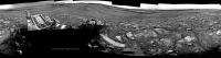
and the view on Sol 2817.
Jan van Driel
|
|
 |
 
|
|
|
Jul 13 2020, 11:40 AM
Post
#202
|
||
|
Senior Member Group: Members Posts: 2836 Joined: 22-April 05 From: Ridderkerk, Netherlands Member No.: 353 |
The Navcam L view on Sol 2820.
Jan van Driel
|
|
|
|
|
|
|
Jul 13 2020, 07:28 PM
Post
#203
|
||
|
Senior Member Group: Members Posts: 2836 Joined: 22-April 05 From: Ridderkerk, Netherlands Member No.: 353 |
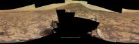
The MASTcam L view on Sol 2789.
Jan van Driel
|
|
|
|
|
|
|
Jul 14 2020, 01:24 AM
Post
#204
|
||
|
Newbie Group: Members Posts: 1 Joined: 4-March 09 Member No.: 4623 |
QUOTE (jvandriel @ Jul 13 2020, 08:28 PM)  The MASTcam L view on Sol 2789. Thank you so much for posting these images. I've been experimenting with getting these 360 degree (?) images into a form viewable VR headset by placing them in the middle of the equirectangular format required by the headsets (e.g. 6000 x 3000 pixels), but the image looks warped regardless where I place (and scale it) in the image format I've tried shifting it upwards and downwards, but it still doesn't look right. (See example atttached to this post). Do you have any idea whether I need to stretch the image differently to compansate for differences in projection etc, or place it in a certain position in the equirect for it to be correctly projected? Any ideas on how to get this right would be very welcome!
|
|
|
|
|
|
|
Jul 14 2020, 06:56 AM
Post
#205
|
||
|
Solar System Cartographer Group: Members Posts: 10172 Joined: 5-April 05 From: Canada Member No.: 227 |
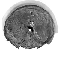
Jan's sol 2020 panorama in circular format.
Phil
-------------------- ... because the Solar System ain't gonna map itself.
Also to be found posting similar content on https://mastodon.social/@PhilStooke Maps for download (free PD: https://upload.wikimedia.org/wikipedia/comm...Cartography.pdf NOTE: everything created by me which I post on UMSF is considered to be in the public domain (NOT CC, public domain) |
|
|
|
|
|
|
Jul 15 2020, 03:25 AM
Post
#206
|
|||
|
Solar System Cartographer Group: Members Posts: 10172 Joined: 5-April 05 From: Canada Member No.: 227 |
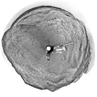
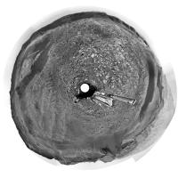
And these are the previous two Navcam panoramas from Jan in circular form.
Phil sol 2816:
sol 2817:
-------------------- ... because the Solar System ain't gonna map itself.
Also to be found posting similar content on https://mastodon.social/@PhilStooke Maps for download (free PD: https://upload.wikimedia.org/wikipedia/comm...Cartography.pdf NOTE: everything created by me which I post on UMSF is considered to be in the public domain (NOT CC, public domain) |
||
|
|
|
||
|
Jul 15 2020, 11:03 AM
Post
#207
|
|
|
Member Group: Members Posts: 923 Joined: 10-November 15 Member No.: 7837 |
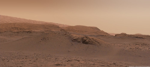
A Navcam portrait of Vera Rubin Ridge on Sol 02820...

-------------------- |
|
|
|
|
Jul 16 2020, 05:02 PM
Post
#208
|
||
|
Senior Member Group: Members Posts: 2836 Joined: 22-April 05 From: Ridderkerk, Netherlands Member No.: 353 |
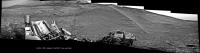
Partial view of the Sol 2822 Navcam L panorama.
The rest of the images will be added later. Jan van Driel
|
|
|
|
|
|
|
Jul 17 2020, 06:33 AM
Post
#209
|
||
 Senior Member Group: Members Posts: 2429 Joined: 30-January 13 From: Penang, Malaysia. Member No.: 6853 |
Another quick and dirty stitch from MS-ICE, this time from sol 2824, that may assist in narrowing down the new location (L-NavCam)
|
|
|
|
|
|
|
Jul 17 2020, 11:08 AM
Post
#210
|
||
|
Senior Member Group: Members Posts: 2836 Joined: 22-April 05 From: Ridderkerk, Netherlands Member No.: 353 |
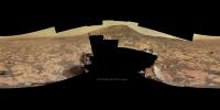
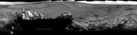
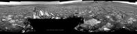
and the complete Sol 2822 NAVcam L view.
Jan van Driel
|
|
|
|
|
|
|
Jul 17 2020, 12:55 PM
Post
#211
|
||
|
Senior Member Group: Members Posts: 2836 Joined: 22-April 05 From: Ridderkerk, Netherlands Member No.: 353 |
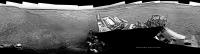
and the NAVcam L view on Sol 2824.
Jan van Driel
|
|
|
|
|
|
|
Jul 17 2020, 08:07 PM
Post
#212
|
||
|
Solar System Cartographer Group: Members Posts: 10172 Joined: 5-April 05 From: Canada Member No.: 227 |
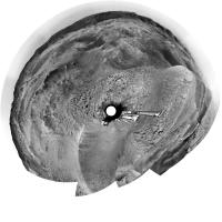
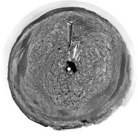
Thanks, Jan. This is the sol 2824 panorama in circular form. I used it to update the map.
Phil
-------------------- ... because the Solar System ain't gonna map itself.
Also to be found posting similar content on https://mastodon.social/@PhilStooke Maps for download (free PD: https://upload.wikimedia.org/wikipedia/comm...Cartography.pdf NOTE: everything created by me which I post on UMSF is considered to be in the public domain (NOT CC, public domain) |
|
|
|
|
|
|
Jul 22 2020, 12:12 PM
Post
#213
|
|
 Member Group: Members Posts: 810 Joined: 3-June 04 From: Brittany, France Member No.: 79 |
Mosaic of 3 MastCam Left pictures taken on sol 2826 (18 July) at 12:10 pm martian local time:
 And an older one taken on sol 2816 (8 July) with MastCam Right at 12:50 pm martian local time: 
-------------------- |
|
|
|
|
Jul 22 2020, 05:45 PM
Post
#214
|
||
|
Senior Member Group: Members Posts: 2836 Joined: 22-April 05 From: Ridderkerk, Netherlands Member No.: 353 |
The Navcam L view on Sol 2829.
Jan van Driel
|
|
|
|
|
|
|
Jul 22 2020, 06:27 PM
Post
#215
|
||
|
Solar System Cartographer Group: Members Posts: 10172 Joined: 5-April 05 From: Canada Member No.: 227 |
Jan's panorama in circular form - we moved north about 15 m.
Phil
-------------------- ... because the Solar System ain't gonna map itself.
Also to be found posting similar content on https://mastodon.social/@PhilStooke Maps for download (free PD: https://upload.wikimedia.org/wikipedia/comm...Cartography.pdf NOTE: everything created by me which I post on UMSF is considered to be in the public domain (NOT CC, public domain) |
|
|
|
|
|
|

|
Lo-Fi Version | Time is now: 29th May 2024 - 04:21 PM |
|
RULES AND GUIDELINES Please read the Forum Rules and Guidelines before posting. IMAGE COPYRIGHT |
OPINIONS AND MODERATION Opinions expressed on UnmannedSpaceflight.com are those of the individual posters and do not necessarily reflect the opinions of UnmannedSpaceflight.com or The Planetary Society. The all-volunteer UnmannedSpaceflight.com moderation team is wholly independent of The Planetary Society. The Planetary Society has no influence over decisions made by the UnmannedSpaceflight.com moderators. |
SUPPORT THE FORUM Unmannedspaceflight.com is funded by the Planetary Society. Please consider supporting our work and many other projects by donating to the Society or becoming a member. |
|