OK... got it all figured out now. I will post something tomorrow.
Phil
Full Version: Apollo Sites from LRO
I discovered the Apollo 12 LM impact site on 11/20/2013. The impact site is most unusual in the sense that it is an entirely unexpected result of a LM impacting the lunar surface. In short, the A12 LM impact site is the result of a remarkably improbable set of circumstances for its creation. Phil Stooke correctly is an independent discoverer of the A12 LM impact site. Phil also and correctly is an independent discoverer of the A14 LM impact site. Yes, I can 100% confirm that Phil's A14 LM impact site candidate absolutely has to be the actual A14 LM impact site. My discovery of the A12 LM impact site is detailed at the following URL which was first published on 04/15/2015:
http://apollo.mem-tek.com/A12_LM_impact_si...mpact_site.html
http://apollo.mem-tek.com/A12_LM_impact_si...mpact_site.html
QUOTE (Phil Stooke @ Sep 12 2016, 12:07 PM) 
Follow-up on the Apollo 12 - possible - Lunar Module Ascent Stage impact. Looking at more images of the area I have found what may be the impact site, showing up as a gouge or linear depression, possibly with a crater at the end. I attach two images, each a composite of several, to tell the story.
A is a regional map showing the Apollo 12 landing site, LM impact target and predicted impact area.
B is a close-up showing the predicted impact area and two features, the area of dark streaks described earlier, and the new feature which may be the impact site.
C is a comparison of twi LROC NAC images showing the impact feature, and a composite of the two which reduces the effects of shadowing and emphasizes albedo markings. The impact site is dark.
D is the area of dark streaks.
E-H zoom in on the impact feature to locate it unambiguously.
(These are set up as illustrations for a future book.)
Phil
Click to view attachment
Click to view attachment
I am very pleased to see that this is now being publicised. It's great to see that two completely independent lines of inquiry come to the same result. For the record, Gonetoplaid discovered the Apollo 12 site before I did, and as far as I am aware I found Apollo 14 first:
2010 post on Apollo 14 LM:
http://www.unmannedspaceflight.com/index.p...=6513&st=60
2013 post on Apollo 14 LM:
http://www.unmannedspaceflight.com/index.p...6192&st=120
(but I am happy to be corrected on that if necessary).
I am looking at something at the Apollo 17 site now but it is a more difficult case because of limitations in the available images. (EDIT: no, that object was visible in Apollo images, so that's not it...)
Phil
Yes, I can confirm that this is indeed the Apollo 14 LM impact site. Phil, I will get the LRO team to photograph both the A12 and A14 LM impact sites in stereo so that accurate DEMs can be created for both impact sites. 
QUOTE (Phil Stooke @ Nov 2 2016, 08:46 AM)
Allow me to introduce to you.... the Apollo 14 LM Ascent Stage impact site!
Click to view attachment
This is almost exactly at the tracking location. Its latitude and longitude in Quickmap coordinates are 3.4202 S, 19.6368 W (340.3632 E). My hero, Ewen Whitaker, who sadly just died aged 94 a couple of weeks ago, tried to locate the impact site and suggested it was at the location of an unusual dark spot in an Apollo 16 Metric Camera image (frame 2508). He had just observed that Ranger and other artificial impacts tended to look dark from orbit, so it was a reasonable suggestion. But it was not quite in the right place. In this case he was mistaken. This spot shows features very similar to the Apollo 12 LM Ascent Stage impact, illustrated above on this page. I will be presenting this at LPSC.
Hi Phil,
Thank you for your links regarding your discovery of the A14 LM impact site which you made way back in 2010. Your A14 discovery dates back a bit over four years before I independently discovered the A14 LM impact site. I am extraordinarily impressed that you discovered the A14 LM impact site way back in 2010. Your 2010 discovery is quite remarkable!
Why do I say that your 2010 discovery is remarkable? Because Mark Robinson and the LRO Team themselves were searching the LM impact sites, yet they obviously failed to identify the A14 LM impact site. Instead, you found it way back in 2010. How did the LRO team fail? Because they assumed, based on simple impact energy physics calculations, that a crater of a given size should have been created as a result of a given mass with a given velocity impacting the lunar surface at a given angle. The LRO team's only visual references for what should be seen were based on what is seen in LRO images as the result of lunar orbiter and Saturn S4-V stages which impacted the moon. These objects impacted the moon at far closer to surface normal incidence angles, and all were basically non-pressurized man-made objects. Yet all of the LMs were essentially thin pressurized aluminum cans which impacted the lunar surface at very shallow grazing angles relative to the lunar surface. Thus the physics for modeling the LM impacts of course would be, and in fact is, entirely different.
I just finished updating my web page about the A12 LM impact site in order to both properly acknowledge and to independently confirm your 2010 discovery of the A14 LM impact site. I 100% confirm your 2010 discovery of the A14 LM impact site, and of course I 100% confirm your independent discovery of the A12 LM impact site and the A12 LM's initial point of contact with the lunar surface which resulted in the creation of the impact site's debris field.
My web site is at: http://apollo.mem-tek.com/
My web page about the A12 LM impact site is at: http://apollo.mem-tek.com/A12_LM_impact_si...mpact_site.html
Phil has a possible A15 LM impact site candidate. I too found this candidate a good while back, yet perhaps I all too quickly dismissed it. I need to perform image deconvolution and enhancement of Apollo Panorama camera images in order to either confirm or disprove Phil's A15 LM impact site candidate. If I can confirm Phil's A15 LM impact site candidate, then the credit for finding the A15 LM impact site will entirely belong to Phil since I had initially dismissed this same A15 LM impact site candidate. There is no way that I could conscientiously claim co-discovery for something which I had looked at, yet had dismissed. In other words, it would be a "Phil was right, and I was wrong" thing.
Phil had a possible A17 LM impact site candidate which he has just ruled out and which I had already ruled out, based on Apollo Panorama Camera images. I have two other possible candidates, one of which I strongly favor. I will work with Phil to confirm. I am not a scientist. On the other hand, Phil is a scientist who also knows how to write research papers. I hope that my strong A17 LM impact site candidate pans out. If so, then I would like Phil to both confirm my candidate and to write a research paper about it in which we announce its discovery once proper and full investigative work has been performed. That would be really slick.
With kindest regards to everyone,
--GoneToPlaid
QUOTE (Phil Stooke @ Feb 28 2017, 12:26 PM)
I am very pleased to see that this is now being publicised. It's great to see that two completely independent lines of inquiry come to the same result. For the record, Gonetoplaid discovered the Apollo 12 site before I did, and as far as I am aware I found Apollo 14 first:
2010 post on Apollo 14 LM:
http://www.unmannedspaceflight.com/index.p...=6513&st=60
2013 post on Apollo 14 LM:
http://www.unmannedspaceflight.com/index.p...6192&st=120
(but I am happy to be corrected on that if necessary).
I am looking at something at the Apollo 17 site now but it is a more difficult case because of limitations in the available images. (EDIT: no, that object was visible in Apollo images, so that's not it...)
Phil
2010 post on Apollo 14 LM:
http://www.unmannedspaceflight.com/index.p...=6513&st=60
2013 post on Apollo 14 LM:
http://www.unmannedspaceflight.com/index.p...6192&st=120
(but I am happy to be corrected on that if necessary).
I am looking at something at the Apollo 17 site now but it is a more difficult case because of limitations in the available images. (EDIT: no, that object was visible in Apollo images, so that's not it...)
Phil
QUOTE (Phil Stooke @ Feb 21 2017, 06:27 PM)
OK... got it all figured out now. I will post something tomorrow.
Phil
Phil
or maybe not? :-)
Phil did post something about it being a rock fin. I guess the post self-destructed after I read it. 
Nevermind, found it: http://www.unmannedspaceflight.com/index.p...mp;#entry234722
Nevermind, found it: http://www.unmannedspaceflight.com/index.p...mp;#entry234722
On another topic...
this is an experiment. I hope some people will find it interesting. It starts out as an 'Apollo site from LRO' so it fits in this topic. This is Apollo 12 seen in the highest resolution LRO image with morning lighting. But superimposed on top of it are Apollo 12 panoramic images (3 on the surface, one from the LM windows after EVA 2), which have been reprojected to match LRO control points (small craters) and fitted together. It hints at what could be accomplished at any Apollo site - some Surveyors too.
Phil
Click to view attachment
QUOTE (Phil Stooke @ Apr 3 2017, 05:25 AM)
On another topic...
I like where this could take us
 Nicely done Phil
Hi everyone,
Phil, your image reprojection experiment is very interesting indeed!
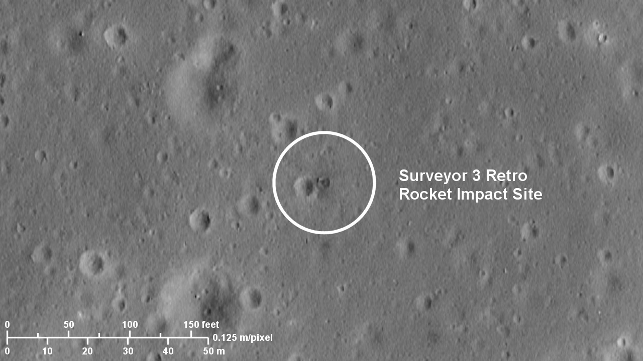
On another note, I can 100% confirm your discovery of the Surveyor 3 Retro Rocket Impact Site. Further below I show a Quickmap link for the impact site, and "before" and "after" images of the Surveyor 3 retro rocket impact. Lunar Orbiter 3 photographed the Apollo 12 landing site and the Surveyor 3 landing site on February 20, 1967. Surveyor 3 landed on the moon four months later on April 20, 1967. LRO image M175428601 was taken on November 8, 2011.
Best regards,
GoneToPlaid
LRO Quickmap location of the Surveyor 3 retro rocket impact site:
Surveyor 3 Retro Rocket Impact Site
Lunar Orbiter III image 3154 H2:
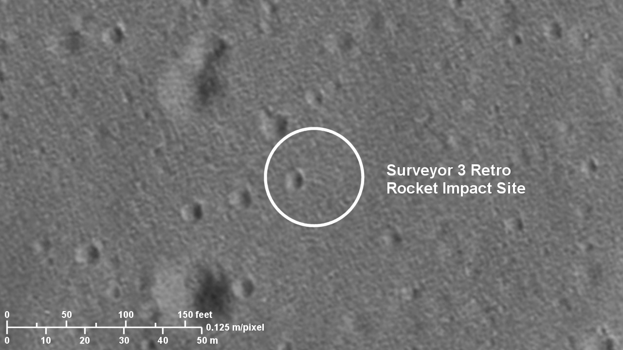
LRO image M175428601RC, deconvolved and enhanced:
Phil, your image reprojection experiment is very interesting indeed!
On another note, I can 100% confirm your discovery of the Surveyor 3 Retro Rocket Impact Site. Further below I show a Quickmap link for the impact site, and "before" and "after" images of the Surveyor 3 retro rocket impact. Lunar Orbiter 3 photographed the Apollo 12 landing site and the Surveyor 3 landing site on February 20, 1967. Surveyor 3 landed on the moon four months later on April 20, 1967. LRO image M175428601 was taken on November 8, 2011.
Best regards,
GoneToPlaid
LRO Quickmap location of the Surveyor 3 retro rocket impact site:
Surveyor 3 Retro Rocket Impact Site
Lunar Orbiter III image 3154 H2:
LRO image M175428601RC, deconvolved and enhanced:
QUOTE (Phil Stooke @ Feb 21 2017, 03:43 PM)
That has to be one of the most puzzling things I have ever seen on the Moon...
Click to view attachment
Click to view attachment
Neat. What's the scale on these? It is interesting that the top and bottom object seem to both be about the same height, based particularly upon the shadows in the bottom left image. Also, both seem to have a sort of "shelf" projecting from their base, projecting above (in the image direction) the top one and below the bottom one. It is almost like they were once part of the same structure.
One thought -- perhaps this was once part of a layer of basalt overlaying loose regolith, subsequently blown apart and tilted on-edge by a later impact? If so, an argument might be made that the flatter side of each object -- closer to the center of the images -- may have been on the surface at one time, when the liquid magma formed an equipotential surface, with the opposite side being a cast of what was previously textured regolith. Maybe a close-up image would reveal casts of small craters in the regolith cast.
QUOTE (Phil Stooke @ Apr 2 2017, 02:25 PM)
superimposed on top of it are Apollo 12 panoramic images
Ooo - later missions that did Standup EVAs might be good for this!
Doug
Good point, Doug. Only Apollo 15 did a stand-up EVA, however. I'm looking at Apollo 11 right now, and adding a grid and hardware items to the Apollo 12 map. This is for the revised lunar exploration atlas.
Phil
Phil
QUOTE (Phil Stooke @ Apr 4 2017, 09:44 AM)
Good point, Doug. Only Apollo 15 did a stand-up EVA, however. I'm looking at Apollo 11 right now, and adding a grid and hardware items to the Apollo 12 map. This is for the revised lunar exploration atlas.
Phil
Phil
Hi Phil,
You might want my deconvolved and enhanced LRO low periapse image of the A12 landing site. The image is 9206 x 12000 pixels with an image scale is 0.125 meters per pixel. Similarly, you might want my deconvolved and enhance LRO low periapse image for the A11 landing site. The A11 image includes the approach path to the landing site such that reprojected DAC images could be overlaid. The DAC footage, once the LM was lower than 500 feet as the LM overflew the north side of West Crater, has better resolution than the deconvolved LRO image. My deconvolved LRO image is 18962 x 17838 pixels with an image scale of 0.125 meters per pixel.
Best regards,
--Michael
Thanks, Michael - I have seen your images at the Apollo Lunar Surface Journal (in case any UMSF fans are not familiar with it, it is an unequaled source of information on all Apollo lunar surface activities)
At the scale these maps will be reproduced the highest resolution is not really necessary. But thanks anyway. The Lunar Orbiter image you posted is sharper than any I have seen. Is it from LOIRP?
A similar before and after pair can be made at the Surveyor 6 site where we also have an LO image - I think it's posted above in this thread, but not as clearly as you could show it.
Phil
QUOTE (algorimancer @ Apr 4 2017, 09:18 AM)
Neat. What's the scale on these? It is interesting that the top and bottom object seem to both be about the same height, based particularly upon the shadows in the bottom left image. Also, both seem to have a sort of "shelf" projecting from their base, projecting above (in the image direction) the top one and below the bottom one. It is almost like they were once part of the same structure.
One thought -- perhaps this was once part of a layer of basalt overlaying loose regolith, subsequently blown apart and tilted on-edge by a later impact? If so, an argument might be made that the flatter side of each object -- closer to the center of the images -- may have been on the surface at one time, when the liquid magma formed an equipotential surface, with the opposite side being a cast of what was previously textured regolith. Maybe a close-up image would reveal casts of small craters in the regolith cast.
One thought -- perhaps this was once part of a layer of basalt overlaying loose regolith, subsequently blown apart and tilted on-edge by a later impact? If so, an argument might be made that the flatter side of each object -- closer to the center of the images -- may have been on the surface at one time, when the liquid magma formed an equipotential surface, with the opposite side being a cast of what was previously textured regolith. Maybe a close-up image would reveal casts of small craters in the regolith cast.
I have been studying Ina and other lunar IMPs (Irregular Mare Patches) for the past couple of years. I looked at these blocks, and then I looked at what I see very close by and what I see in the general surrounding region further away. I see volcanic vents very close by these blocks, and I see volcanic vents and similar terrain further away from these blocks. In a nutshell, it appears that upwelling lava melted the overlying crust and regolith and then receded back down the vents. The result is that these blocks of very old lunar crust were exposed by the lava which then receded back down the nearby vents. Analysis of the slopes of the nearby terrain would appear to support this conclusion since the vents are located "downhill". Looking carefully at the blocks, one sees downslope erosion on the blocks with accumulations near the bottoms of the blocks. This erosion is the result of aeons of micrometeorite bombardment. Additionally, visual analysis of the density of small cratering which is seen indicates that this particular feature is much older than the freshest features which are seen at Ina and which are generally seen at most of the IMPs. Whereas everything screams at me that the youngest features which are seen within the Ina volcanic caldera are less than 65 million years old (younger than the extinction of the dinosaurs), these blocks and terrain appear to be much older features. My rough estimate is that these blocks and the surrounding vents may be up to one billion years old. Again, this is just a rough estimate.
Kudos to James Fincannon for locating and asking questions about this rather interesting lunar feature. If we can find more similar features on the moon which clearly are much older than the present list of IMPs, then we could create a whole new category of such much older IMPs. I propose calling them GYIMPs (GigaYear Irregular Mare Patches). This would be right up Phil's alley of expertise in terms of writing research papers about them. By the way, IMPs are called Irregular Mare Patches since they are mostly found on the lunar maria. Yet James Fincannon's discovery clearly is not on a lunar mare. This makes his discovery even more interesting.
QUOTE (Phil Stooke @ Apr 4 2017, 03:54 PM)
Thanks, Michael - I have seen your images at the Apollo Lunar Surface Journal (in case any UMSF fans are not familiar with it, it is an unequaled source of information on all Apollo lunar surface activities)
At the scale these maps will be reproduced the highest resolution is not really necessary. But thanks anyway. The Lunar Orbiter image you posted is sharper than any I have seen. Is it from LOIRP?
A similar before and after pair can be made at the Surveyor 6 site where we also have an LO image - I think it's posted above in this thread, but not as clearly as you could show it.
Phil
At the scale these maps will be reproduced the highest resolution is not really necessary. But thanks anyway. The Lunar Orbiter image you posted is sharper than any I have seen. Is it from LOIRP?
A similar before and after pair can be made at the Surveyor 6 site where we also have an LO image - I think it's posted above in this thread, but not as clearly as you could show it.
Phil
Hi Phil,
I retrieved the LO image from the USGS Lunar Orbiter PDS image archive which is continuously being updated by the LOIRP team to the USGS repository. I would like to visit the LOIRP team's former McDonald's location where they have been doing all of their work. It would be a riot of fun to see how they do it! You might notice that the Lunar Orbiter close-up image which I posted (after reprocessing it and reprojecting it to match the image scale of my deconvolved and enhanced LRO image) clearly shows small scale image streaking and mottling artifacts. These artifacts are in the original image. It appears that these artifacts perhaps were created by either anisotropic or wavelet filtering algorithms which may have been used by the LOIRP team to "denoise" the film grain. If so, then their filter settings were too strong (as in too spatially broad). On the other hand, I suppose that it is possible that these streaking and mottling artifacts could have been created by the Lunar Orbiter's analog film scanning, signal transmission, and signal reception systems since pure analog systems, unlike digital systems, can behave "quite weirdly" at their limits. I also have to factor in the fact that all optical systems, including the optical system which scanned the LO developed film, are in fact simply other analog systems.
By the way, the terrain did not prevent the A12 astronauts from seeing the Surveyor 3 retro rocket impact location. This is based on a LRO DTM of the terrain. The Apollo 12 EVA photograph AS12-46-6759 may show the impact crater and "something" a bit in the foreground. I will have to deconvolve this image, and possibly the adjacent images, in order to "see what we can see". These EVA images were clearly taken with the Hasselblad camera lens set at the "medium" lens paddle focus distance instead of the infinity focus distance.
What I need to know is just what a Surveyor's jettisoned retro rocket looks like.
Best regards,
--Michael
QUOTE (GoneToPlaid @ Apr 5 2017, 03:37 AM)
What I need to know is just what a Surveyor's jettisoned retro rocket looks like.
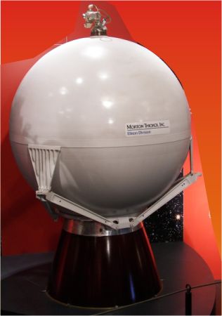
...but rather more battered.
This is my interpretation of the field of view of the Apollo image AS12-46-6759. First a rough perspective view of the image to help identify features near the horizon.
Click to view attachment
And a broader LROC view of the area:
Click to view attachment
The prominent crater with a little crater on its near rim (A) is not the larger one near the retro-rocket impact - B. If B is visible at all it is the one barely visible near the right edge and horizon. I don't thing the retro-rocket casing would be visible at all, given the poor focus and the distance. In particular it's not the nice round object just beyond A.
Phil
Click to view attachment
And a broader LROC view of the area:
Click to view attachment
The prominent crater with a little crater on its near rim (A) is not the larger one near the retro-rocket impact - B. If B is visible at all it is the one barely visible near the right edge and horizon. I don't thing the retro-rocket casing would be visible at all, given the poor focus and the distance. In particular it's not the nice round object just beyond A.
Phil
QUOTE (GoneToPlaid @ Apr 5 2017, 02:20 AM)
Kudos to James Fincannon for locating and asking questions about this rather interesting lunar feature.
... Yet James Fincannon's discovery clearly is not on a lunar mare. This makes his discovery even more interesting.
... Yet James Fincannon's discovery clearly is not on a lunar mare. This makes his discovery even more interesting.
Hello GoneToPlaid! Good to hear from you!
Thanks for your desire to credit me with finding this peculiar feature, however, I must correct the record in that I merely heard about it on some podcast and then googled it to find that others have investigated it (Google pointe dme to someplace called the Lunascan project). I realized that the Unmanned Spaceflight forum has a high level of lunar expertise so was hoping to obtain some scientific conjecture on the blocks. I can say I was not disappointed.
However, even with the conjectures presented here so far (although they are interesting and educational), I still am not completely convinced due to the one-off nature of the blocks. This is like Tabby's Star in a way. If we could find others that are just like it, it would help a lot in explaining it definitively.
QUOTE (algorimancer @ Apr 4 2017, 06:18 PM)
Neat. What's the scale on these?
The length of the long object is 64 m. The shorter is 40 m. They are about 15 m wide
The impact crater caused by the Surveyor 3 retrorocket was fortuitously photographed during the Apollo 12 landing:
http://www.unmannedspaceflight.com/index.p...st&p=226887
http://www.unmannedspaceflight.com/index.p...st&p=226887
QUOTE (James Fincannon @ Apr 5 2017, 07:06 AM)
Hello GoneToPlaid! Good to hear from you!
Thanks for your desire to credit me with finding this peculiar feature, however, I must correct the record in that I merely heard about it on some podcast and then googled it to find that others have investigated it (Google pointe dme to someplace called the Lunascan project). I realized that the Unmanned Spaceflight forum has a high level of lunar expertise so was hoping to obtain some scientific conjecture on the blocks. I can say I was not disappointed.
However, even with the conjectures presented here so far (although they are interesting and educational), I still am not completely convinced due to the one-off nature of the blocks. This is like Tabby's Star in a way. If we could find others that are just like it, it would help a lot in explaining it definitively.
Hi James,
Actually, there is a similar feature which are seen in the crater Obama (adjacent to Ina), and which is seen at other IMPs. So your identified feature is not a "one-off" feature which is seen on the moon.
Best regards,
--GoneToPlaid
QUOTE (GoneToPlaid @ Apr 5 2017, 07:51 PM)
Hi James,
Actually, there is a similar feature which are seen in the crater Obama (adjacent to Ina), and which is seen at other IMPs. So your identified feature is not a "one-off" feature which is seen on the moon.
Best regards,
--GoneToPlaid
Actually, there is a similar feature which are seen in the crater Obama (adjacent to Ina), and which is seen at other IMPs. So your identified feature is not a "one-off" feature which is seen on the moon.
Best regards,
--GoneToPlaid
Hello GoneToPlaid,
You mean Crater Osama (not Obama
 right? http://bit.ly/2o4h6QA
There are lots of places on the Moon that have obvious boulders or rocks that are shed (and I really think Ina features are great, by the way!). But the problem is that they are obvious. Same for the boulder tracks. You can see that the boulders rolled from the top of the crater to the floor, regardless of whether they bounced, skipped, slid, wobbled or just plain rolled.
What I would like to see is more such blocks with no apparent origin. Something like this http://bit.ly/2o4osUg in Crater Vertregt K, although it is not quire "there" yet.
QUOTE (James Fincannon @ Apr 5 2017, 12:37 PM)
Hello GoneToPlaid,
You mean Crater Osama (not Obama right? http://bit.ly/2o4h6QA
There are lots of places on the Moon that have obvious boulders or rocks that are shed (and I really think Ina features are great, by the way!). But the problem is that they are obvious. Same for the boulder tracks. You can see that the boulders rolled from the top of the crater to the floor, regardless of whether they bounced, skipped, slid, wobbled or just plain rolled.
What I would like to see is more such blocks with no apparent origin. Something like this http://bit.ly/2o4osUg in Crater Vertregt K, although it is not quire "there" yet.
You mean Crater Osama (not Obama
right? http://bit.ly/2o4h6QAThere are lots of places on the Moon that have obvious boulders or rocks that are shed (and I really think Ina features are great, by the way!). But the problem is that they are obvious. Same for the boulder tracks. You can see that the boulders rolled from the top of the crater to the floor, regardless of whether they bounced, skipped, slid, wobbled or just plain rolled.
What I would like to see is more such blocks with no apparent origin. Something like this http://bit.ly/2o4osUg in Crater Vertregt K, although it is not quire "there" yet.
Oops! Yes, I meant to say Osama.
Hi James - you did that amazing work a while ago (2011) on showing that most of the Apollo flags were still upright. In particular, at Apollo 14, you had noted in 2012 that its shadow could not be seen:
https://www.hq.nasa.gov/alsj/a14/a14FlagDeployment.html
I wondered if you had revisited the LROC images since then, since we have more views now.
I just looked at a sequence of images and I see that the Apollo 14 flag shadow is in fact clearly visible. With hindsight I can now see it in your sequence at that link.
Here's a set of stills with the flag and MET shadows indicated.
Phil
Click to view attachment
Can I just say how fantastic it is to be able to see if the flags are still up at the Apollo landing sites? Thank you LRO! Thank you, picture processors, for picking out the shadows of the flags!
What does this mean for the hardiness of the flag materials? I seem to remember they were likely to disintegrate by now.
bob
What does this mean for the hardiness of the flag materials? I seem to remember they were likely to disintegrate by now.
bob
Some people have suggested the flags would have disintegrated under solar UV and other environmental factors. I think the current view is that the degradation observed on Earth is accelerated by the presence of oxygen in the air, and it seems the flags are mostly intact on the Moon at present.
Phil
Phil
I read somewhere that the colours would gradually be lost, due to the radiation, and they'd have lost their patterns and turned white by now? I suppose that's more of a material chemistry question; the only way to find out for sure is a followup landing...
QUOTE (Phil Stooke @ Apr 8 2017, 03:26 PM)
Some people have suggested the flags would have disintegrated under solar UV and other environmental factors. I think the current view is that the degradation observed on Earth is accelerated by the presence of oxygen in the air, and it seems the flags are mostly intact on the Moon at present.
"We" may have established that view 7 1/2 years ago in this thread.
Post 87 links to an Air & Space article where the flag's manufacturer concludes that a 39 year-old nylon flag on earth would be in rough shape, certainly the ones on the moon were "dust" or "bleached" as suggested by the article's author. Mcaplinger was immediately skeptical.
Then around post 322 the topic came up again and some armchair chemist named stevesliva appealed to the authority of http://en.wikipedia.org/wiki/UV_degradation ...
So yeah, grain of salt either way. They certainly appear to be there, still!
QUOTE (Explorer1 @ Apr 8 2017, 04:57 PM)
I read somewhere that the colours would gradually be lost, due to the radiation, and they'd have lost their patterns and turned white by now? I suppose that's more of a material chemistry question; the only way to find out for sure is a followup landing...
All of the flags (except for Apollo 11 which was blown down on LM liftoff) are casting very dark shadows. One might assume that even if most of the colors have faded away, the flags could still cast dark shadows with mid morning or mid afternoon sunlight at the landing sites. Yet interestingly, all of the flags cast very dark shadows even with the sun very low above the east or west horizon in which the sunlight is striking the flags as face-on as possible. This seems to imply that the flags are still quite opaque. For example, the A12 flag's shadow at sunrise or sunset is noticeably darker than the high gain antenna shadow, yet not as dark as the LM descent stage shadow.
QUOTE (Phil Stooke @ Apr 8 2017, 06:58 PM)
Hi James - you did that amazing work a while ago (2011) on showing that most of the Apollo flags were still upright. In particular, at Apollo 14, you had noted in 2012 that its shadow could not be seen:
https://www.hq.nasa.gov/alsj/a14/a14FlagDeployment.html
I wondered if you had revisited the LROC images since then, since we have more views now.
I just looked at a sequence of images and I see that the Apollo 14 flag shadow is in fact clearly visible. With hindsight I can now see it in your sequence at that link.
I do not understand how you can see it is "clearly visible". For one thing, do we know where the antenna is? Is it on its side to cast a thick shadow or what?
I would need to calculate the length of the flag shadow (not including the pole) for the shallowest sun elevation images to confirm this is likely a flag shadow. It did not jump out at me at the time as being obvious, but maybe I was wrong.
I didn't mention the antenna, but this is my interpretation of what we see:
Click to view attachment
In the sequence I posted, let me point out the 4th frame down which, uniquely among them, shows a bright linear glint. I interpret it as a reflection off one of the antenna legs, which in one frame is perfectly placed to give a strong reflection. We see similar things with ALSEP cables etc, showing bright in the occasional image and not in others.
But we know where the flag was placed and we see it relative to the MET in images from the LM window. Its shadow would be very slightly north of the MET shadow. In my sequence it clearly progresses with the lighting just like all the other shadows. And your sequence from the ALSJ page has it faintly visible as well.
Of course, you are right, its geometry should be calculated.
In my site map I show a 'dark spot'. I am having trouble figuring out what it is. We have good images of the area from the LM window and nothing obvious shows up.
Phil
Hi everyone,
The LRO Team has posted sunrise to sunset "flip books", using actual LRO images, for each of the landing sites. They got the idea from one of my YouTube videos (no longer available since I closed that particular YT account) in which I animated LRO images of the Apollo 11 landing site to show the landing site from lunar sunrise to sunset. You all can check out the LRO Team's landing site sunrise to sunset flip books for each landing site here:
http://lroc.sese.asu.edu/featured_sites#ApolloLandingSites
It is a riot of fun to slide the slider back and forth to see all of the shadows of the Apollo mission artifacts, including the flag shadows move back and forth. Just as interesting is to see the glints off of some objects such as the LM footpads and lunar experiments which become strongly visible for given combinations of solar incidence and emission angles, yet which are not readily visible at other combinations of solar incidence and emission angles. The solar incidence angle is the elevation of the sun, relative to the zenith in the image, at the time when a given LRO image was acquired. Similarly, the solar emission angle is the angle towards the LRO camera, relative to the zenith in the image. You will see glints off of artifacts which do not correspond to any of the Apollo hardware, including the known locations of discarded covers and parts and tools. You might wonder what is the source of these extremely strong yet virtually pinpoint glints. These glints are from Kapton film which was blown off of the LM descent stages during the first second or two when each LM ascent stage lifted off from the lunar surface.
Finally, note that the LRO Team has resampled each image to an image scale of 0.5 meters which is the LRO Narrow Angle (NAC) camera's designed and theoretical resolution for the mission's Science phase orbital altitude of 50km. I normally present my deconvolved and enhanced LRO images at an image scale of 0.25 meters since under ideal conditions, very high contrast objects relative to the surrounding lunar terrain can be deconvolved to a lower limiting resolution. During the LRO's Science and Extended Mission phases, the LRO did for periods of time alter its orbit into low and very low periapse orbits in order to obtain higher resolution images of the Apollo landing sites. These orbits were highly unstable and could only be done for limited periods of time. After image deconvolution of images which were obtained during these lower LRO orbital altitudes, I generally present these images at an image scale of 0.125 meters, and sometimes at even smaller image scales, as shown below.
Below is the LRO Team's very low periapse image of the Apollo 11 landing site (left) versus my deconvolved and enhanced version (right) of the same image. The LRO'a orbital altitude was 24km. The image is M175124932R which was taken on 2011-11-05 (UT with Y-M-D nomenclature):
Click to view attachment
Best regards to all,
--GTP
QUOTE (gwiz @ Apr 5 2017, 02:51 AM)
...but rather more battered.
How big is the retro rocket?
QUOTE (GoneToPlaid @ Apr 19 2017, 04:23 PM)
How big is the retro rocket?
my sources say a sphere 94 cm (3 ft) across
QUOTE (GoneToPlaid @ Apr 19 2017, 07:23 AM)
How big is the retro rocket?
I'm pretty sure Surveyor used an early version of the Star-37 -- http://www.astronautix.com/s/star37.html -- so 0.66 meters in diameter.
QUOTE (Phil Stooke @ Apr 5 2017, 06:18 AM)
This is my interpretation of the field of view of the Apollo image AS12-46-6759. First a rough perspective view of the image to help identify features near the horizon.
Click to view attachment
And a broader LROC view of the area:
Click to view attachment
The prominent crater with a little crater on its near rim (A) is not the larger one near the retro-rocket impact - B. If B is visible at all it is the one barely visible near the right edge and horizon. I don't thing the retro-rocket casing would be visible at all, given the poor focus and the distance. In particular it's not the nice round object just beyond A.
Phil
Click to view attachment
And a broader LROC view of the area:
Click to view attachment
The prominent crater with a little crater on its near rim (A) is not the larger one near the retro-rocket impact - B. If B is visible at all it is the one barely visible near the right edge and horizon. I don't thing the retro-rocket casing would be visible at all, given the poor focus and the distance. In particular it's not the nice round object just beyond A.
Phil
A in your reprojected view of AS12-46-6749 really is B as labeled in your LRO overhead view. The terrain towards the Surveyor III retro rocket impact site actually is somewhat up-slope from the landing site -- just a bit more than enough up-slope to counter the local curvature of the lunar surface when looking towards the retro rocket impact site from near the lunar module. Although you postulated that the retro rocket might be resting on the lip of its created crater, to me and in my deconvolved images the retro rocket appears to be resting at the center of the crater. The nozzle is perhaps casting a very fine yet distinct shadow within the crater. The lip on the crater appears to be just that -- a crater lip and not the retro rocket itself.
AS12-46-6738 also appears to show the Surveyor III retro rocket impact site. I will post enhanced photos of this particular image.
It's very difficult to match points between surface and overhead views, and I have certainly made many mistakes in the past. That's why I like to stretch out the image in a reprojection. But in this case I think my matching features were correct.
Here is a direct comparison between the roughly projected view and a greatly enlarged LROC NAC image (M162466771L). Over 20 points of correspondence can be mapped. Number 15 is my previous crater A. Out at the edge, beyond my points 14 and 21, the surface drops into a shallow crater, and my previous crater B is seen where its far rim rises up again, twice as far away, but still short of the retro-rocket.
Phil
Click to view attachment
QUOTE (Phil Stooke @ Apr 19 2017, 11:34 AM)
It's very difficult to match points between surface and overhead views, and I have certainly made many mistakes in the past. That's why I like to stretch out the image in a reprojection. But in this case I think my matching features were correct.
Here is a direct comparison between the roughly projected view and a greatly enlarged LROC NAC image (M162466771L). Over 20 points of correspondence can be mapped. Number 15 is my previous crater A. Out at the edge, beyond my points 14 and 21, the surface drops into a shallow crater, and my previous crater B is seen where its far rim rises up again, twice as far away, but still short of the retro-rocket.
Phil
Click to view attachment
Here is a direct comparison between the roughly projected view and a greatly enlarged LROC NAC image (M162466771L). Over 20 points of correspondence can be mapped. Number 15 is my previous crater A. Out at the edge, beyond my points 14 and 21, the surface drops into a shallow crater, and my previous crater B is seen where its far rim rises up again, twice as far away, but still short of the retro-rocket.
Phil
Click to view attachment
That matching is spot on!
QUOTE (James Fincannon @ Apr 10 2017, 05:42 PM)
I do not understand how you can see it is "clearly visible". For one thing, do we know where the antenna is? Is it on its side to cast a thick shadow or what?
I would need to calculate the length of the flag shadow (not including the pole) for the shallowest sun elevation images to confirm this is likely a flag shadow. It did not jump out at me at the time as being obvious, but maybe I was wrong.
I would need to calculate the length of the flag shadow (not including the pole) for the shallowest sun elevation images to confirm this is likely a flag shadow. It did not jump out at me at the time as being obvious, but maybe I was wrong.
In the Flip Book (which is indeed an excellent and fun way to analyse the terrain and Apollo stuff on the ground), around the 9:00 to 11:00 time marks, I can see the flag's shadow clearly. It appears to be detached from the ground, which is what a flag's shadow does because it's on a pole, at some elevation from the ground:
Click to view attachment
A darkish area appears on the image at around 8:20 time mark, indicated here in an enhanced image:
Click to view attachment
I believe this is the actual location of the flag, showing the disturbed lunar soil:
Click to view attachment
The antenna doesn't really cast much of a shadow, it looks very pale in LROC images:
Click to view attachment
Click to view attachment
And MET's shadow stays attached to it, as it's sitting directly on the ground. It is visible earlier in the morning (if you move the slider from right to left), before the flag's shadow becomes clearly visible.
QUOTE (Phil Stooke @ Apr 10 2017, 06:01 PM)
In my site map I show a 'dark spot'. I am having trouble figuring out what it is. We have good images of the area from the LM window and nothing obvious shows up.
Phil
Phil
I have overlayed your schematic over a couple of LROC images at different sun angles (only your arrows, etc. remain, the background is now from different images).
The first one, where a PLSS is clearly visible:
Click to view attachment
It looks like the dark spot is just a subtle part of landscape, either some soil that was kicked up by the PLSS, or just a quirk of terrain (it's inside a very shallow crater)
Here's a second image, where that area is more directly illuminated by the rising Sun:
Click to view attachment
Nice images! The dark spot puzzles me because it doesn't seem to move with changing sun height, so it is on the surface, but there is absolutely nothing there in the images from the LM window after EVA 2. I have wondered if it was a bit of material thrown there during the LM liftoff, though usually when we see that it is bright, not dark (e.g around Apollo 11 in LRO images).
Phil
Phil
QUOTE (Phil Stooke @ May 3 2017, 02:53 AM)
Nice images! The dark spot puzzles me because it doesn't seem to move with changing sun height, so it is on the surface, but there is absolutely nothing there in the images from the LM window after EVA 2. I have wondered if it was a bit of material thrown there during the LM liftoff, though usually when we see that it is bright, not dark (e.g around Apollo 11 in LRO images).
Phil
Phil
The "dark spot" only shows up clearly in high sun angle NAC images, suggesting that it's simly rougher soil that doesn't reflect as much sunlight directly upwards as the surrounding area (same as with astronauts' foot tracks and other disturbed soil areas (however, the roughness in this case might be completely natural)). This roughness and the effect it produces wouldn't be obvious from a shallow-angle Apollo photo from the LM.
These are all just my musings, of course, based on what I see in the images.
These are two Apollo 14 images taken from the LM windows:
Pre-EVA 1:
https://www.hq.nasa.gov/alsj/a14/AS14-65-9204HR.jpg (lower left corner)
Post-EVA 2:
https://www.hq.nasa.gov/alsj/a14/AS14-66-9338HR.jpg (left of centre, just beyond the flag shadow)
I just find it surprising that there is not something more obvious at that location. A little crater might contribute a bit, but it's very small. I mentioned the possibility of a bit of LM descent stage material blown off by the ascent stage during launch, and it occurs to me now that an item like that might have scuffed the surface before being blown further away, creating disturbed soil after the last surface image was taken.
Phil
I am mapping the Apollo traverses using tracks visible in LRO images where possible and matching photos taken from the LRV during the drive to LRO images when tracks are invisible. Here is the area around Hole in the Wall, Apollo 17 EVA 2, which is always misrepresented on published maps. It's a work in progress but it shows how the LRV approached the scarp, then Cernan saw an obstacle (a pit) in the mouth of the gap, turned sharply to the southeast, then back and up the slope to the left (south) of a crater. This matches the transcript on the Apollo Lunar Surface Journal at that point. All published maps that I am aware of show the rover head straight for a steep part of the scarp a bit further south and up and over it. I am making plans to publish all this work eventually. This of course is just the rough working map, but I thought some people might find it interesting.
Phil
Click to view attachment
Phil
Click to view attachment
Great to have that one finally resolved, Phil.
We had often thought that the post-mission traverse maps were wrong.
Many thanks!
We had often thought that the post-mission traverse maps were wrong.
Many thanks!
It amazes me how you are able to ID the LRV photography locations. I looked at a few on this part of EVA-2, and I can only agree with your positioning. How do you do that?
Can't wait to see the completed work.
Can't wait to see the completed work.
Very nice! Looks like there's one typo on the map- the highest-numbered location should be 21137, not 22137.
It was fun hearing Harrison Schmitt himself talk about Shorty Crater at LPSC last week. Also at LPSC, Carter Emmart had a cool VR exhibit incorporating Apollo 17 surface photography, including some of the large boulders, into a VR environment, allowing you to get up close and check out the rock textures.
John
There's always a typo! There was one on my poster.
This is what I do to help locate these images. I do a partial reprojection - not meant to be accurate, but enough to make the image easier to compare with the LRO image. Plus a contrast enhancement if necessary, as it usually is. This one is south of Hole in the Wall. I have done it for almost every image taken from the rover, but I haven't actually located every one.... All this work will be on the Apollo Lunar Surface Journal for all 3 rover missions, as well as whatever I may have planned for publication.
Schmitt on Shorty: There is a subdued crater a bit bigger than Shorty and abutting it on the south, never named before, but at LPSC he called it 'Fitzgibbon'. He said there was a story behind it, but he didn't tell it. The crater is significant because samples suggested an exposure age of 17 M years and he thought Shorty should be younger than that. Now he has an age for Shorty of 3 M years, so he thought the 17 M years age was for 'Fitzgibbon'.
But here's the meaning of that name. Jack Schmitt's wife's family name was Fitzgibbon. At a meeting last year he said he had to name a crater after her because she was looking over his shoulder as he prepared that presentation. I think he was talking about a different crater last year than he mentioned this year, up near the scarp. Always the joker, our Harrison.
Phil
Click to view attachment
This is a "lo-fi" version of our main content. To view the full version with more information, formatting and images, please click here.