Radar And Mariner 10, Best possible mapping, pre-Messenger |

  |
Radar And Mariner 10, Best possible mapping, pre-Messenger |
 Apr 28 2005, 06:21 PM Apr 28 2005, 06:21 PM
Post
#1
|
|
 Senior Member  Group: Members Posts: 2530 Joined: 20-April 05 Member No.: 321 |
[...]
|
 |
 
|
|
May 11 2005, 12:20 AM
Post
#2
|
|
|
Senior Member Group: Members Posts: 1276 Joined: 25-November 04 Member No.: 114 |
|
|
|
|
|
May 11 2005, 12:25 AM
Post
#3
|
|
|
Senior Member Group: Members Posts: 1276 Joined: 25-November 04 Member No.: 114 |
|
|
|
|
|
May 11 2005, 01:48 AM
Post
#4
|
|
 Senior Member Group: Members Posts: 1281 Joined: 18-December 04 From: San Diego, CA Member No.: 124 |
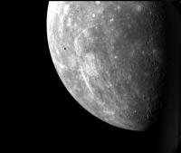
QUOTE (Decepticon @ May 10 2005, 04:25 PM) http://www.psrd.hawaii.edu/WebImg/HarmonRadarFig2.jpg Awesome! Love the possiblity of ice in the polar craters - http://images.google.ca/imgres?imgurl=http...2005-12,GGLD:en  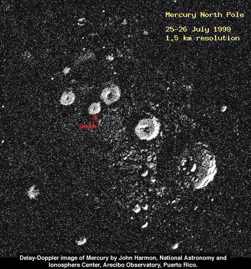 I guess it's only fitting to have water on Mercury, if we have mercury in our water here.... 
-------------------- Lyford Rome
"Zis is not nuts, zis is super-nuts!" Mathematician Richard Courant on viewing an Orion test |
|
|
|
|
May 11 2005, 04:47 PM
Post
#5
|
|
|
Senior Member Group: Members Posts: 2530 Joined: 20-April 05 Member No.: 321 |
[...]
|
|
|
|
|
May 11 2005, 07:18 PM
Post
#6
|
|
 Interplanetary Dumpster Diver Group: Admin Posts: 4404 Joined: 17-February 04 From: Powell, TN Member No.: 33 |
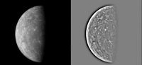
(Added detail: One of the major methodologies in high-resolution radar mapping produces an image which reflects details over a line which is near the equator, so the result is not a flawless hemispheric image, but an image which shows the north and south hemispheres ambiguously overlapped, so that you can say with confidence that each feature so detected is either in the northern OR southern hemisphere, but you can't be sure which! This ambiguity can be eliminated with repeat observations, with slightly changed geometry, which will cause the overlapping to happen at a different angle, revealing which hemisphere a feature is really in. I'm not sure if this final step has yet been performed, but the conference abstracts describing the work do not mention the ambiguity problem.)
I imagine that optical data could help - in other words, if there is a bright feature with rays extending from it in one hemisphere, and there is clearly a well defined, young looking (not overlapped by anything) impact crater in one hemisphere or the other, the optical data could help resolve the situation. -------------------- |
|
|
|
|
May 11 2005, 09:34 PM
Post
#7
|
|
|
Senior Member Group: Members Posts: 2530 Joined: 20-April 05 Member No.: 321 |
[...]
|
|
|
|
|
May 14 2005, 04:51 PM
Post
#8
|
|
|
Solar System Cartographer Group: Members Posts: 10169 Joined: 5-April 05 From: Canada Member No.: 227 |
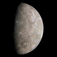
I too am interested in this topic of pre-Messenger mapping of Mercury, in one of my many guises, as a historian of planetary cartography. One interesting aspect of cartographic history is the progression of mapping of a world from mission to mission... from pre-mission planning maps to the initial post-mission maps to assist initial data analysis, to the most advanced maps which summarize mission results, including relief, topography where appropriate, and geological maps. Mariner 10 didn't use a pre-mission map in the sense that Mars missions did, but there was a preliminary post-mission 1:25,000,000 scale map, and then the set of 1:5,000,000 scale quads and a new 1:15,000,000 global map. (and a lot more outside this very basic framework, such as the unpublished global map showing only the first encounter results).
Yes, I'd love to see a good pre-mission map. You are right, JRehling, it could be done. I'd love to see your work on this, actually. But one problem is that the radar data are almost always treated as traditional astronomical data, belonging to the scientists who obtained them, not as typical planetary data which are made public (almost immediately these days in some cases, and in compressed form). We planet types are spoiled! But the radar people have never released things very readily, one exception being the "pre-Magellan" CD-ROM with some venus and lunar radar data. An awful lot of radar data never even gets adequately published either. Could your maps go up on a free image hosting service, with a URL in a post here? Phil -------------------- ... because the Solar System ain't gonna map itself.
Also to be found posting similar content on https://mastodon.social/@PhilStooke Maps for download (free PD: https://upload.wikimedia.org/wikipedia/comm...Cartography.pdf NOTE: everything created by me which I post on UMSF is considered to be in the public domain (NOT CC, public domain) |
|
|
|
|
May 16 2005, 12:04 AM
Post
#9
|
|
|
Senior Member Group: Members Posts: 2530 Joined: 20-April 05 Member No.: 321 |
[...]
|
|
|
|
|
May 16 2005, 12:50 PM
Post
#10
|
|
 Senior Member Group: Members Posts: 2488 Joined: 17-April 05 From: Glasgow, Scotland, UK Member No.: 239 |
The mercury maps are astonishing at this stage in the game! Terrific effort!
Can you post the link to the 8" amateur images? -------------------- Remember: Time Flies like the wind - but Fruit Flies like bananas!
|
|
|
|
|
May 16 2005, 08:45 PM
Post
#11
|
|
|
Senior Member Group: Members Posts: 2530 Joined: 20-April 05 Member No.: 321 |
[...]
|
|
|
|
|
May 16 2005, 09:11 PM
Post
#12
|
|
|
Senior Member Group: Members Posts: 2488 Joined: 17-April 05 From: Glasgow, Scotland, UK Member No.: 239 |
Thanks!
-------------------- Remember: Time Flies like the wind - but Fruit Flies like bananas!
|
|
|
|
|
May 17 2005, 04:43 PM
Post
#13
|
|
 Member Group: Members Posts: 154 Joined: 17-March 05 Member No.: 206 |
These are great images obtained from the ground. However, why couldn't the Hubble Space Telescope be used to image the non-Mariner side of Mercury? Hubble has resolved details on some of Juptier's moons (about the same size as Mercury) and Mercury is far closer to us.
|
|
|
|
|
May 17 2005, 04:53 PM
Post
#14
|
|
|
Senior Member Group: Members Posts: 1281 Joined: 18-December 04 From: San Diego, CA Member No.: 124 |
QUOTE (Chmee @ May 17 2005, 08:43 AM) These are great images obtained from the ground. However, why couldn't the Hubble Space Telescope be used to image the non-Mariner side of Mercury? Hubble has resolved details on some of Juptier's moons (about the same size as Mercury) and Mercury is far closer to us. Mercury is too close to the sun to be safely imaged by the Hubble. OUCH! -------------------- Lyford Rome
"Zis is not nuts, zis is super-nuts!" Mathematician Richard Courant on viewing an Orion test |
|
|
|
|
May 17 2005, 04:54 PM
Post
#15
|
|
|
Founder Group: Chairman Posts: 14432 Joined: 8-February 04 Member No.: 1 |
iirc - Hubble has a minimum sun angle which is can NOT go over - I dont think it's ever imaged Mercury simply because it's too close to the sun - and the damage that could be done is huge.
Doug |
|
|
|
|
May 17 2005, 05:27 PM
Post
#16
|
|
|
Member Group: Members Posts: 154 Joined: 17-March 05 Member No.: 206 |
I wonder if the concern is the actual damage if Hubble observed Mercury, or the potential damage if Hubble accidently pointed directly at the Sun as it slewed to obseve Mercury.
The difference is that if Hubble will not be saved and it will be de-orbited, might it be worth the risk to have it obseve Mercury as it's last obsevation? 
|
|
|
|
|
May 17 2005, 05:59 PM
Post
#17
|
|
|
Senior Member Group: Members Posts: 2530 Joined: 20-April 05 Member No.: 321 |
[...]
|
|
|
|
|
May 17 2005, 07:45 PM
Post
#18
|
|
|
Senior Member Group: Members Posts: 2488 Joined: 17-April 05 From: Glasgow, Scotland, UK Member No.: 239 |
A 'family portrait' of the Solar System by HST as it nears the end of it's operational lifetime would be very attractive, and a fitting companion to the Voyager 'Pale Blue Dot' sequence of images. Perhaps it could be justified as an engineering test, establishing a common baseline for all the available bodies it can see - not to mention a powerful bit of PR!
-------------------- Remember: Time Flies like the wind - but Fruit Flies like bananas!
|
|
|
|
|
Aug 15 2005, 03:26 PM
Post
#19
|
|
|
Member Group: Members Posts: 212 Joined: 19-July 05 Member No.: 442 |
Erwin Van Der Velden's home page has moved. His pictures can now be viewed at:
http://www.erwinvandervelden.id.au/ |
|
|
|
|
Aug 15 2005, 07:08 PM
Post
#20
|
|
|
Senior Member Group: Members Posts: 2488 Joined: 17-April 05 From: Glasgow, Scotland, UK Member No.: 239 |
QUOTE (gndonald @ Aug 15 2005, 04:26 PM) Erwin Van Der Velden's home page has moved. His pictures can now be viewed at: http://www.erwinvandervelden.id.au/ Wow! He's amazing - and with a C8! -------------------- Remember: Time Flies like the wind - but Fruit Flies like bananas!
|
|
|
|
|
Nov 15 2005, 07:17 PM
Post
#21
|
|
 Member Group: Members Posts: 710 Joined: 28-September 04 Member No.: 99 |
QUOTE (Bob Shaw @ Aug 15 2005, 07:08 PM) Wow! He's amazing - and with a C8! Sadly, he passed away recently: http://www.vereniging-astrofotografie.nl/n...en_english.html |
|
|
|
| Guest_DonPMitchell_* |
May 8 2006, 05:56 AM
Post
#22
|
|
Guests |
Here's one of Ksanfomality's new photos of Mercury.
[attachment=5491:attachment] |
|
|
|
|
May 20 2006, 05:04 AM
Post
#23
|
|
|
Member Group: Members Posts: 169 Joined: 17-March 06 Member No.: 709 |
I believe that 'Sky and Telescope' published a new mosaic of Mercury about 2 years ago, utilizing Mariner 10 images. It shows the entire hemisphere of Mercury imaged by Mariner 10 and was created by Mark Robinson of Northwestern, I believe. However, can any one find that image on the Internet? I'm sorry, but I do not recall which issue of 'Sky and Telescope' included that mosiac. Another Phil |
|
|
|
|
May 20 2006, 04:40 PM
Post
#24
|
|
|
Interplanetary Dumpster Diver Group: Admin Posts: 4404 Joined: 17-February 04 From: Powell, TN Member No.: 33 |
-------------------- |
|
|
|
|
May 21 2006, 09:09 AM
Post
#25
|
|
|
Senior Member Group: Members Posts: 1870 Joined: 20-February 05 Member No.: 174 |
When Mariner 10 did it's second flyby, as it was near closest approach, it stepped it's filter wheel on one <?> camera though a sequence of filters, specifically including one wide-angle frame using the fiber-optic link to the "parasitic" wide angle camera lens and took a single wide-angle full disk view of the planet.
That shot (almost never reproduced) remains the single best view of albedo patterns on a semi-full gibbous disk view of Mercury. It looks like a horribly blotched mouldy grapefruit. |
|
|
|
|
May 21 2006, 11:46 AM
Post
#26
|
|
|
Senior Member Group: Members Posts: 2488 Joined: 17-April 05 From: Glasgow, Scotland, UK Member No.: 239 |
QUOTE (edstrick @ May 21 2006, 10:09 AM) That shot (almost never reproduced) remains the single best view of albedo patterns on a semi-full gibbous disk view of Mercury. It looks like a horribly blotched mouldy grapefruit. OK, you've done the 'tell' bit, now how about the 'show' part of your presentation! Your classmates are waitingggggggg! Bob Shaw -------------------- Remember: Time Flies like the wind - but Fruit Flies like bananas!
|
|
|
|
| Guest_DonPMitchell_* |
May 21 2006, 03:06 PM
Post
#27
|
|
Guests |
QUOTE (PhilHorzempa @ May 19 2006, 10:04 PM) I believe that 'Sky and Telescope' published a new mosaic of Mercury about 2 years ago, utilizing Mariner 10 images. It shows the entire hemisphere of Mercury imaged by Mariner 10 and was created by Mark Robinson of Northwestern, I believe. However, can any one find that image on the Internet? I'm sorry, but I do not recall which issue of 'Sky and Telescope' included that mosiac. Another Phil Maybe Mattias Malmer will take an interst in this. I think he's one of the best at compositing spacecraft imaging. There's a thread about his work here, and here is his directory of work: Malmer Images. |
|
|
|
|
May 21 2006, 08:38 PM
Post
#28
|
|
 Member Group: Members Posts: 241 Joined: 22-August 05 From: Stockholm Sweden Member No.: 468 |
QUOTE (DonPMitchell @ May 21 2006, 05:06 PM) Maybe Mattias Malmer will take an interst in this. I think he's one of the best at compositing spacecraft imaging. There's a thread about his work here, and here is his directory of work: Malmer Images. That might be overstating things a little... but thank you very much  I make my living making 3D effects for commercials all day long... the ultimate in turdpolishing. So I can cheat my way into making pretty pictures from source that are less than optimal... I have been playing a little with the mariner 10 raw data and its actually pretty fantastic material. strange that we see so little of it displayed. The largest images of venus i have ever seen are in there. beautiful stuff. Mattias |
|
|
|
| Guest_DonPMitchell_* |
May 22 2006, 01:47 AM
Post
#29
|
|
Guests |
QUOTE (Malmer @ May 21 2006, 01:38 PM) That might be overstating things a little... but thank you very much I make my living making 3D effects for commercials all day long... the ultimate in turdpolishing. So I can cheat my way into making pretty pictures from source that are less than optimal... I have been playing a little with the mariner 10 raw data and its actually pretty fantastic material. strange that we see so little of it displayed. The largest images of venus i have ever seen are in there. beautiful stuff. Mattias Mariner-10 images are the best taken so far. Probably the height of vidicon tube technology before CCDs took over. There were a little over aggressive about bit rates, so the images are noisy, but some were sent at a reasonable rate. The Pioneer Venus camera (if you can call it a camera) was not so great, but there is sure a mountain of images from it...somewhere. They have never been put online. Let's hope Venus Express will be impressive. The VMC takes small pictures, but they are hoping to stitch together big panoramas. I'm sure over the next few years, the ESA will release a couple of them for us to see. :-) |
|
|
|
|
May 22 2006, 07:08 AM
Post
#30
|
|
 Senior Member Group: Members Posts: 3419 Joined: 9-February 04 From: Minneapolis, MN, USA Member No.: 15 |
You know, I got a book nearly 20 years ago that detailed the Mariner 10 mission, which included very nicely rendered airbrushed maps of the viewed portions of Mercury. It had a nice timeline in it which discussed events on Earth as they occurred during the Mariner 10 mission. (Unfortunately, the book was lost in a basement flood several years ago... *sigh*...)
It also had a very well-researched analysis of the Mariner 10 Mercury observations, including the terrain unit that you really don't see on the Moon -- the inter-crater plains. It seems very clear from the information wel already have about Mercury that the LHB didn't scar Mercury as badly as it scarred our own Moon. The population of large craters on Mercury is smaller than on the Moon, as witnessed by the fact that there are no places on the lunar surface where inter-crater plains still exist. On the Moon, the ancient crust has all been impacted at some point or another, with only a fairly minor exhibition of non-cratered mare surface here and there. The ancient crust of Mercury has been preserved without being marred by large cratering events in several places. I can't wait to see what Messenger finds when it arrives... -the other Doug -------------------- The trouble ain't that there is too many fools, but that the lightning ain't distributed right. -Mark Twain
|
|
|
|
|
May 22 2006, 08:45 AM
Post
#31
|
|
|
Senior Member Group: Members Posts: 1870 Joined: 20-February 05 Member No.: 174 |
Mariner 10 and Voyager had very similar camera systems. Selenium Sulfide vidicon tubes, who's design went back to Mariner 69 and maybe some Mariner Mars 64 heritage.
Mariner 4 had a horrendous light leak -- PAST the shutter mechanism -- and impossibly limited data storage. Mariners 6 and 7 tried to solve the data storage problem with a combined analog/digital dual recorder system that *SORT OF* worked but was compromized by tape-crud contamination buildup on the analog recorder heads. Mariner 9 upgraded to all digital, 9 bit (!) data and could stuff about 33 pics on a tape recorder load, doing 2 orbits a day and dumping 1 tape load just after a periapsis and the second just before the second periapsis (only one 210 foot DSN dish at the time). Unfortunately, the Mariner 69 and 71 data were badly corrupted by residual images. Approach images by Mariner 9 show multiple ghost imagtes of Mars in subsequent images in the sequence, slowly fading with each following shot. Mariner 10 (and Viking orbiters, and Voyagers) used brilliant (literally) brute force engineering to eliminate the residual image problem. After each frame, they turned lightbulbs on INSIDE the cameras, then erased the light-flood staturated image so each image had an essentially perfectly repeatable residual image after erasure. The noisy Mariner 10 data are from the Mercury flybys, where the range to Earth was right a the limit of the experimental 114,000 (or 148,000 or whatever then number was) bits / sec transmission rate. They traded off getting a LOT of salt-and-pepper speckled images at Mercury for fewer but clean images. The highest resolution images during the first flyby were tape recorded and played back later, the tape recorder failed before either the second (I think) or third flyby. DSN failure at the third flyby limited imaging to the central 1/4 or so of each frame due to a forced lower data rate, losing contiguous targeted high resolution mapping of selected targets <damn>. |
|
|
|
|
May 22 2006, 01:54 PM
Post
#32
|
|
|
Senior Member Group: Members Posts: 2488 Joined: 17-April 05 From: Glasgow, Scotland, UK Member No.: 239 |
oDoug:
Charles A Cross did an interesting mapping job on Mercury in the late 1970s - it'll be interesting to see if his work holds up. He published his maps (with Patrick Moore) but sadly then died. Update: Amazon have this book listed for £25 (there's a Mars volume too). Hardcover 48 pages (August 1977) Publisher: Mitchell Beazley ISBN: 0855331151 Bob Shaw -------------------- Remember: Time Flies like the wind - but Fruit Flies like bananas!
|
|
|
|
|
May 22 2006, 03:35 PM
Post
#33
|
|
|
Solar System Cartographer Group: Members Posts: 10169 Joined: 5-April 05 From: Canada Member No.: 227 |
Charles Cross did some interesting work. He let me copy some of his moon maps when I was a youngster just getting into the biz of planetary mapping many moons ago. - and he gave me a copy of the Mariner 6/7 map of Mars which is still one of my treasures. Then he did some Mariner 6/7 near-encounter mapping for the Rand Corporation, and then the Mercury and Mars atlases with Patrick Moore. Moore told me he had just completed Voyager mapping of the Galilean Satellites when he died. Those maps, which I would rent out an elderly relative to see, apparently disappeared into the archives of the BAA. Maybe somebody could find them...
Phil -------------------- ... because the Solar System ain't gonna map itself.
Also to be found posting similar content on https://mastodon.social/@PhilStooke Maps for download (free PD: https://upload.wikimedia.org/wikipedia/comm...Cartography.pdf NOTE: everything created by me which I post on UMSF is considered to be in the public domain (NOT CC, public domain) |
|
|
|
|
May 22 2006, 03:47 PM
Post
#34
|
|
|
Founder Group: Chairman Posts: 14432 Joined: 8-February 04 Member No.: 1 |
I am a BAA member - give me some specifics and I'll try and get to the BAA library next time I'm down with my laptop+scanner
Dorp me an email with the Info phil, and I'll see what I can do. Doug |
|
|
|
|
May 22 2006, 05:07 PM
Post
#35
|
|
|
Solar System Cartographer Group: Members Posts: 10169 Joined: 5-April 05 From: Canada Member No.: 227 |
I'm sorry, Doug, I don't know any more than that. Cross made maps of the four Galilean satellites just before he died, and they apparently ended up at the BAA. You would have to see if they have his papers there. I think the maps were made for another atlas with Patrick Moore, but then were not used. Possibly they were not finished enough. After that, the quality of mapping in Moore's atlases went seriously downhill. I expect it was handed over to some graphics contractors who knew nothing about the subject.
He did great work, one of the few amateur cartographers who really became involved in planetary exploration, with his work for Rand on Mariners 6 and 7. A commemorative website devoted to his work would be a really nice resource. Phil -------------------- ... because the Solar System ain't gonna map itself.
Also to be found posting similar content on https://mastodon.social/@PhilStooke Maps for download (free PD: https://upload.wikimedia.org/wikipedia/comm...Cartography.pdf NOTE: everything created by me which I post on UMSF is considered to be in the public domain (NOT CC, public domain) |
|
|
|
|
May 23 2006, 03:00 AM
Post
#36
|
||
|
Member Group: Members Posts: 169 Joined: 17-March 06 Member No.: 709 |
QUOTE (tedstryk @ May 20 2006, 12:40 PM) Thank you for this link. There is one mosaic, from the link above, from Mariner 10's second encounter with Mercury, that is close to what was in Sky and Telecope, namely this one.
However, as noted on the website, the gores in this image were to be filled in using images from the 1st and 3rd Mercury encounter. I believe that that was the mosiac that I saw in S and T. Does anyone have access to that image? I really liked it as it showed the entire hemisphere of Mercury, that was imaged by Mariner 10, in one view. Another Phil |
|
|
|
|
|
| Guest_DonPMitchell_* |
May 23 2006, 04:00 AM
Post
#37
|
|
Guests |
Do you have the ISIS calibration data for the Mariner-10 camera? Find the isisdist machine, where ever it is at the moment (the URL I used doesn't work now...welcome to NASA's churning domain names!). If you find it, look in isis/apps/mariner10. There are dark-current images, blemish maps and such.
Drop me an email if you want the FORTRAN code for linearizing the images. The calibration data is 260 MBytes, so try to find that online. |
|
|
|
|
May 27 2006, 05:06 AM
Post
#38
|
|
|
Member Group: Members Posts: 169 Joined: 17-March 06 Member No.: 709 |
QUOTE (Malmer @ May 21 2006, 04:38 PM) That might be overstating things a little... but thank you very much I make my living making 3D effects for commercials all day long... the ultimate in turdpolishing. So I can cheat my way into making pretty pictures from source that are less than optimal... I have been playing a little with the mariner 10 raw data and its actually pretty fantastic material. strange that we see so little of it displayed. The largest images of venus i have ever seen are in there. beautiful stuff. Mattias Here is the link to Malmer's "Big Io" image. It is truly one of the most beautiful space images that I have ever seen. I congratulate you on some excellent work. http://syndicate.se/image/space/io_big.jpg I do have a few questions. What is the source of the Io image? Did you process one Galileo image of Io or is this a mosaic? Also, do you know the date that the images were taken? Another Phil |
|
|
|
|
Dec 7 2006, 01:52 AM
Post
#39
|
|
|
Member Group: Members Posts: 315 Joined: 1-October 06 Member No.: 1206 |
Outstanding new Arecibo radar images of equatorial and mid latitudes discussed here:
http://www.sciencedirect.com/science?_ob=M...=/sdarticle.pdf P |
|
|
|
|
Dec 7 2006, 02:57 AM
Post
#40
|
|
|
Solar System Cartographer Group: Members Posts: 10169 Joined: 5-April 05 From: Canada Member No.: 227 |
Yes, that is an excellent article.
Phil -------------------- ... because the Solar System ain't gonna map itself.
Also to be found posting similar content on https://mastodon.social/@PhilStooke Maps for download (free PD: https://upload.wikimedia.org/wikipedia/comm...Cartography.pdf NOTE: everything created by me which I post on UMSF is considered to be in the public domain (NOT CC, public domain) |
|
|
|
|
Dec 7 2006, 04:49 AM
Post
#41
|
|
|
Senior Member Group: Members Posts: 3419 Joined: 9-February 04 From: Minneapolis, MN, USA Member No.: 15 |
Too bad it would cost me $30USD to take a look at it...
 -the other Doug -------------------- The trouble ain't that there is too many fools, but that the lightning ain't distributed right. -Mark Twain
|
|
|
|
|
Dec 8 2006, 01:55 PM
Post
#42
|
|
|
Interplanetary Dumpster Diver Group: Admin Posts: 4404 Joined: 17-February 04 From: Powell, TN Member No.: 33 |
-------------------- |
|
|
|
|
Dec 8 2006, 03:56 PM
Post
#43
|
|
 Member Group: Members Posts: 159 Joined: 4-March 06 Member No.: 694 |
I always wanted some good full disk coverage of Mercury. And I thank the person who put up the link to article for a free view!
-------------------- I call heaven and earth to witness against you this day, that I have set before thee life and death, the blessing and the curse; therefore choose life, that thou mayest live, thou and thy seed.
- Opening line from episode 13 of "Cosmos" |
|
|
|
|
Dec 8 2006, 05:17 PM
Post
#44
|
|
|
Interplanetary Dumpster Diver Group: Admin Posts: 4404 Joined: 17-February 04 From: Powell, TN Member No.: 33 |
That would be the first author, John Harmon.
-------------------- |
|
|
|
|
Dec 9 2006, 05:58 PM
Post
#45
|
||
|
Solar System Cartographer Group: Members Posts: 10169 Joined: 5-April 05 From: Canada Member No.: 227 |
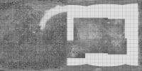
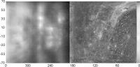
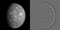
This map is a composite of the USGS shaded relief and various radar images. The poles are reprojected from published images of the polar ice patches. The equatorial parts of the side not seen by Mariner 10 are from the new Icarus paper, but here these images have been specially processed to reduce the effects of the strong north-south ambiguity in all these images. That was not done in the new paper. Areas not covered may still be reprocessed in this way, but I'm not sure how well they can be done.
Phil
-------------------- ... because the Solar System ain't gonna map itself.
Also to be found posting similar content on https://mastodon.social/@PhilStooke Maps for download (free PD: https://upload.wikimedia.org/wikipedia/comm...Cartography.pdf NOTE: everything created by me which I post on UMSF is considered to be in the public domain (NOT CC, public domain) |
|
|
|
|
|
|
Dec 9 2006, 06:37 PM
Post
#46
|
||
 Member Group: Members Posts: 106 Joined: 26-September 05 Member No.: 508 |
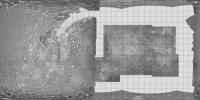
While reading this thread I realized I made the cylindrical map at http://www.lpl.arizona.edu/~rhill/alpo/mer...f/messenger.pdf, so here is my version of Phil's map.
Attached thumbnail(s)
|
|
|
|
|
|
|
Dec 9 2006, 08:10 PM
Post
#47
|
|
|
Senior Member Group: Members Posts: 3419 Joined: 9-February 04 From: Minneapolis, MN, USA Member No.: 15 |
Mucho, mucho gracias for the maps, Phil and Tayfun. To borrow a phrase... fascinating!
-the other Doug -------------------- The trouble ain't that there is too many fools, but that the lightning ain't distributed right. -Mark Twain
|
|
|
|
|
Apr 8 2007, 06:18 PM
Post
#48
|
|||
|
Solar System Cartographer Group: Members Posts: 10169 Joined: 5-April 05 From: Canada Member No.: 227 |
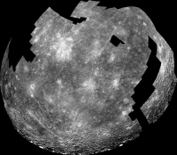
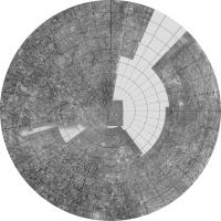
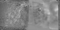
I have updated my composite map of Mercury, adding a few extra bits from remaining radar images from the paper cited earlier. Wherever possible I have merged at least two overlapping images with different radar equators to reduce the north-south ambiguity. This is probably as good as it's going to get before Messenger arrives, unless new radar images suddenly appear.
Phil
This is the northern hemisphere:
Phil -------------------- ... because the Solar System ain't gonna map itself.
Also to be found posting similar content on https://mastodon.social/@PhilStooke Maps for download (free PD: https://upload.wikimedia.org/wikipedia/comm...Cartography.pdf NOTE: everything created by me which I post on UMSF is considered to be in the public domain (NOT CC, public domain) |
||
|
|
|
||
|
Apr 8 2007, 06:19 PM
Post
#49
|
||
|
Solar System Cartographer Group: Members Posts: 10169 Joined: 5-April 05 From: Canada Member No.: 227 |
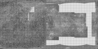
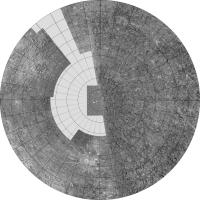
... and the southern hemisphere:
Phil -------------------- ... because the Solar System ain't gonna map itself.
Also to be found posting similar content on https://mastodon.social/@PhilStooke Maps for download (free PD: https://upload.wikimedia.org/wikipedia/comm...Cartography.pdf NOTE: everything created by me which I post on UMSF is considered to be in the public domain (NOT CC, public domain) |
|
|
|
|
|
|
Apr 8 2007, 07:34 PM
Post
#50
|
||
 Senior Member Group: Moderator Posts: 3233 Joined: 11-February 04 From: Tucson, AZ Member No.: 23 |
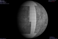
Using the above map, I ran through the first MESSENGER flyby in Celestia:
-------------------- &@^^!% Jim! I'm a geologist, not a physicist!
The Gish Bar Times - A Blog all about Jupiter's Moon Io |
|
|
|
|
|
|
Apr 8 2007, 07:48 PM
Post
#51
|
|
 Senior Member Group: Members Posts: 3648 Joined: 1-October 05 From: Croatia Member No.: 523 |
Nice view VP. One thing I always wondered about visualization programs like Celestia is what kind of map projections they assume as textures. I always thought cylindric texture maps were required, but the vertical spacing of latitude lines in your view seems to be shrinking at the poles. Is this normal or is it suggesting a spherical projection maybe?
EDIT: On second thought, latitude lines shrinking is logical when properly mapped. I'd also expect cylindrical maps to behave the same so my non-extitent expertise in maps leads me to believe Phil's map is not cylindric, correct? -------------------- |
|
|
|
|
Apr 8 2007, 08:30 PM
Post
#52
|
|
|
Solar System Cartographer Group: Members Posts: 10169 Joined: 5-April 05 From: Canada Member No.: 227 |
That is really cool, VP, thanks.
ugordan, I think you're just seeing the foreshortening one would expect near the limbs, north and south. My map was simple cylindrical, equal spacing of meridians and parallels. THere are other clindrical projections - Mercator, where spacing increases towards the poles to preserve conformality (shape), and perspective cylindrical where they get close towards the poles to preserve area. Every planetary scientist should take a course in map projections! Phil -------------------- ... because the Solar System ain't gonna map itself.
Also to be found posting similar content on https://mastodon.social/@PhilStooke Maps for download (free PD: https://upload.wikimedia.org/wikipedia/comm...Cartography.pdf NOTE: everything created by me which I post on UMSF is considered to be in the public domain (NOT CC, public domain) |
|
|
|
|
Apr 8 2007, 08:39 PM
Post
#53
|
|
|
Senior Member Group: Members Posts: 3648 Joined: 1-October 05 From: Croatia Member No.: 523 |
I see, Phil. I was under the impression that in 3D graphics, by "cylindrical" that which you describe as perspective cylindrical is implied, whereas in "spherical" map your simple cylindrical map was assumed.
I never could figure out the terminology. Then again, I don't call myself a planetary scientist so you'll have to forgive me.
-------------------- |
|
|
|
|
Apr 9 2007, 03:16 AM
Post
#54
|
|
|
Solar System Cartographer Group: Members Posts: 10169 Joined: 5-April 05 From: Canada Member No.: 227 |
I don't mean you! But I encounter so many scientists who use maps all the time and don't understand them at all... Some terrible things are done in the name of cartography, even in the best journals. Perhaps the most common is referring to any cylindrical projection as Mercator.
Phil -------------------- ... because the Solar System ain't gonna map itself.
Also to be found posting similar content on https://mastodon.social/@PhilStooke Maps for download (free PD: https://upload.wikimedia.org/wikipedia/comm...Cartography.pdf NOTE: everything created by me which I post on UMSF is considered to be in the public domain (NOT CC, public domain) |
|
|
|
|
Apr 9 2007, 03:51 PM
Post
#55
|
|
|
Senior Member Group: Members Posts: 1281 Joined: 18-December 04 From: San Diego, CA Member No.: 124 |
QUOTE (Phil Stooke @ Apr 8 2007, 08:16 PM) Some terrible things are done in the name of cartography Would this be the cynical projection?  One of the things I truly love about this forum (among many others) is how much I learn and how much threads like this inspire me to educate myself even more. I stole my one of my wife's GIS manuals for a little light night reading and what do you know, it's online as well: ESRI's Understanding Map Projections (2 MB PDF file) Beginner level, but I found it helpful.... I trust that the system works for Mars as well as Earth, though Eros, Itokawa et al might require different coordinate systems? Phil? This page has a good set of references for the cartographically challenged: Harvard GIS Resources And of course, what enthusiast autodidact post would be complete without mentioning the golden oldies: Remote Sensing Tutorial and JPL's Basics of Spaceflight -------------------- Lyford Rome
"Zis is not nuts, zis is super-nuts!" Mathematician Richard Courant on viewing an Orion test |
|
|
|
|
Apr 9 2007, 07:02 PM
Post
#56
|
|
|
Interplanetary Dumpster Diver Group: Admin Posts: 4404 Joined: 17-February 04 From: Powell, TN Member No.: 33 |
All this is well and good, Phil, but let me ask you a more sophisticated question. When you get a map out, whether it be cylindrical, mercator, or whatever, can you fold it back up properly?

-------------------- |
|
|
|
|
Apr 9 2007, 07:27 PM
Post
#57
|
|
|
Solar System Cartographer Group: Members Posts: 10169 Joined: 5-April 05 From: Canada Member No.: 227 |
Yes, Ted, I use them to make cootie-catchers... or like this:
http://www.ssc.uwo.ca/geography/spacemap/psg.jpg and http://www.ssc.uwo.ca/geography/spacemap/png.jpg which really do fold up! Phil -------------------- ... because the Solar System ain't gonna map itself.
Also to be found posting similar content on https://mastodon.social/@PhilStooke Maps for download (free PD: https://upload.wikimedia.org/wikipedia/comm...Cartography.pdf NOTE: everything created by me which I post on UMSF is considered to be in the public domain (NOT CC, public domain) |
|
|
|
|
Apr 9 2007, 08:34 PM
Post
#58
|
|
|
Senior Member Group: Members Posts: 2530 Joined: 20-April 05 Member No.: 321 |
[...]
|
|
|
|
|
Apr 10 2007, 06:05 PM
Post
#59
|
|
|
Member Group: Members Posts: 169 Joined: 17-March 06 Member No.: 709 |
The significance of all of this effort to squeeze out interpretations of Mercury's
surface from fuzzy Radar or Earth-based telescopes lies in our future efforts to image Extra-Solar Terrestrial Planets. When the Planet Imager flies (someday) after TPF, the images of those worlds will be astonishing, but they will still be only fuzzy views, much as we see Mercury today from Earth-based telescopes. However, by then, we will have had additional experience in interpreting those images because of this present effort. It will be very revealing to see what Messenger tells us, within a few months, about these present estimates of what Mercury's "Far Side" will look like. Another Phil |
|
|
|
|
Apr 10 2007, 06:09 PM
Post
#60
|
|
|
Solar System Cartographer Group: Members Posts: 10169 Joined: 5-April 05 From: Canada Member No.: 227 |
I will go on record saying that I don't believe in Skinakas.
Phil -------------------- ... because the Solar System ain't gonna map itself.
Also to be found posting similar content on https://mastodon.social/@PhilStooke Maps for download (free PD: https://upload.wikimedia.org/wikipedia/comm...Cartography.pdf NOTE: everything created by me which I post on UMSF is considered to be in the public domain (NOT CC, public domain) |
|
|
|
|
Apr 10 2007, 11:27 PM
Post
#61
|
|
|
Senior Member Group: Members Posts: 2530 Joined: 20-April 05 Member No.: 321 |
[...]
|
|
|
|
|
Apr 10 2007, 11:34 PM
Post
#62
|
|
|
Interplanetary Dumpster Diver Group: Admin Posts: 4404 Joined: 17-February 04 From: Powell, TN Member No.: 33 |
QUOTE (Phil Stooke @ Apr 10 2007, 06:09 PM) I will go on record saying that I don't believe in Skinakas. Phil Whatever Phil. Next thing you know, you'll be telling us the Spagetti Monster isn't real. -------------------- |
|
|
|
|
Apr 11 2007, 01:27 AM
Post
#63
|
|
|
Senior Member Group: Moderator Posts: 3233 Joined: 11-February 04 From: Tucson, AZ Member No.: 23 |
Why do people see vague, dark, circular albedo markings and immediately jump to large impact basin...

-------------------- &@^^!% Jim! I'm a geologist, not a physicist!
The Gish Bar Times - A Blog all about Jupiter's Moon Io |
|
|
|
|
Apr 11 2007, 03:33 AM
Post
#64
|
||
|
Member Group: Members Posts: 204 Joined: 29-June 05 Member No.: 421 |
QUOTE (Phil Stooke @ Apr 9 2007, 03:27 PM) Yes, Ted, I use them to make cootie-catchers... After this discussion I couldn't resist trying my hand at making a fold-up version of Phil's nice composite -- my first attempt at such, using a perl script from here... In case anyone is interested, the results look like this:
|
|
|
|
|
|
|
Apr 11 2007, 09:52 AM
Post
#65
|
|
|
Interplanetary Dumpster Diver Group: Admin Posts: 4404 Joined: 17-February 04 From: Powell, TN Member No.: 33 |
So that, should they get lucky, they can claim the discovery.
-------------------- |
|
|
|
|
Dec 6 2007, 01:48 PM
Post
#66
|
||
|
Member Group: Members Posts: 106 Joined: 26-September 05 Member No.: 508 |
As the first encounter is getting near, I plan to make a 4K map of Mariner 10 mosaics available so that we can make a better map together as above, what do you say?
Attached thumbnail(s)
|
|
|
|
|
|
|
Dec 6 2007, 07:22 PM
Post
#67
|
|
|
Solar System Cartographer Group: Members Posts: 10169 Joined: 5-April 05 From: Canada Member No.: 227 |
Yes, this is a good idea. It will be interesting to see the maps evolve from just Mariner 10 through each of the Messenger flybys, to the final orbital phase.
Phil -------------------- ... because the Solar System ain't gonna map itself.
Also to be found posting similar content on https://mastodon.social/@PhilStooke Maps for download (free PD: https://upload.wikimedia.org/wikipedia/comm...Cartography.pdf NOTE: everything created by me which I post on UMSF is considered to be in the public domain (NOT CC, public domain) |
|
|
|
|
Dec 6 2007, 07:34 PM
Post
#68
|
|
|
Senior Member Group: Members Posts: 2530 Joined: 20-April 05 Member No.: 321 |
[...]
|
|
|
|
|
Dec 6 2007, 08:21 PM
Post
#69
|
|
|
Merciless Robot Group: Admin Posts: 8784 Joined: 8-December 05 From: Los Angeles Member No.: 602 |
QUOTE (JRehling @ Dec 6 2007, 11:34 AM) We're going to see a brand new planet when those first Messenger images come in. Yeah, I think that's a truism based on experience. Seems like our initial flybys almost invariably miss the most interesting features of a given target for whatever reason... -------------------- A few will take this knowledge and use this power of a dream realized as a force for change, an impetus for further discovery to make less ancient dreams real.
|
|
|
|
|
Dec 6 2007, 09:01 PM
Post
#70
|
||
|
Member Group: Members Posts: 378 Joined: 21-April 05 From: Portugal Member No.: 347 |
Hi,
Ok, here's the familiar Mercury map with a color/albedo overlay from two Mariner 10 images made from different filters. Colors are approximate and perhaps a little to saturated but it's a start.
-------------------- _______________________
www.astrosurf.com/nunes |
|
|
|
|
|
|
Dec 6 2007, 09:39 PM
Post
#71
|
||
|
Member Group: Members Posts: 106 Joined: 26-September 05 Member No.: 508 |
Here it is. Some notes about the map: It was constructed by me from the mosaics created for the Atlas of Mercury by NASA, (thanks to NSSDC for supplying the digital data). Becuse of discrepancies in the original mosaics this map may have errors as large as a few degrees. The original is 12K but only 4K fits to the 1MB limit here. With other regions added we may have to compress it more.
It is in simple cylindrical projection with 0 degrees longitude at the center. Some of the missing parts are the missing parts of the mosaics which are possible to fill with Mariner 10 data. First I think we should do this. And please add the radar data last as they have North-South ambiguity.
Attached thumbnail(s)
|
|
|
|
|
|
|
Dec 7 2007, 09:33 AM
Post
#72
|
||
|
Member Group: Members Posts: 106 Joined: 26-September 05 Member No.: 508 |
And here is version 2 with some fills.
Attached thumbnail(s)
|
|
|
|
|
|
|
Dec 7 2007, 05:58 PM
Post
#73
|
||
 Member Group: Members Posts: 146 Joined: 23-August 06 From: Vriezenveen, Netherlands Member No.: 1067 |
Here's a map of Mercury that I've been using for a couple of months now, I've added some radar information that's available on the web.
|
|
|
|
|
|
|
Dec 8 2007, 02:11 AM
Post
#74
|
||
|
Newbie Group: Members Posts: 16 Joined: 8-August 07 Member No.: 3138 |
QUOTE (CAP-Team @ Dec 7 2007, 12:58 PM) Here's a map of Mercury that I've been using for a couple of months now, I've added some radar information that's available on the web.
This map includes recent (reported within last 2 wks) amateur imaging (290-360 deg) by John Boudreau and our SOAR telescope imaging from earlier in the yr (185-290 deg), only to +-70 deg lat shown however. Alignment along longitudes of bright features (all rayed radar craters) is an artifact of the phase correction. Agreement with rayed radar craters and their diameters is given in our paper. http://stew.physics.unc.edu/MercuryComposite.jpg ( large image removed, replaced with link. Not everyone has 100 Mbit internet and 2500 pixel wide monitors - DOUG) |
|
|
|
|
|
|
Dec 8 2007, 02:42 AM
Post
#75
|
|
 Senior Member Group: Admin Posts: 4763 Joined: 15-March 05 From: Glendale, AZ Member No.: 197 |
Welcome Gerald. Thanks for the links to your paper.
-------------------- If Occam had heard my theory, things would be very different now.
|
|
|
|
|
Dec 8 2007, 10:17 AM
Post
#76
|
|
|
Member Group: Members Posts: 106 Joined: 26-September 05 Member No.: 508 |
Hi gcecil, thanks for the map but it seems to have some serious scale problems, Mariner 10 data covers more longitudes than it should. I think there was a mistake in compositing.
|
|
|
|
|
Dec 8 2007, 11:46 AM
Post
#77
|
|
|
Senior Member Group: Members Posts: 1870 Joined: 20-February 05 Member No.: 174 |
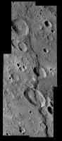
Mariner 10 took a series of approach <crescent> data for something like 6 days and outgoing data for maybe 3. Granted, the furthest out data is pretty horribly low rez, but the data shows stuff beyond the terminator on both approach and flyout. That's how the large crater "Mozart", south of Caloris, was discovered. It's not in the high rez mosaics.
Some of the data was lost or truncated by camera wander due to Mariner's large attitude control slop, and I vaguely recall some color band data may have been smeared by the wander, or some data was over-exposed, but I've always wanted to see the several frame zoom "movie" from approach and flyout, both at native resolution, and rescaled to a uniform diameter. |
|
|
|
|
Dec 8 2007, 12:13 PM
Post
#78
|
|
|
Member Group: Members Posts: 106 Joined: 26-September 05 Member No.: 508 |
I am not sure if edstrick's post is an answer to my post but let me make it clear: Mariner 10 high res data covers 190 to 10 degrees longitude, not 190 to -10 as in gcecil's map. That map has a scale problem.
|
|
|
|
|
Dec 8 2007, 01:19 PM
Post
#79
|
||
|
Newbie Group: Members Posts: 16 Joined: 8-August 07 Member No.: 3138 |
QUOTE (Tayfun Öner @ Dec 8 2007, 07:13 AM) I am not sure if edstrick's post is an answer to my post but let me make it clear: Mariner 10 high res data covers 190 to 10 degrees longitude, not 190 to -10 as in gcecil's map. That map has a scale problem. Yup, scale was messed up when I cutoff at +/-70 lat. Fixed now, so reposting with proper format. Thank you! This map
|
|
|
|
|
|
|
Dec 8 2007, 02:35 PM
Post
#80
|
||
|
Member Group: Members Posts: 106 Joined: 26-September 05 Member No.: 508 |
Here is Version 3 with optical data added from Baumgardner et al. Cosmetically corrected for Celestia.
Attached thumbnail(s)
|
|
|
|
|
|
|
Dec 9 2007, 10:11 AM
Post
#81
|
|
|
Senior Member Group: Members Posts: 1870 Joined: 20-February 05 Member No.: 174 |
I didn't spot the scale problem, I was just pointing that to some extend, Mariner 10 converage extends beyond the high-rez mosaic's terminations at the terminators.
Did Mariner really say "I'll be back!"? |
|
|
|
|
Dec 14 2007, 03:56 AM
Post
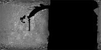
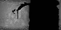
#82
|
||
|
Interplanetary Dumpster Diver Group: Admin Posts: 4404 Joined: 17-February 04 From: Powell, TN Member No.: 33 |
Here is an example of a Mariner set that shows a bit beyond what the high resolution images show. This is the same set of images, processed to look relatively natural on the left and with heavy high-pass filtering on the right.
-------------------- |
|
|
|
|
|
|
Dec 30 2007, 09:13 AM
Post
#83
|
||
 Member Group: Members Posts: 568 Joined: 20-April 05 From: Silesia Member No.: 299 |
I recognize that many of you are waiting for new images of Mercury, but you can't also see old images.
Tape MVE_033 Image 091 (29 November 1973) -------------------- Free software for planetary science (including Cassini Image Viewer).
http://members.tripod.com/petermasek/marinerall.html |
|
|
|
|
|
|
Jan 4 2008, 09:55 PM
Post
#84
|
|||||
|
Interplanetary Dumpster Diver Group: Admin Posts: 4404 Joined: 17-February 04 From: Powell, TN Member No.: 33 |
I have been playing around with some Mariner-10 shots. I experimented with color, but Mariner 10's camera had such a weird filter selection that, when combined with calibration issues, make things really difficult.
Here is a cleaner view of the south polar view I did a while back, both in original form and from a high pass filter. There is a larger mosaic, but since it depends on a heavy amount of reprojection, I decided to stick with the wide angle data, as Mercury's topography makes significant reprojection obvious.
Here is the 3rd encounter Discovery Rupes mosaic, with a small gapfill from stacked first-encounter images to fill the sliver between the two lower images. Also, I did a stack of the "Discovery Dome" area using third encounter images.
-------------------- |
||||
|
|
|
||||
|
Jan 4 2008, 10:41 PM
Post
#85
|
|
|
Senior Member Group: Members Posts: 2530 Joined: 20-April 05 Member No.: 321 |
[...]
|
|
|
|
|
Jan 4 2008, 10:44 PM
Post
#86
|
|
|
Interplanetary Dumpster Diver Group: Admin Posts: 4404 Joined: 17-February 04 From: Powell, TN Member No.: 33 |
True-color is such a relative thing....I think even Messenger stuff might go through a few variations as we have seen in color images from many early missions....the problem is the lack of a standard for subtle balancing work. By the way, if anyone downloaded the image right after I posted it, I posted the wrong file...it has now been corrected.
-------------------- |
|
|
|
|
Jan 4 2008, 10:57 PM
Post
#87
|
|
|
Senior Member Group: Members Posts: 2530 Joined: 20-April 05 Member No.: 321 |
[...]
|
|
|
|
|
Jan 5 2008, 12:04 AM
Post
#88
|
|
|
Interplanetary Dumpster Diver Group: Admin Posts: 4404 Joined: 17-February 04 From: Powell, TN Member No.: 33 |
What I am trying to say is that it might take a while before images can be calibrated to the point of providing color of the quality of, for example, Cassini images. For the other planets, we at least have good earthbased color data. Mercury images, on the other hand, are so damaged by atmospheric refraction and (in daylight) scattered sunlight that they don't provide much of a reference point. In other words, I can see the color images being produced two years from now looking very different from the ones we will see in the next few weeks.
Incidentally, Mariner 10, while having odd filters, had a great camera, but unfortunately, as has been mentioned before, the camera pointing resembles footage from an drunken camera man. That makes the images very hard to assemble, especially using color. I always wondered why Mark Robinson and his team only produced a color ratio map of a small area. After trying to work with the data, I understand. -------------------- |
|
|
|
|
Jan 5 2008, 12:42 AM
Post
#89
|
|
|
Senior Member Group: Members Posts: 3648 Joined: 1-October 05 From: Croatia Member No.: 523 |
I personally think any color uncertainties in the first images will be smaller than any comparative "ground-truth" later, onboard spectrometer corrections will suggest. Mercury, after all, isn't likely to be a very spectrally complex place like Jupiter, Io or Saturn. It will probably have gentle spectral slopes and that's where even discrete filter MDIS composites can come very close in "true color" to what a more precise integration through many spectral wavelengths (approximating the actual spectral curve to a good degree) would give. Messenger carries a spectrometer, although apparently not an imaging one. MASCS will probably be good enough anyway, just like Cassini's VIMS can be used at Saturn.
The MER rovers don't have that kind of training tool and all their surface "true" color views are basically generated on the basis of being the most probable result of solving some integral equations IIRC. I'd like to know if Cassini image products were trained on groundbased imagery (I know my first reactions to the first Saturn color shots were how different it looks than from other earthbased views I saw) because the vantage points were different and direct color calibration would be difficult due to phase angle effects etc. There is certainly variation in color results even today from CICLOPS image releases, although less than before. I'm saying that with good spectrometers onboard you don't even need groundbased observations for good color quality and this might very well turn out to be the case with Mercury. Color me happy if Mercury doesn't turn out as spectrally grey as our own Moon. Even a brownish hue is some personality. -------------------- |
|
|
|
|
Jan 5 2008, 01:20 AM
Post
#90
|
|
|
Interplanetary Dumpster Diver Group: Admin Posts: 4404 Joined: 17-February 04 From: Powell, TN Member No.: 33 |
I think the lack of color is the problem. With color variations being so faint, balancing is made very difficult. For "natural" views, this may be only subtly visible, but it may effect the warm/cool color appearance, which is why I say there may be a lot of variation at first (it really depends just what color Mercury really is to see whether this materializes). I have never thought it too terribly important to replicate the human eye in planetary images - the RGB response of our eyes is so arbitrary for planetary targets that unless we are generating graphics for astronaut training, using other wavelengths that better highlight a world's compositional variations is a great technique. However the Mariner 10 filters set is just weird. It does have a dedicated yellow filter, but it was seldom (if ever) used. There is so much overlap between the filters used here (UV = blue, blue = green, and "minus UV" = red) that isolating three channels is quite treacherous.
On a more abstract level, I often wonder how much variation there is between different sets of eyes. I have gotten into long debates with people who are looking through my telescope and could swear it has a cool hue while others swear it has a warm hue. I have noticed that on many nights, it looks cool in my left eye and warm in my right eye. Perhaps this is what gives me my opinion on color. -------------------- |
|
|
|
|
Jan 5 2008, 05:46 AM
Post
#91
|
|
|
Senior Member Group: Members Posts: 2530 Joined: 20-April 05 Member No.: 321 |
[...]
|
|
|
|
|
Jan 6 2008, 04:19 AM
Post
#92
|
|
 Director of Galilean Photography Group: Members Posts: 896 Joined: 15-July 04 From: Austin, TX Member No.: 93 |
QUOTE (tedstryk @ Jan 4 2008, 07:20 PM) On a more abstract level, I often wonder how much variation there is between different sets of eyes. I have gotten into long debates with people who are looking through my telescope and could swear it has a cool hue while others swear it has a warm hue. I have noticed that on many nights, it looks cool in my left eye and warm in my right eye. Perhaps this is what gives me my opinion on color. It's quite common, apparently. I notice even during normal lighting that one of my eyes is slightly warmer than the other. Another thing could be contacts, most are tinted slightly blue and could give a cooling effect. In talking with my optometrist, most people do have a difference in perceived color between their eyes, but never notice it. -------------------- Space Enthusiast Richard Hendricks
-- "The engineers, as usual, made a tremendous fuss. Again as usual, they did the job in half the time they had dismissed as being absolutely impossible." --Rescue Party, Arthur C Clarke Mother Nature is the final inspector of all quality. |
|
|
|
|
Jan 6 2008, 05:35 AM
Post
#93
|
|
|
Merciless Robot Group: Admin Posts: 8784 Joined: 8-December 05 From: Los Angeles Member No.: 602 |
My brother is both color-blind (red-green, which apparently enhances contrast perception) and an optometrist; I'll ask his opinion, this is interesting.
-------------------- A few will take this knowledge and use this power of a dream realized as a force for change, an impetus for further discovery to make less ancient dreams real.
|
|
|
|
|
Jan 7 2008, 07:03 PM
Post
#94
|
|||
|
Member Group: Members Posts: 568 Joined: 20-April 05 From: Silesia Member No.: 299 |
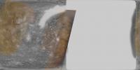
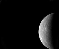
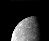
Mariner 10 - First encounter with Mercury.
Image FDS0025326 - one day before closest approach (87 day of year 74)
Image FDS0025337 - one day before closest approach (87 day of year 74) -------------------- Free software for planetary science (including Cassini Image Viewer).
http://members.tripod.com/petermasek/marinerall.html |
||
|
|
|
||
|
Jan 7 2008, 10:00 PM
Post
#95
|
||
|
Interplanetary Dumpster Diver Group: Admin Posts: 4404 Joined: 17-February 04 From: Powell, TN Member No.: 33 |
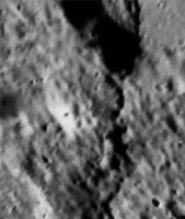
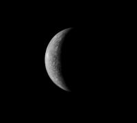
Here is a more distant approach view showing a lot of the uncharted territory.
-------------------- |
|
|
|
|
|
|
Jan 9 2008, 06:47 PM
Post
#96
|
|||
|
Member Group: Members Posts: 568 Joined: 20-April 05 From: Silesia Member No.: 299 |
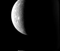
Mariner 10 - First encounter with Mercury (March 29, 1974, 2046 UT)
Image FDS001341 (March 30, 1974, 1215 UT)
Image FDS001220 (March 30, 1974, 1200 UT) -------------------- Free software for planetary science (including Cassini Image Viewer).
http://members.tripod.com/petermasek/marinerall.html |
||
|
|
|
||
|
Jan 9 2008, 06:52 PM
Post
#97
|
|
|
Senior Member Group: Members Posts: 2530 Joined: 20-April 05 Member No.: 321 |
[...]
|
|
|
|
|
Jan 10 2008, 05:25 AM
Post
#98
|
||
|
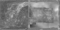
Interplanetary Dumpster Diver Group: Admin Posts: 4404 Joined: 17-February 04 From: Powell, TN Member No.: 33 |
For the record, since the Mariner-10 outbound mosaic on the photojournal is so small, I have worked for a while (off and on for nearly a year and there are still problems) on creating a large mosaic. Mariner-10 images are so damn hard to work with. Also, with the wild camera pointing, annoying holes show up. I used a low resolution color overlay. I have raced to make a presentable version, since in a few days no one will care.
I don't know that Messenger will solve the problem entirely - they still, for example, use the hideous over-exaggerated color views from the Voyager Saturn encounters even with Cassini data available.
-------------------- |
|
|
|
|
|
|
Jan 10 2008, 06:55 PM
Post
#99
|
|
|
Senior Member Group: Members Posts: 2530 Joined: 20-April 05 Member No.: 321 |
[...]
|
|
|
|
|
Jan 27 2008, 08:38 AM
Post
#100
|
|
|
Senior Member Group: Members Posts: 1870 Joined: 20-February 05 Member No.: 174 |
I never understood why they didn't include that data <and from the flyout> in the maps, low-rez as it is. They've always sort of pretended that it didn't exist, other than the outbound terminator visibility of Mozart crater.
|
|
|
|
|

|
Lo-Fi Version | Time is now: 26th May 2024 - 10:38 PM |
|
RULES AND GUIDELINES Please read the Forum Rules and Guidelines before posting. IMAGE COPYRIGHT |
OPINIONS AND MODERATION Opinions expressed on UnmannedSpaceflight.com are those of the individual posters and do not necessarily reflect the opinions of UnmannedSpaceflight.com or The Planetary Society. The all-volunteer UnmannedSpaceflight.com moderation team is wholly independent of The Planetary Society. The Planetary Society has no influence over decisions made by the UnmannedSpaceflight.com moderators. |
SUPPORT THE FORUM Unmannedspaceflight.com is funded by the Planetary Society. Please consider supporting our work and many other projects by donating to the Society or becoming a member. |
|