Radar And Mariner 10, Best possible mapping, pre-Messenger |

  |
Radar And Mariner 10, Best possible mapping, pre-Messenger |
 May 22 2006, 08:45 AM May 22 2006, 08:45 AM
Post
#31
|
|
|
Senior Member  Group: Members Posts: 1870 Joined: 20-February 05 Member No.: 174 |
Mariner 10 and Voyager had very similar camera systems. Selenium Sulfide vidicon tubes, who's design went back to Mariner 69 and maybe some Mariner Mars 64 heritage.
Mariner 4 had a horrendous light leak -- PAST the shutter mechanism -- and impossibly limited data storage. Mariners 6 and 7 tried to solve the data storage problem with a combined analog/digital dual recorder system that *SORT OF* worked but was compromized by tape-crud contamination buildup on the analog recorder heads. Mariner 9 upgraded to all digital, 9 bit (!) data and could stuff about 33 pics on a tape recorder load, doing 2 orbits a day and dumping 1 tape load just after a periapsis and the second just before the second periapsis (only one 210 foot DSN dish at the time). Unfortunately, the Mariner 69 and 71 data were badly corrupted by residual images. Approach images by Mariner 9 show multiple ghost imagtes of Mars in subsequent images in the sequence, slowly fading with each following shot. Mariner 10 (and Viking orbiters, and Voyagers) used brilliant (literally) brute force engineering to eliminate the residual image problem. After each frame, they turned lightbulbs on INSIDE the cameras, then erased the light-flood staturated image so each image had an essentially perfectly repeatable residual image after erasure. The noisy Mariner 10 data are from the Mercury flybys, where the range to Earth was right a the limit of the experimental 114,000 (or 148,000 or whatever then number was) bits / sec transmission rate. They traded off getting a LOT of salt-and-pepper speckled images at Mercury for fewer but clean images. The highest resolution images during the first flyby were tape recorded and played back later, the tape recorder failed before either the second (I think) or third flyby. DSN failure at the third flyby limited imaging to the central 1/4 or so of each frame due to a forced lower data rate, losing contiguous targeted high resolution mapping of selected targets <damn>. |
 |
 
|
|
May 22 2006, 01:54 PM
Post
#32
|
|
 Senior Member Group: Members Posts: 2488 Joined: 17-April 05 From: Glasgow, Scotland, UK Member No.: 239 |
oDoug:
Charles A Cross did an interesting mapping job on Mercury in the late 1970s - it'll be interesting to see if his work holds up. He published his maps (with Patrick Moore) but sadly then died. Update: Amazon have this book listed for £25 (there's a Mars volume too). Hardcover 48 pages (August 1977) Publisher: Mitchell Beazley ISBN: 0855331151 Bob Shaw -------------------- Remember: Time Flies like the wind - but Fruit Flies like bananas!
|
|
|
|
|
May 22 2006, 03:35 PM
Post
#33
|
|
|
Solar System Cartographer Group: Members Posts: 10151 Joined: 5-April 05 From: Canada Member No.: 227 |
Charles Cross did some interesting work. He let me copy some of his moon maps when I was a youngster just getting into the biz of planetary mapping many moons ago. - and he gave me a copy of the Mariner 6/7 map of Mars which is still one of my treasures. Then he did some Mariner 6/7 near-encounter mapping for the Rand Corporation, and then the Mercury and Mars atlases with Patrick Moore. Moore told me he had just completed Voyager mapping of the Galilean Satellites when he died. Those maps, which I would rent out an elderly relative to see, apparently disappeared into the archives of the BAA. Maybe somebody could find them...
Phil -------------------- ... because the Solar System ain't gonna map itself.
Also to be found posting similar content on https://mastodon.social/@PhilStooke Maps for download (free PD: https://upload.wikimedia.org/wikipedia/comm...Cartography.pdf NOTE: everything created by me which I post on UMSF is considered to be in the public domain (NOT CC, public domain) |
|
|
|
|
May 22 2006, 03:47 PM
Post
#34
|
|
|
Founder Group: Chairman Posts: 14432 Joined: 8-February 04 Member No.: 1 |
I am a BAA member - give me some specifics and I'll try and get to the BAA library next time I'm down with my laptop+scanner
Dorp me an email with the Info phil, and I'll see what I can do. Doug |
|
|
|
|
May 22 2006, 05:07 PM
Post
#35
|
|
|
Solar System Cartographer Group: Members Posts: 10151 Joined: 5-April 05 From: Canada Member No.: 227 |
I'm sorry, Doug, I don't know any more than that. Cross made maps of the four Galilean satellites just before he died, and they apparently ended up at the BAA. You would have to see if they have his papers there. I think the maps were made for another atlas with Patrick Moore, but then were not used. Possibly they were not finished enough. After that, the quality of mapping in Moore's atlases went seriously downhill. I expect it was handed over to some graphics contractors who knew nothing about the subject.
He did great work, one of the few amateur cartographers who really became involved in planetary exploration, with his work for Rand on Mariners 6 and 7. A commemorative website devoted to his work would be a really nice resource. Phil -------------------- ... because the Solar System ain't gonna map itself.
Also to be found posting similar content on https://mastodon.social/@PhilStooke Maps for download (free PD: https://upload.wikimedia.org/wikipedia/comm...Cartography.pdf NOTE: everything created by me which I post on UMSF is considered to be in the public domain (NOT CC, public domain) |
|
|
|
|
May 23 2006, 03:00 AM
Post
#36
|
||
|
Member Group: Members Posts: 169 Joined: 17-March 06 Member No.: 709 |
QUOTE (tedstryk @ May 20 2006, 12:40 PM)  Thank you for this link. There is one mosaic, from the link above, from Mariner 10's second encounter with Mercury, that is close to what was in Sky and Telecope, namely this one.
However, as noted on the website, the gores in this image were to be filled in using images from the 1st and 3rd Mercury encounter. I believe that that was the mosiac that I saw in S and T. Does anyone have access to that image? I really liked it as it showed the entire hemisphere of Mercury, that was imaged by Mariner 10, in one view. Another Phil |
|
|
|
|
|
| Guest_DonPMitchell_* |
May 23 2006, 04:00 AM
Post
#37
|
|
Guests |
Do you have the ISIS calibration data for the Mariner-10 camera? Find the isisdist machine, where ever it is at the moment (the URL I used doesn't work now...welcome to NASA's churning domain names!). If you find it, look in isis/apps/mariner10. There are dark-current images, blemish maps and such.
Drop me an email if you want the FORTRAN code for linearizing the images. The calibration data is 260 MBytes, so try to find that online. |
|
|
|
|
May 27 2006, 05:06 AM
Post
#38
|
|
|
Member Group: Members Posts: 169 Joined: 17-March 06 Member No.: 709 |
QUOTE (Malmer @ May 21 2006, 04:38 PM) That might be overstating things a little... but thank you very much  I make my living making 3D effects for commercials all day long... the ultimate in turdpolishing. So I can cheat my way into making pretty pictures from source that are less than optimal... I have been playing a little with the mariner 10 raw data and its actually pretty fantastic material. strange that we see so little of it displayed. The largest images of venus i have ever seen are in there. beautiful stuff. Mattias Here is the link to Malmer's "Big Io" image. It is truly one of the most beautiful space images that I have ever seen. I congratulate you on some excellent work. http://syndicate.se/image/space/io_big.jpg I do have a few questions. What is the source of the Io image? Did you process one Galileo image of Io or is this a mosaic? Also, do you know the date that the images were taken? Another Phil |
|
|
|
|
Dec 7 2006, 01:52 AM
Post
#39
|
|
|
Member Group: Members Posts: 315 Joined: 1-October 06 Member No.: 1206 |
Outstanding new Arecibo radar images of equatorial and mid latitudes discussed here:
http://www.sciencedirect.com/science?_ob=M...=/sdarticle.pdf P |
|
|
|
|
Dec 7 2006, 02:57 AM
Post
#40
|
|
|
Solar System Cartographer Group: Members Posts: 10151 Joined: 5-April 05 From: Canada Member No.: 227 |
Yes, that is an excellent article.
Phil -------------------- ... because the Solar System ain't gonna map itself.
Also to be found posting similar content on https://mastodon.social/@PhilStooke Maps for download (free PD: https://upload.wikimedia.org/wikipedia/comm...Cartography.pdf NOTE: everything created by me which I post on UMSF is considered to be in the public domain (NOT CC, public domain) |
|
|
|
|
Dec 7 2006, 04:49 AM
Post
#41
|
|
 Senior Member Group: Members Posts: 3419 Joined: 9-February 04 From: Minneapolis, MN, USA Member No.: 15 |
Too bad it would cost me $30USD to take a look at it...
 -the other Doug -------------------- The trouble ain't that there is too many fools, but that the lightning ain't distributed right. -Mark Twain
|
|
|
|
|
Dec 8 2006, 01:55 PM
Post
#42
|
|
 Interplanetary Dumpster Diver Group: Admin Posts: 4404 Joined: 17-February 04 From: Powell, TN Member No.: 33 |
-------------------- |
|
|
|
|
Dec 8 2006, 03:56 PM
Post
#43
|
|
 Member Group: Members Posts: 159 Joined: 4-March 06 Member No.: 694 |
I always wanted some good full disk coverage of Mercury. And I thank the person who put up the link to article for a free view!
-------------------- I call heaven and earth to witness against you this day, that I have set before thee life and death, the blessing and the curse; therefore choose life, that thou mayest live, thou and thy seed.
- Opening line from episode 13 of "Cosmos" |
|
|
|
|
Dec 8 2006, 05:17 PM
Post
#44
|
|
|
Interplanetary Dumpster Diver Group: Admin Posts: 4404 Joined: 17-February 04 From: Powell, TN Member No.: 33 |
That would be the first author, John Harmon.
-------------------- |
|
|
|
|
Dec 9 2006, 05:58 PM
Post
#45
|
||
|
Solar System Cartographer Group: Members Posts: 10151 Joined: 5-April 05 From: Canada Member No.: 227 |
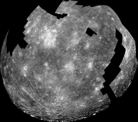
This map is a composite of the USGS shaded relief and various radar images. The poles are reprojected from published images of the polar ice patches. The equatorial parts of the side not seen by Mariner 10 are from the new Icarus paper, but here these images have been specially processed to reduce the effects of the strong north-south ambiguity in all these images. That was not done in the new paper. Areas not covered may still be reprocessed in this way, but I'm not sure how well they can be done.
Phil
-------------------- ... because the Solar System ain't gonna map itself.
Also to be found posting similar content on https://mastodon.social/@PhilStooke Maps for download (free PD: https://upload.wikimedia.org/wikipedia/comm...Cartography.pdf NOTE: everything created by me which I post on UMSF is considered to be in the public domain (NOT CC, public domain) |
|
|
|
|
|
|

|
Lo-Fi Version | Time is now: 26th April 2024 - 08:10 PM |
|
RULES AND GUIDELINES Please read the Forum Rules and Guidelines before posting. IMAGE COPYRIGHT |
OPINIONS AND MODERATION Opinions expressed on UnmannedSpaceflight.com are those of the individual posters and do not necessarily reflect the opinions of UnmannedSpaceflight.com or The Planetary Society. The all-volunteer UnmannedSpaceflight.com moderation team is wholly independent of The Planetary Society. The Planetary Society has no influence over decisions made by the UnmannedSpaceflight.com moderators. |
SUPPORT THE FORUM Unmannedspaceflight.com is funded by the Planetary Society. Please consider supporting our work and many other projects by donating to the Society or becoming a member. |
|