Traversing the Clay-Bearing Unit Along the Base of VRR, Site 73-79, sol 2297-2695, 22 Jan 2019-3 Mar 2020 |

  |
Traversing the Clay-Bearing Unit Along the Base of VRR, Site 73-79, sol 2297-2695, 22 Jan 2019-3 Mar 2020 |
 Feb 2 2020, 08:20 AM Feb 2 2020, 08:20 AM
Post
#541
|
|
|
Member  Group: Members Posts: 282 Joined: 18-June 04 Member No.: 84 |
QUOTE (charborob @ Jan 31 2020, 08:16 PM)  Sol 2657 Rmastcam: [attachment=45599:sol_2657_Rmastcam.jpg] wow! some really striking cross bedding there! |
 |
 
|
|
Feb 2 2020, 09:10 PM
Post
#542
|
||
|
Senior Member Group: Members Posts: 2822 Joined: 22-April 05 From: Ridderkerk, Netherlands Member No.: 353 |
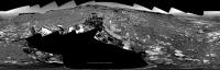
The Navcam L view on Sol 2661.
Jan van Driel
|
|
|
|
|
|
|
Feb 2 2020, 10:54 PM
Post
#543
|
||
|
Solar System Cartographer Group: Members Posts: 10153 Joined: 5-April 05 From: Canada Member No.: 227 |
Quite an incredible place! I only just finished projecting Jan's panorama from 2 sols ago and now there's another one. OK, here is sol 2659. Map update to follow shortly.
Phil
-------------------- ... because the Solar System ain't gonna map itself.
Also to be found posting similar content on https://mastodon.social/@PhilStooke Maps for download (free PD: https://upload.wikimedia.org/wikipedia/comm...Cartography.pdf NOTE: everything created by me which I post on UMSF is considered to be in the public domain (NOT CC, public domain) |
|
|
|
|
|
|
Feb 3 2020, 12:15 AM
Post
#544
|
||
|
Solar System Cartographer Group: Members Posts: 10153 Joined: 5-April 05 From: Canada Member No.: 227 |
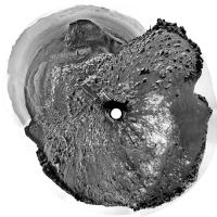
OK, here is the sol 2661 panorama, kindly supplied by Jan, in a circular format. Comparison with the last one shows how we moved east and south towards the edge of the Pediment's upper layer. It looks to me as if there is no actual view of the contact between the cap rock and the brighter slope rocks, so I expect we will descend again soon and start circumnavigating the Pediment, perhaps looking out for a spot where a contact is accessible.
The geometry of this one was a bit tricky! Phil
-------------------- ... because the Solar System ain't gonna map itself.
Also to be found posting similar content on https://mastodon.social/@PhilStooke Maps for download (free PD: https://upload.wikimedia.org/wikipedia/comm...Cartography.pdf NOTE: everything created by me which I post on UMSF is considered to be in the public domain (NOT CC, public domain) |
|
|
|
|
|
|
Feb 3 2020, 12:44 AM
Post
#545
|
||
|
Senior Member Group: Members Posts: 1074 Joined: 21-September 07 From: Québec, Canada Member No.: 3908 |
Sol 2659 Rmastcam:
|
|
|
|
|
|
|
Feb 4 2020, 06:34 AM
Post
#546
|
|
 Member Group: Members Posts: 146 Joined: 22-November 14 From: Bormida (SV) - Italy Member No.: 7348 |
Hi to all,
I haven't written here for a long time  Here are a couple of the last de-bayers:  
-------------------- |
|
|
|
|
Feb 4 2020, 01:26 PM
Post
#547
|
||
|
Senior Member Group: Members Posts: 1074 Joined: 21-September 07 From: Québec, Canada Member No.: 3908 |
Sol 2663 Rmastcam:
|
|
|
|
|
|
|
Feb 4 2020, 01:42 PM
Post
#548
|
||
|
Senior Member Group: Members Posts: 1074 Joined: 21-September 07 From: Québec, Canada Member No.: 3908 |
Sol 2661 Rmastcam:
|
|
|
|
|
|
|
Feb 4 2020, 08:15 PM
Post
#549
|
||
|
Senior Member Group: Members Posts: 2822 Joined: 22-April 05 From: Ridderkerk, Netherlands Member No.: 353 |
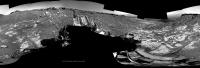
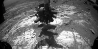
The Navcam L view on Sol 2664.
Jan van Driel
|
|
|
|
|
|
|
Feb 5 2020, 04:53 AM
Post
#550
|
||
|
Member Group: Members Posts: 111 Joined: 14-March 05 From: Vastitas Borealis Member No.: 193 |
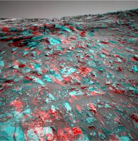
In this anaglyph from sol 2661, what in 2D images looks like an unbroken bulwark at the edge of the Pediment, appears rather surprisingly easy to ascend. From this point a good part of the top surface was in view already. There's a gently sloping ramp to the right of and beyond the nearby heap of stones that could offer a perfect way up for the rover (if you ask me).
Attached thumbnail(s)
|
|
|
|
|
|
|
Feb 5 2020, 12:34 PM
Post
#551
|
||
 Senior Member Group: Members Posts: 2428 Joined: 30-January 13 From: Penang, Malaysia. Member No.: 6853 |
3 frame F-HazCam animated GIF of the pre-drill load test during sol 2665.
|
|
|
|
|
|
|
Feb 5 2020, 02:58 PM
Post
#552
|
||
 Member Group: Members Posts: 684 Joined: 24-July 15 Member No.: 7619 |
QUOTE (jvandriel @ Feb 4 2020, 09:15 PM) The Navcam L view on Sol 2664. Jan van Driel
Amazing how many perched / stacked rocks there are. Has Curi ever intentionally knocked over a pillar or yardang to expose a fresh rock surface? |
|
|
|
|
|
|
Feb 6 2020, 12:13 AM
Post
#553
|
||
|
Solar System Cartographer Group: Members Posts: 10153 Joined: 5-April 05 From: Canada Member No.: 227 |
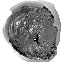
Sol 2664, Jan's panorama in circular form. We moved just a bit down the slope to a more stable location for drilling.
Phil
-------------------- ... because the Solar System ain't gonna map itself.
Also to be found posting similar content on https://mastodon.social/@PhilStooke Maps for download (free PD: https://upload.wikimedia.org/wikipedia/comm...Cartography.pdf NOTE: everything created by me which I post on UMSF is considered to be in the public domain (NOT CC, public domain) |
|
|
|
|
|
|
Feb 6 2020, 02:55 PM
Post
#554
|
||
|
Senior Member Group: Members Posts: 1074 Joined: 21-September 07 From: Québec, Canada Member No.: 3908 |
Another part of the sol 2663 Rmastcam panorama:
|
|
|
|
|
|
|
Feb 8 2020, 02:26 AM
Post
#555
|
||
|
Senior Member Group: Members Posts: 2428 Joined: 30-January 13 From: Penang, Malaysia. Member No.: 6853 |
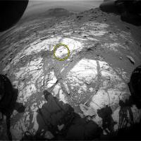
Drill hole at Hutton features in this F-HazCam from sol 2668.
Judging from the tailings it could be the 24th successful sample hole in Mars!
|
|
|
|
|
|
|

|
Lo-Fi Version | Time is now: 29th April 2024 - 05:58 PM |
|
RULES AND GUIDELINES Please read the Forum Rules and Guidelines before posting. IMAGE COPYRIGHT |
OPINIONS AND MODERATION Opinions expressed on UnmannedSpaceflight.com are those of the individual posters and do not necessarily reflect the opinions of UnmannedSpaceflight.com or The Planetary Society. The all-volunteer UnmannedSpaceflight.com moderation team is wholly independent of The Planetary Society. The Planetary Society has no influence over decisions made by the UnmannedSpaceflight.com moderators. |
SUPPORT THE FORUM Unmannedspaceflight.com is funded by the Planetary Society. Please consider supporting our work and many other projects by donating to the Society or becoming a member. |
|