Atop/Around the Greenheugh Pediment, Site 79-, sol 2695-3199, 3 Mar 2020-6 Aug 2021 |

  |
Atop/Around the Greenheugh Pediment, Site 79-, sol 2695-3199, 3 Mar 2020-6 Aug 2021 |
 Jun 4 2020, 02:45 AM Jun 4 2020, 02:45 AM
Post
#121
|
||
|
Solar System Cartographer  Group: Members Posts: 10153 Joined: 5-April 05 From: Canada Member No.: 227 |
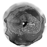
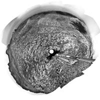
Thanks, Jan. I used the composite image to make a circular view - my orientation was a bit off with the earlier one from Paul. We will be weaving between dark sand patches for quite a while along this path.
Phil
-------------------- ... because the Solar System ain't gonna map itself.
Also to be found posting similar content on https://mastodon.social/@PhilStooke Maps for download (free PD: https://upload.wikimedia.org/wikipedia/comm...Cartography.pdf NOTE: everything created by me which I post on UMSF is considered to be in the public domain (NOT CC, public domain) |
|
 |
 
|
|
|
Jun 5 2020, 12:54 PM
Post
#122
|
||
|
Senior Member Group: Members Posts: 2822 Joined: 22-April 05 From: Ridderkerk, Netherlands Member No.: 353 |
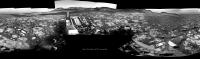
The Navcam L view on Sol 2783.
Jan van Driel
|
|
|
|
|
|
|
Jun 5 2020, 11:10 PM
Post
#123
|
||
|
Solar System Cartographer Group: Members Posts: 10153 Joined: 5-April 05 From: Canada Member No.: 227 |
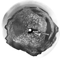
Very nice, Jan. Here is a circular projection of it showing the location relative to these dark sandy patches.
Phil
-------------------- ... because the Solar System ain't gonna map itself.
Also to be found posting similar content on https://mastodon.social/@PhilStooke Maps for download (free PD: https://upload.wikimedia.org/wikipedia/comm...Cartography.pdf NOTE: everything created by me which I post on UMSF is considered to be in the public domain (NOT CC, public domain) |
|
|
|
|
|
|
Jun 7 2020, 05:51 PM
Post
#124
|
||
|
Senior Member Group: Members Posts: 2822 Joined: 22-April 05 From: Ridderkerk, Netherlands Member No.: 353 |
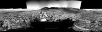
The MASTcam L view on Sol 2784.
Jan van Driel
|
|
|
|
|
|
|
Jun 8 2020, 05:54 PM
Post
#125
|
||
|
Senior Member Group: Members Posts: 2822 Joined: 22-April 05 From: Ridderkerk, Netherlands Member No.: 353 |
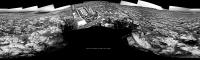
The Navcam L view on Sol 2786.
Jan van Driel
|
|
|
|
|
|
|
Jun 8 2020, 11:06 PM
Post
#126
|
||
|
Solar System Cartographer Group: Members Posts: 10153 Joined: 5-April 05 From: Canada Member No.: 227 |
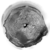
Thanks, Jan. This drive was about 60 m northeast through a gap in the dark sandy patches. Here's a circular projection to show the new location.
Phil
-------------------- ... because the Solar System ain't gonna map itself.
Also to be found posting similar content on https://mastodon.social/@PhilStooke Maps for download (free PD: https://upload.wikimedia.org/wikipedia/comm...Cartography.pdf NOTE: everything created by me which I post on UMSF is considered to be in the public domain (NOT CC, public domain) |
|
|
|
|
|
|
Jun 9 2020, 01:16 AM
Post
#127
|
||
 Senior Member Group: Members Posts: 2428 Joined: 30-January 13 From: Penang, Malaysia. Member No.: 6853 |
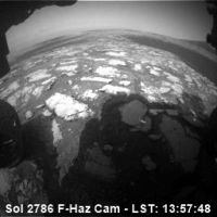
Here's a small (256x256) animated GIF of the Sol 2786 drive between the sand patches mentioned by Phil. The 14 frames were acquired with the front left hazcam. The sequence concludes with the a look back towards the setting sun and the path the rover had taken. The local timestamps are taken from JSON.
|
|
|
|
|
|
|
Jun 10 2020, 05:48 AM
Post
#128
|
||
|
Senior Member Group: Members Posts: 2428 Joined: 30-January 13 From: Penang, Malaysia. Member No.: 6853 |
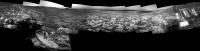
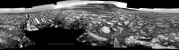
Sol 2788: Left navigation camera partial pan after another drive, roughly assembled in MS-ICE, but hopefully it can be used to provide a rough location until the rest of the images are downlinked
|
|
|
|
|
|
|
Jun 10 2020, 11:41 AM
Post
#129
|
||
|
Senior Member Group: Members Posts: 2822 Joined: 22-April 05 From: Ridderkerk, Netherlands Member No.: 353 |
The Navcam L view on Sol 2788.
Jan van Driel
|
|
|
|
|
|
|
Jun 10 2020, 05:40 PM
Post
#130
|
||
|
Solar System Cartographer Group: Members Posts: 10153 Joined: 5-April 05 From: Canada Member No.: 227 |
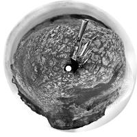
Thanks, Jan. Here is a circular version.
When compared with HiRISE images for my map, this shows a very good drive of about 80 m to the east, ending below a big elongated butte almost separated from the pediment. A rubble-covered patch thought to be a landslide deposit off the slope of the butte is just southeast of the rover. Phil -------------------- ... because the Solar System ain't gonna map itself.
Also to be found posting similar content on https://mastodon.social/@PhilStooke Maps for download (free PD: https://upload.wikimedia.org/wikipedia/comm...Cartography.pdf NOTE: everything created by me which I post on UMSF is considered to be in the public domain (NOT CC, public domain) |
|
|
|
|
|
|
Jun 12 2020, 07:06 PM
Post
#131
|
|
 Member Group: Members Posts: 809 Joined: 3-June 04 From: Brittany, France Member No.: 79 |
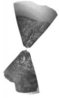
I made this animation using two RMI mosaics taken respectively on sol 2295 and 2726. It provides really different points of view on this cliff located 1,2 km South-East from the rover:
https://live.staticflickr.com/65535/4999930...14aebef4d_o.gif -------------------- |
|
|
|
|
Jun 12 2020, 10:40 PM
Post
#132
|
||
|
Solar System Cartographer Group: Members Posts: 10153 Joined: 5-April 05 From: Canada Member No.: 227 |
That's really nice!
Not much to go on yet for the sol 2790 drive, but the hazcams are enough for a pretty good estimate (usually they are not so helpful). Here's a projected version of a front-rear pair. Phil
-------------------- ... because the Solar System ain't gonna map itself.
Also to be found posting similar content on https://mastodon.social/@PhilStooke Maps for download (free PD: https://upload.wikimedia.org/wikipedia/comm...Cartography.pdf NOTE: everything created by me which I post on UMSF is considered to be in the public domain (NOT CC, public domain) |
|
|
|
|
|
|
Jun 13 2020, 02:07 PM
Post
#133
|
||
|
Senior Member Group: Members Posts: 2822 Joined: 22-April 05 From: Ridderkerk, Netherlands Member No.: 353 |
The Navcam L view on Sol 2790-2791.
Jan van Driel
|
|
|
|
|
|
|
Jun 13 2020, 08:25 PM
Post
#134
|
||
|
Solar System Cartographer Group: Members Posts: 10153 Joined: 5-April 05 From: Canada Member No.: 227 |
Much better than the Hazcam version! Thanks, Jan.
Phil
-------------------- ... because the Solar System ain't gonna map itself.
Also to be found posting similar content on https://mastodon.social/@PhilStooke Maps for download (free PD: https://upload.wikimedia.org/wikipedia/comm...Cartography.pdf NOTE: everything created by me which I post on UMSF is considered to be in the public domain (NOT CC, public domain) |
|
|
|
|
|
|
Jun 14 2020, 01:21 PM
Post
#135
|
|
|
Member Group: Members Posts: 809 Joined: 3-June 04 From: Brittany, France Member No.: 79 |
I made two photomontages to show RMI mosaics (sol 2295 and sol 2726) into a wider context provided by MastCam 100mm.
The featured steep cliff is about 10m high. To better grasp its scale, I added Matt Damon from the Martian movie and Curiosity rover itself. I also added the Statue of Liberty in another photomontage to grasp the scale of the background 100m high hill.    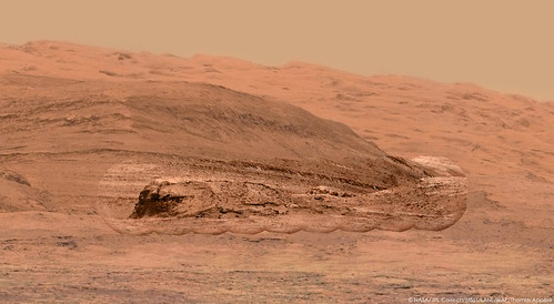  
-------------------- |
|
|
|
|

|
Lo-Fi Version | Time is now: 29th April 2024 - 09:16 PM |
|
RULES AND GUIDELINES Please read the Forum Rules and Guidelines before posting. IMAGE COPYRIGHT |
OPINIONS AND MODERATION Opinions expressed on UnmannedSpaceflight.com are those of the individual posters and do not necessarily reflect the opinions of UnmannedSpaceflight.com or The Planetary Society. The all-volunteer UnmannedSpaceflight.com moderation team is wholly independent of The Planetary Society. The Planetary Society has no influence over decisions made by the UnmannedSpaceflight.com moderators. |
SUPPORT THE FORUM Unmannedspaceflight.com is funded by the Planetary Society. Please consider supporting our work and many other projects by donating to the Society or becoming a member. |
|