Atop/Around the Greenheugh Pediment, Site 79-, sol 2695-3199, 3 Mar 2020-6 Aug 2021 |

  |
Atop/Around the Greenheugh Pediment, Site 79-, sol 2695-3199, 3 Mar 2020-6 Aug 2021 |
 Jul 17 2020, 12:55 PM Jul 17 2020, 12:55 PM
Post
#211
|
||
|
Senior Member  Group: Members Posts: 2823 Joined: 22-April 05 From: Ridderkerk, Netherlands Member No.: 353 |
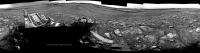
and the NAVcam L view on Sol 2824.
Jan van Driel
|
|
 |
 
|
|
|
Jul 17 2020, 08:07 PM
Post
#212
|
||
|
Solar System Cartographer Group: Members Posts: 10157 Joined: 5-April 05 From: Canada Member No.: 227 |
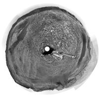
Thanks, Jan. This is the sol 2824 panorama in circular form. I used it to update the map.
Phil
-------------------- ... because the Solar System ain't gonna map itself.
Also to be found posting similar content on https://mastodon.social/@PhilStooke Maps for download (free PD: https://upload.wikimedia.org/wikipedia/comm...Cartography.pdf NOTE: everything created by me which I post on UMSF is considered to be in the public domain (NOT CC, public domain) |
|
|
|
|
|
|
Jul 22 2020, 12:12 PM
Post
#213
|
|
 Member Group: Members Posts: 809 Joined: 3-June 04 From: Brittany, France Member No.: 79 |
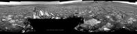
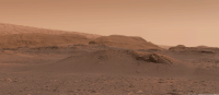
Mosaic of 3 MastCam Left pictures taken on sol 2826 (18 July) at 12:10 pm martian local time:
 And an older one taken on sol 2816 (8 July) with MastCam Right at 12:50 pm martian local time: 
-------------------- |
|
|
|
|
Jul 22 2020, 05:45 PM
Post
#214
|
||
|
Senior Member Group: Members Posts: 2823 Joined: 22-April 05 From: Ridderkerk, Netherlands Member No.: 353 |
The Navcam L view on Sol 2829.
Jan van Driel
|
|
|
|
|
|
|
Jul 22 2020, 06:27 PM
Post
#215
|
||
|
Solar System Cartographer Group: Members Posts: 10157 Joined: 5-April 05 From: Canada Member No.: 227 |
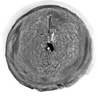
Jan's panorama in circular form - we moved north about 15 m.
Phil
-------------------- ... because the Solar System ain't gonna map itself.
Also to be found posting similar content on https://mastodon.social/@PhilStooke Maps for download (free PD: https://upload.wikimedia.org/wikipedia/comm...Cartography.pdf NOTE: everything created by me which I post on UMSF is considered to be in the public domain (NOT CC, public domain) |
|
|
|
|
|
|
Jul 23 2020, 02:46 AM
Post
#216
|
|
|
Founder Group: Chairman Posts: 14432 Joined: 8-February 04 Member No.: 1 |
QUOTE (Phil Stooke @ Jul 22 2020, 11:27 AM)  we moved north about 15 m. How's the map.  
|
|
|
|
|
Jul 23 2020, 06:35 AM
Post
#217
|
|
|
Solar System Cartographer Group: Members Posts: 10157 Joined: 5-April 05 From: Canada Member No.: 227 |
Fine for now - but don't push your luck! If you drive off the edge of the world don't say I didn't warn you.
Phil -------------------- ... because the Solar System ain't gonna map itself.
Also to be found posting similar content on https://mastodon.social/@PhilStooke Maps for download (free PD: https://upload.wikimedia.org/wikipedia/comm...Cartography.pdf NOTE: everything created by me which I post on UMSF is considered to be in the public domain (NOT CC, public domain) |
|
|
|
|
Jul 23 2020, 06:52 AM
Post
#218
|
|
|
Founder Group: Chairman Posts: 14432 Joined: 8-February 04 Member No.: 1 |
Were probably parked here for some time....then heading back SE. Lucky escape.
|
|
|
|
|
Jul 23 2020, 01:27 PM
Post
#219
|
||
 Senior Member Group: Members Posts: 2428 Joined: 30-January 13 From: Penang, Malaysia. Member No.: 6853 |
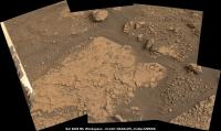
Candidate drill site 'Mozie Law'?
Sol 2829 L-MastCam, quick and dirty stitch of roughly reconstructed compressed bayer images. EDIT: Now called "Mary Anning"
|
|
|
|
|
|
|
Jul 23 2020, 08:06 PM
Post
#220
|
||
|
Member Group: Members Posts: 809 Joined: 3-June 04 From: Brittany, France Member No.: 79 |
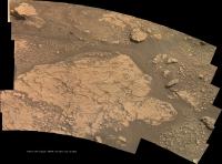
Panorama taken with MastCam Left on sol 2829 at 2:20 pm martian local time:
 And an animation between sols 2826 and 2829 showing the parallax due to a ~20m drive:
-------------------- |
|
|
|
|
|
|
Jul 27 2020, 07:24 PM
Post
#221
|
||
|
Senior Member Group: Members Posts: 2823 Joined: 22-April 05 From: Ridderkerk, Netherlands Member No.: 353 |
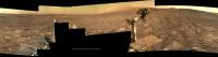
The MASTcam R view on Sol 2833.
Jan van Driel
|
|
|
|
|
|
|
Jul 31 2020, 11:34 AM
Post
#222
|
||
|
Senior Member Group: Members Posts: 2428 Joined: 30-January 13 From: Penang, Malaysia. Member No.: 6853 |
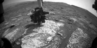
A little later than originally planned, but we now have another sample hole on Mars, "Mary Anning" was drilled during sol 2838
Front HazCam animated GIF (reduced in size for upload)
|
|
|
|
|
|
|
Jul 31 2020, 04:54 PM
Post
#223
|
||
|
Solar System Cartographer Group: Members Posts: 10157 Joined: 5-April 05 From: Canada Member No.: 227 |
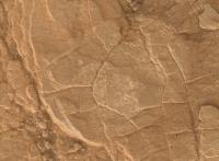
This is part of a MAHLI image from sol 2833. Most of the image is occupied by the DRT brushed area, a bit lighter than its surroundings and surounded by little dust grains. At the middle of it is a little notch pointing roughly in the 5 o'clock to 11 o'clock orientation - that's where the drill tip did a preload test, pushing against the rock to check it was stable enough to drill. It was not present when the DRT was first done earlier that sol.
Phil
-------------------- ... because the Solar System ain't gonna map itself.
Also to be found posting similar content on https://mastodon.social/@PhilStooke Maps for download (free PD: https://upload.wikimedia.org/wikipedia/comm...Cartography.pdf NOTE: everything created by me which I post on UMSF is considered to be in the public domain (NOT CC, public domain) |
|
|
|
|
|
|
Aug 2 2020, 02:26 PM
Post
#224
|
||
|
Senior Member Group: Members Posts: 2823 Joined: 22-April 05 From: Ridderkerk, Netherlands Member No.: 353 |
The MASTcam L view on Sol 2831.
Jan van Driel
|
|
|
|
|
|
|
Aug 3 2020, 05:26 PM
Post
#225
|
||
|
Solar System Cartographer Group: Members Posts: 10157 Joined: 5-April 05 From: Canada Member No.: 227 |
Nice view!
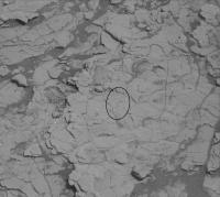
The ellipse in this image shows a cluster of small light-toned particles (plus a few scattered outside the ellipse) from a sample drop on sol 2839. Phil
-------------------- ... because the Solar System ain't gonna map itself.
Also to be found posting similar content on https://mastodon.social/@PhilStooke Maps for download (free PD: https://upload.wikimedia.org/wikipedia/comm...Cartography.pdf NOTE: everything created by me which I post on UMSF is considered to be in the public domain (NOT CC, public domain) |
|
|
|
|
|
|

|
Lo-Fi Version | Time is now: 3rd May 2024 - 10:58 PM |
|
RULES AND GUIDELINES Please read the Forum Rules and Guidelines before posting. IMAGE COPYRIGHT |
OPINIONS AND MODERATION Opinions expressed on UnmannedSpaceflight.com are those of the individual posters and do not necessarily reflect the opinions of UnmannedSpaceflight.com or The Planetary Society. The all-volunteer UnmannedSpaceflight.com moderation team is wholly independent of The Planetary Society. The Planetary Society has no influence over decisions made by the UnmannedSpaceflight.com moderators. |
SUPPORT THE FORUM Unmannedspaceflight.com is funded by the Planetary Society. Please consider supporting our work and many other projects by donating to the Society or becoming a member. |
|