Atop/Around the Greenheugh Pediment, Site 79-, sol 2695-3199, 3 Mar 2020-6 Aug 2021 |

  |
Atop/Around the Greenheugh Pediment, Site 79-, sol 2695-3199, 3 Mar 2020-6 Aug 2021 |
 May 5 2021, 03:56 AM May 5 2021, 03:56 AM
Post
#796
|
|
|
Solar System Cartographer  Group: Members Posts: 10153 Joined: 5-April 05 From: Canada Member No.: 227 |
Yet another halted drive - maybe third time will be lucky. At least it gives me a chance to catch up.
Phil -------------------- ... because the Solar System ain't gonna map itself.
Also to be found posting similar content on https://mastodon.social/@PhilStooke Maps for download (free PD: https://upload.wikimedia.org/wikipedia/comm...Cartography.pdf NOTE: everything created by me which I post on UMSF is considered to be in the public domain (NOT CC, public domain) |
 |
 
|
|
May 6 2021, 08:52 AM
Post
#797
|
||
 Senior Member Group: Members Posts: 2428 Joined: 30-January 13 From: Penang, Malaysia. Member No.: 6853 |
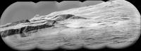
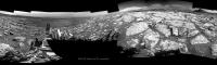
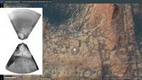
Sol 3109: A really crisp long-distance remote image mosaic of a target on "Mt. Sharp" that was first imaged about three years ago (mission update)
This mosaic was assembled in MS-ICE without any additional processing. Image Credit: NASA/JPL-Caltech/LANL
|
|
|
|
|
|
|
May 6 2021, 11:37 AM
Post
#798
|
||
|
Senior Member Group: Members Posts: 2820 Joined: 22-April 05 From: Ridderkerk, Netherlands Member No.: 353 |
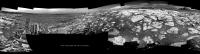
The NAVCam R view on Sol 3109.
Jan van Driel
|
|
|
|
|
|
|
May 6 2021, 11:28 PM
Post
#799
|
||
|
Solar System Cartographer Group: Members Posts: 10153 Joined: 5-April 05 From: Canada Member No.: 227 |
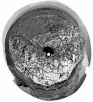
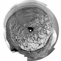
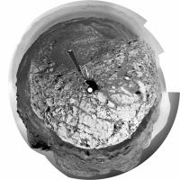
Thanks, Jan. Here is a circular version. We are slightly to the west of the sol 3083 position.
Phil
-------------------- ... because the Solar System ain't gonna map itself.
Also to be found posting similar content on https://mastodon.social/@PhilStooke Maps for download (free PD: https://upload.wikimedia.org/wikipedia/comm...Cartography.pdf NOTE: everything created by me which I post on UMSF is considered to be in the public domain (NOT CC, public domain) |
|
|
|
|
|
|
May 7 2021, 11:10 AM
Post
#800
|
||
|
Senior Member Group: Members Posts: 2820 Joined: 22-April 05 From: Ridderkerk, Netherlands Member No.: 353 |
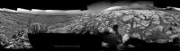
The NAVCam R view on Sol 3110.
Jan van Driel
|
|
|
|
|
|
|
May 7 2021, 08:23 PM
Post
#801
|
||
|
Solar System Cartographer Group: Members Posts: 10153 Joined: 5-April 05 From: Canada Member No.: 227 |
Thanks, Jan. Here is a circular view... only very slightly different from the previous view. We moved very slightly downhill (northwest) if I have it figured out properly. The mission update seemed to imply a move uphill, so it's possible that the drive was cut short by excessive tilt or a similar issue during the short drive.
Phil
-------------------- ... because the Solar System ain't gonna map itself.
Also to be found posting similar content on https://mastodon.social/@PhilStooke Maps for download (free PD: https://upload.wikimedia.org/wikipedia/comm...Cartography.pdf NOTE: everything created by me which I post on UMSF is considered to be in the public domain (NOT CC, public domain) |
|
|
|
|
|
|
May 10 2021, 11:18 AM
Post
#802
|
||
|
Senior Member Group: Members Posts: 2820 Joined: 22-April 05 From: Ridderkerk, Netherlands Member No.: 353 |
The NAVCam R view on Sol 3113.
Jan van Driel
|
|
|
|
|
|
|
May 10 2021, 01:24 PM
Post
#803
|
||
|
Senior Member Group: Members Posts: 1074 Joined: 21-September 07 From: Québec, Canada Member No.: 3908 |
Sol 3112 Lmastcam:
|
|
|
|
|
|
|
May 10 2021, 11:32 PM
Post
#804
|
||
|
Junior Member Group: Members Posts: 95 Joined: 11-January 07 From: Amsterdam Member No.: 1584 |
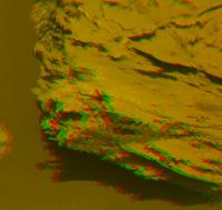
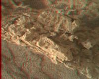
Mastcam anaglyph - sol 3110
This rough environment is extremely fragile 
-------------------- |
|
|
|
|
|
|
May 11 2021, 12:38 AM
Post
#805
|
||
|
Solar System Cartographer Group: Members Posts: 10153 Joined: 5-April 05 From: Canada Member No.: 227 |
Jan's sol 3113 panorama in circular format:
Another very small move. Phil -------------------- ... because the Solar System ain't gonna map itself.
Also to be found posting similar content on https://mastodon.social/@PhilStooke Maps for download (free PD: https://upload.wikimedia.org/wikipedia/comm...Cartography.pdf NOTE: everything created by me which I post on UMSF is considered to be in the public domain (NOT CC, public domain) |
|
|
|
|
|
|
May 12 2021, 07:11 PM
Post
#806
|
||
|
Senior Member Group: Members Posts: 2820 Joined: 22-April 05 From: Ridderkerk, Netherlands Member No.: 353 |
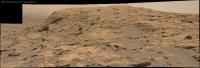
Sol 3113 MASTCam R.
Jan van Driel
|
|
|
|
|
|
|
May 12 2021, 07:23 PM
Post
#807
|
||
|
Senior Member Group: Members Posts: 2820 Joined: 22-April 05 From: Ridderkerk, Netherlands Member No.: 353 |
Sol 3112 MAHLI Stereo.
Jan van Driel
|
|
|
|
|
|
|
May 14 2021, 08:08 AM
Post
#808
|
||
 Member Group: Members Posts: 809 Joined: 3-June 04 From: Brittany, France Member No.: 79 |
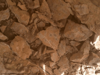
A montage of two MAHLI pictures taken on sol 3110 (6 May 2021) of sharp edge rocks broken by Curiosity's wheels, and a animation giving a perception of depth using https://wigglemaker.ugocapeto.com/.

-------------------- |
|
|
|
|
|
|
May 14 2021, 12:54 PM
Post
#809
|
||
|
Senior Member Group: Members Posts: 2428 Joined: 30-January 13 From: Penang, Malaysia. Member No.: 6853 |
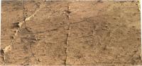
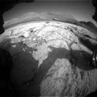
Drive to the South? Sol 3117: Front Hazard Avoidance Camera
|
|
|
|
|
|
|
May 14 2021, 06:21 PM
Post
#810
|
||
|
Solar System Cartographer Group: Members Posts: 10153 Joined: 5-April 05 From: Canada Member No.: 227 |
I get this location from the hazcams.
Phil
-------------------- ... because the Solar System ain't gonna map itself.
Also to be found posting similar content on https://mastodon.social/@PhilStooke Maps for download (free PD: https://upload.wikimedia.org/wikipedia/comm...Cartography.pdf NOTE: everything created by me which I post on UMSF is considered to be in the public domain (NOT CC, public domain) |
|
|
|
|
|
|

|
Lo-Fi Version | Time is now: 27th April 2024 - 05:26 PM |
|
RULES AND GUIDELINES Please read the Forum Rules and Guidelines before posting. IMAGE COPYRIGHT |
OPINIONS AND MODERATION Opinions expressed on UnmannedSpaceflight.com are those of the individual posters and do not necessarily reflect the opinions of UnmannedSpaceflight.com or The Planetary Society. The all-volunteer UnmannedSpaceflight.com moderation team is wholly independent of The Planetary Society. The Planetary Society has no influence over decisions made by the UnmannedSpaceflight.com moderators. |
SUPPORT THE FORUM Unmannedspaceflight.com is funded by the Planetary Society. Please consider supporting our work and many other projects by donating to the Society or becoming a member. |
|