Full Version: Post Conjunction: Santa Maria to Cape York
Pages: 1, 2, 3, 4, 5, 6, 7, 8, 9, 10, 11, 12, 13, 14, 15, 16, 17, 18, 19, 20, 21, 22, 23, 24, 25, 26, 27, 28, 29, 30, 31, 32
.
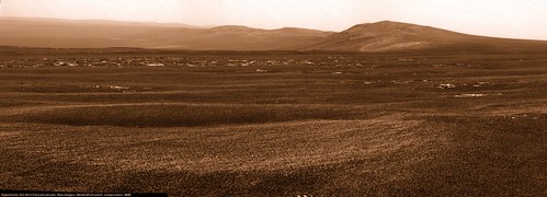
Indeed. Here's my version of the sol 2674 Pancam mosaic, with color added.
Here's my guess for our 2674 location based purely on the imagery:
Click to view attachment
It looks like a good drive, almost directly south.
And I'm pretty sure we can now see the rim of Spirit Point crater!
Click to view attachment
Another drive or two like this and we'll finally be able to see down the throat of Botany Bay...
Click to view attachment
It looks like a good drive, almost directly south.
And I'm pretty sure we can now see the rim of Spirit Point crater!
Click to view attachment
Another drive or two like this and we'll finally be able to see down the throat of Botany Bay...
I couldn't help but include a certain rover of sweet disposition: Oppy at Spirit Point Crater and Endeavor beyond! (My apologies if the scale is off.)
Click to view attachment
Click to view attachment
Can we say "Land Ahoy!" now?! 
Click to view attachment
I know that I'm singng "Bound for Botany Bay..."
Click to view attachment
I know that I'm singng "Bound for Botany Bay..."
Nice, Astro0... I used your mosaic for an artistic wallpaper, with false colors, artificial sky and enhanced details/contrast on far plane:
Click to view attachment Click to view attachment
Second version is 2x vertical stretch (which I prepfer...!)
Click to view attachment Click to view attachment
Second version is 2x vertical stretch (which I prepfer...!)
What a big difference this 120 meter drive makes. Whole crater seems to open up.
2 Philovisioned panoramas, taken on sol2671 and sol2674 switching in this animated GIF.
Click to view attachment
2 Philovisioned panoramas, taken on sol2671 and sol2674 switching in this animated GIF.
Click to view attachment
QUOTE (fredk @ Aug 3 2011, 05:18 AM) 
And I'm pretty sure we can now see the rim of Spirit Point crater!
Isn't that a bit far over to the left, Fred? Looking at HiRISE images of CY, the crater is almost on the very southern end. I'm wondering if the crater is this feature...
Click to view attachment
...but more than prepared to be proved wrong!

I think Fred is right, that looks in about the right place. Stu yours is too far right, way past the end of CY.
Ok, thanks James, appreciate that. I'm still not sure what we're IDing as the end of CY.
What are you unsure about? I think we can see all of CY now with the feature Fred ID'd as being Spirit Point at the end. To the right of that are mounds/ripples on the edge of Botany Bay.
Gentlemen! Have a look at this anaglyph, in 50 % size. I would estimate that the crater of Spirit Point is many meters lower than us and as yet hidden by the downwards curving south tip of CY. Also note how the central upper surface of CY truly seems to be an almost seamlessly level continuation of the Meridiani plain (only that there is a seam). The destination crater would be located clearly lower than the upper surface and plain.
If that's Cape York, from this angle Cape York looks nothing like I thought it would. Not expressing disappointment there, more like fascination.
I agree marswiggle, I was just looking at Peter's contour map again and I think that while we are now seeing the SP end of CY we can't quite see the crater itself as it on the inside slope (i.e. it's on the other side of the mound Fred pointed at)
From the Cape York DEM thread, here's a west(Left)-to-east(Right) transect of Spirit Point crater. Not much vertical topography associated with the rim, and it appears that we may see the far rim before the near.
Click to view attachment
Click to view attachment
QUOTE (Toma B @ Aug 3 2011, 11:57 AM)
What a big difference this 120 meter drive makes. Whole crater seems to open up.
2 Philovisioned panoramas, taken on sol2671 and sol2674 switching in this animated GIF.
2 Philovisioned panoramas, taken on sol2671 and sol2674 switching in this animated GIF.
Toma B...that is just breathtaking, I quitted asking if we are there yet. we are HERE, and HERE...is awesome.
QUOTE (Toma B @ Aug 3 2011, 11:57 AM)
What a big difference this 120 meter drive makes. ... 2 Philovisioned panoramas, taken on sol2671 and sol2674 switching in this animated GIF.
Wow... that must be one of the most striking things I've seen on UMSF since I joined, back in medieval times. That's just... stunning. Good work, Toma!

QUOTE (algorimancer @ Aug 3 2011, 03:39 PM)
... it appears that we may see the far rim before the near.
Actually it could be that we'll first see the "big" rock visible there on the HiRise... sort of Beacon on the far rim

Thank you Rui and Stuart. Just trying to make myself worthy of THIS WONDERFUL PLACE that we call UMSF.
Oh my God. I haven't been following Oppy for ages...she's made it! Too awesome!
Yep, that was too early to call Spirit Point crater. I don't think we can see Spirit Point yet. Here's what I'm now (almost certain!) the mound visible in pancam is:
Click to view attachment
There are several converging lines of evidence for this identification: Absolute heading is correct. Width of feature is correct. Connection to foreground features in pancam correct. Position consistent with start of steep dropoff into Botany Bay, as others have pointed out.
What's the saying? "Measure twice, cut once."
Not sure if this helps, but I made a little movie of the view from and rising above Opportunity at the moment, looking towards Spirit Point.
Made using my HiRISE DEM, so it comes with the usual caveats, plus the added bonus of I'm not sure if even I've put the view in the right place!
It's too big for here (~5 Mb), so here's the link to the animated gif: http://twitpic.com/60e5f7
And a single frame to entice you on over...or not
Click to view attachment
Pete
Edit: fredk - I think you're spot on. The movie suggests that there is something in the way of Spirit Point at the moment. Not for long though I'm sure.
QUOTE (Toma B @ Aug 3 2011, 10:57 AM)
2 Philovisioned panoramas, taken on sol2671 and sol2674 switching in this animated GIF.
Wow, I have to add to what others have already said. That's incredibly cool for a bunch of reasons:Dramatic horizon drop.
You can tell we've moved almost directly towards Trib - in fact, you can see it getting bigger, and especially Solander point!
The far rim and Iazu get hazier. (Bad in a sense, but it gives a better sense of distance.)
Definitely one of the most striking images of the mission!
QUOTE (pgrindrod @ Aug 3 2011, 09:56 AM)
...made a little movie...
Any chance you could post a version slowed-down by a factor of 10 or 20? This is great, but rotates too fast for me to see clearly what the horizon should look like.
Does anyone know what kind of rock type is Oppy going to IDD first, when she reaches Spirit Point? Is she going to IDD first a rock target at Botany Bay? What are these rocks (at Botany Bay) made of exactly (sulfate rocks, as seen in Meridiani Plains)? 

Oh My God, Oh My God, Oh My God!!
Since I read "Red Mars" in 1995, I have been dreaming of such vistas!
Spirit got the first one from the top of Husband hill, but this... this!!
It's like Oppy has landed yet again, for the umpteenth time!
Since I read "Red Mars" in 1995, I have been dreaming of such vistas!
Spirit got the first one from the top of Husband hill, but this... this!!
It's like Oppy has landed yet again, for the umpteenth time!
QUOTE (walfy @ Aug 3 2011, 07:01 AM)
I couldn't help but include a certain rover of sweet disposition: Oppy at Spirit Point Crater and Endeavor beyond! (My apologies if the scale is off.)
Thank you for this. It is beautiful.
QUOTE (Deimos @ Aug 2 2011, 05:17 PM)
For dust perfectly mixed through the whole atmosphere, the opacity across the crater would be about twice the measured (zenith) value on any given sol. I wonder if visibility might get worse before it gets better, even as the dust settles. We'll be testing that, of course.
Thank you. I'm fairly sure I follow you on that point. A neat little meteorology experiment the crater Endeavour offers!
-- Pertinax
So now I've had an evening in front of my computer rather than speculating from work, I have come to the same conclusion as Fred. Spirit Point is STILL below the horizon.
Here are my ID's of the horizon features on a reprojected HiRISE image. It also shows what is just over the ridge in the same direction. (Each column of pixels is a line of sight from Oppy's current position.)
Click to view attachment
Here are my ID's of the horizon features on a reprojected HiRISE image. It also shows what is just over the ridge in the same direction. (Each column of pixels is a line of sight from Oppy's current position.)
Click to view attachment
Wow. Thanks for that James.
James, on your post, the big rock on the other side of Spirit (crater) point looks like Spirit (or Oppy) herself as seen from orbit.
Sol 2670-2671 360x90 degree Navcam panorama. This might be my favorite Navcam panorama of the mission so far, for what it represents as well as for the mind-blowing view to the northeast. This version is centered on east. Just to the south of east is the line between Sol 2670 and 2671 images; it was difficult to reconcile the different lighting without destroying one or more images, so I chose not to destroy the images. And those undulations in the ground to the northeast are not distortions in the projection but are real, at least as far as I can tell. I've posted a hi-quality JPG so have at it.
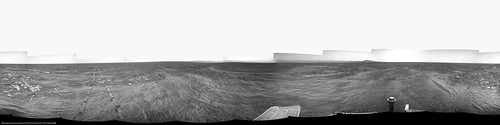
And the QuickTime VR version (download the file first, it's 6.1MB)
And the QuickTime VR version (download the file first, it's 6.1MB)
I think, "gee, it would be cool to see those 2670-71 navcams stitched together", check out UMSF, and what do I see! Thanks - that's a pivotal mosaic for sure.
It's very cool that we're already seeing the bottom centre of Endeavour. As you pointed out, the south end is a lot deeper, and we're quite a ways from seeing the bottom there yet...
QUOTE (marswiggle @ Jul 29 2011, 03:01 AM)
The dark flat feature in the new navcam image really seems oddly flat and featureless for CY, which makes me think it could alternatively be our first glimpse of the dark material that is filling the north-center bottom of Endeavour, lying higher than the margins and the south part
At the time I thought that was the flat, lower part of CY, but now I think it's clear you were right, marswiggle. In the 2670-71 navcams you can see how that flat feature trails off into the haze to the left, so it can't be as close as CY. And also the flat feature hasn't moved in relation to the far rim. So all we've seen of CY yet is the highest north end.It's very cool that we're already seeing the bottom centre of Endeavour. As you pointed out, the south end is a lot deeper, and we're quite a ways from seeing the bottom there yet...
That circular version works well, Phil.  Thanks, Fred.
Here's my favorite part of the view, done as a perspective projection. I've saved it as a lossless PNG in case anyone wants to improve/mess with it.
Thanks, Fred.Here's my favorite part of the view, done as a perspective projection. I've saved it as a lossless PNG in case anyone wants to improve/mess with it.
QUOTE (mhoward @ Aug 4 2011, 04:21 AM)
Here's my favorite part of the view, done as a perspective projection. I've saved it as a lossless PNG in case anyone wants to improve/mess with it.
This is my version (lot of work ti improve distant mountains...)
QUOTE (Phil Stooke @ Aug 3 2011, 11:33 PM)
Fantastic! And as is my want, I've made a circular version of it:
Phil
Phil
Gee Phil, I appreciate the purity of that circular image, but I'm also wondering how it might look if you pasted in an aerial view of the rover onto that. It'd be artificial and all, but the orientating effect ought to be strong.
In this collaborative world of UMSF, that sounds like a job for Stu!
Phil
Phil
QUOTE (climber @ Aug 3 2011, 01:58 PM)
James, on your post, the big rock on the other side of Spirit (crater) point looks like Spirit (or Oppy) herself as seen from orbit.
Haha, I brought this up at a team meeting on Tuesday and nobody seemed to agree.
QUOTE (dilo @ Aug 4 2011, 12:23 AM)
This is my version (lot of work ti improve distant mountains...)
Very nice! Feel free to change the credit line to NASA/JPL/M.Howard/M.Di Lorenzo
(Also I messed up and left a bit of unretouched sky on the far right, which bugs me, but oh well.)
I also did a version of the earlier sol 2668-2669 Navcam panorama if anyone wants it.
Flipping between those two circular projections is pretty cool. It should be even better if/when we get a full Navcam panorama from the current site.
Please pardon the momentary departure from areology to aesthetics, and from empirics to emotion. Put another way, Stu and Ustrax may understand this better than others .
There have been many proclamations of late on how this is like a brand new mission for Oppy, and rightly so. More so that I ever imagined possible. As I share with all here the joy of reaching a destination that seemed both optimistically reachable but yet impossibly far away, and am awed by the spectacle before our eyes, I am increasingly struck by the how familiar this all feels.
It's the landscape.
Absolutely I am excited about scooping MSL with a ground truth discovery of phyllosilicates along with the engineering wonder that is Opportunity's every new day. But these in some ways pale to the raw sense of deja vu that Endeavour is evoking. It is as if Spirit's heart is resting in this place. Every time we gaze through PANCAM out over Solander toward Cape Trib I gutturally feel the same stirring of excitement that the Columbia Hills evoked so many sols ago. These first true hills we've encountered in Meridiani are looming large, beckoning Oppy to follow, prorsum et sursum, onward in her sister's spirit, and to strive upward in her stead to explore the heights and from there plumb the depths of Endeavour and the terrain beyond.
Thank you to all who have brought us this far on these fantastic voyages of exploration!
-- Pertinax
.There have been many proclamations of late on how this is like a brand new mission for Oppy, and rightly so. More so that I ever imagined possible. As I share with all here the joy of reaching a destination that seemed both optimistically reachable but yet impossibly far away, and am awed by the spectacle before our eyes, I am increasingly struck by the how familiar this all feels.
It's the landscape.
Absolutely I am excited about scooping MSL with a ground truth discovery of phyllosilicates along with the engineering wonder that is Opportunity's every new day. But these in some ways pale to the raw sense of deja vu that Endeavour is evoking. It is as if Spirit's heart is resting in this place. Every time we gaze through PANCAM out over Solander toward Cape Trib I gutturally feel the same stirring of excitement that the Columbia Hills evoked so many sols ago. These first true hills we've encountered in Meridiani are looming large, beckoning Oppy to follow, prorsum et sursum, onward in her sister's spirit, and to strive upward in her stead to explore the heights and from there plumb the depths of Endeavour and the terrain beyond.
Thank you to all who have brought us this far on these fantastic voyages of exploration!
-- Pertinax
The drive on 2676 may be our last long drive for some time (from here):
QUOTE
In the queue for sol 2676 is another 120 meters. This will put us within spitting distance -- or one long-distance drive -- away from Spirit Point. We likely will not be doing that, but rather carefully navigating inward. We're taking our foot off the pedal a bit. It's time to get back into the science collection mindset.
Well said.
I've always wondered about the well known large martian features; their scale is simply to great to really absorb on the ground. Valles Marineris is so wide it probably looks nothing like Earth's canyons except at the narrow ends; same for Olympus Mons and other volcanoes, their slopes are so gradual you don't see the whole mountain at all. Spirit could see the walls of Gusev, weather permitting, but they were featureless at that distance.
Endeavour's scale is really perfect.
Sol 2674 Post Drive PanCam contrast tweaked to bring out "the edge"
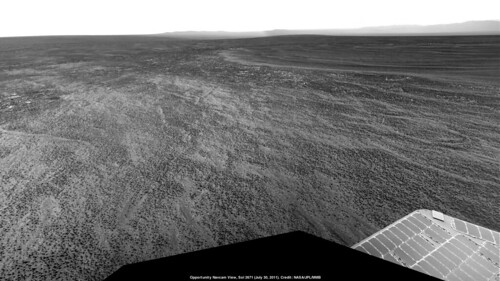
Could someone identify this object on the horizon (Sol 2668)? It must be south of us and west of Cape Trib.
Are we there yet?
Are we there yet?
QUOTE (MoreInput @ Aug 4 2011, 09:57 PM)
Are we there yet?
Not quite there but we are getting closer each drive.

According to Pancam Data Tracking site, Opportunity drove some 117 meters today and if I have not been assured that we are going to the Spirit Point I would definitely thought we are going to Cape Tribulation.
I can't wait to see new images.
Can't wait too! One question there I've lost track of, regarding time of pictures posted on the Exploratorium, is that P.D.T?
Edited: You may have seen one target is called "Montevideo". I play it like Rui to tell that one of reason the Capital of Uruguay was named this way was from Portuguese "Monte vide eu", which means "I see a Mountain".
Personaly I can see plenty.
Edited: You may have seen one target is called "Montevideo". I play it like Rui to tell that one of reason the Capital of Uruguay was named this way was from Portuguese "Monte vide eu", which means "I see a Mountain".
Personaly I can see plenty.
This is a "lo-fi" version of our main content. To view the full version with more information, formatting and images, please click here.